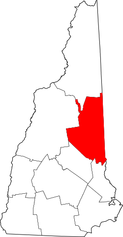
- Carroll County (New Hampshire)
-
Verwaltung US-Bundesstaat: New Hampshire Verwaltungssitz: Ossipee Gründung: 1840 Demographie Einwohner: 43.666 (2000) Bevölkerungsdichte: 18,1 Einwohner/km² Geographie Fläche gesamt: 2.570 km² Wasserfläche: 151 km² Karte Carroll County[1] ist ein County im Bundesstaat New Hampshire der Vereinigten Staaten von Amerika. 2000 lebten hier 43.666 Menschen. Der Verwaltungssitz (County Seat) ist Ossipee.
Inhaltsverzeichnis
Geographie
Die County hat eine Fläche von 2570 Quadratkilometern. Davon sind 151 Quadratkilometer (5,89 Prozent) Wasserflächen.
Nachbarcountys
- Coos County (New Hampshire) , Norden
- Oxford County (Maine), Nordosten
- York County (Maine), Südosten
- Strafford County (New Hampshire), Süden
- Belknap County (New Hampshire), Südwesten
- Grafton County (New Hampshire), Westen
Geschichte
Carroll County wurde 1840 aus den nördlichen Teilen des Strafford County gebildet und nach Charles Carroll, einem Unterzeichner der Amerikanischen Unabhängigkeitserklärung aus Maryland, benannt.
Bevölkerungsentwicklung
1980 1990 2000 2005 27.730 35.410 43.666 47.439 Städte
Carroll County teilt sich in 17 towns (Städte) und ein gemeindefreies Gebiet. Eine city (ebenfalls mit Stadt übersetzt) besteht nicht.
Gemeinden
- Albany, 654
- Bartlett, 2705
- Brookfield, 604
- Chatham, 260
- Eaton, 375
- Effingham, 1273
- Freedom, 1303
- Hart's Location, 37
- Jackson, 835
- Madison, 1984
- Moultonborough, 4484
- Ossipee, 4421
- Sandwich, 1286
- Tamworth, 2610
- Tuftonboro, 2148
- Wakefield, 4252
- Wolfeboro, 6083
Gemeindefreie Gebiete
- Hale's Location, 58
Einzelnachweise
- ↑ GNIS-ID: 873175. Abgerufen am 22. Februar 2011 (englisch).
Liste der Countys in New Hampshire
Belknap | Carroll | Cheshire | Coos | Grafton | Hillsborough | Merrimack | Rockingham | Strafford | Sullivan
Wikimedia Foundation.
Schlagen Sie auch in anderen Wörterbüchern nach:
Carroll County, New Hampshire — Infobox U.S. County county = Carroll County state = New Hampshire map size = 100 founded = 1840 seat = Ossipee | area total sq mi =992 area land sq mi =934 area water sq mi =58 area percentage = 5.89% census yr = 2000 pop = 43666 density km2 =18… … Wikipedia
National Register of Historic Places listings in Carroll County, New Hampshire — Location of Carroll County in New Hampshire This is a list of the National Register of Historic Places listings in Carroll County, New Hampshire. This is intended to be a complete list of the properties and districts on the National Register of… … Wikipedia
Historical U.S. Census Totals for Carroll County, New Hampshire — This article shows U.S. Census totals for Carroll County, New Hampshire, broken down by municipality, from 1900 to 2000.Most areas of New England are entirely divided into incorporated municipalities, with no unincorporated territory. In the… … Wikipedia
Mount Kearsarge (Carroll County, New Hampshire) — This article is about the mountain near North Conway, New Hampshire. For the mountain of the same name in Wilmot and Warner, New Hampshire, see Mount Kearsarge (Merrimack County, New Hampshire). For other uses, see Kearsarge (disambiguation).… … Wikipedia
List of Registered Historic Places in Carroll County, New Hampshire — List of Registered Historic Places in Carroll County, New Hampshire. ee also* List of Registered Historic Places in New HampshireReferences … Wikipedia
Coos County (New Hampshire) — Verwaltung US Bundesstaat: New Hampshire Verwaltungssitz: Lancaster Adresse des Verwaltungssitzes: Gründung … Deutsch Wikipedia
Grafton County (New Hampshire) — Verwaltung US Bundesstaat: New Hampshire Verwaltungssitz: Haverhill Adresse des Verwaltungssitzes: Gründung … Deutsch Wikipedia
Strafford County (New Hampshire) — Verwaltung US Bundesstaat: New Hampshire Verwaltungssitz: Dover Adresse des Verwaltungssitzes: Gründung … Deutsch Wikipedia
Belknap County (New Hampshire) — Verwaltung US Bundesstaat: New Hampshire Verwaltungssitz: Laconia Adresse des Verwaltungssitzes: Gründung … Deutsch Wikipedia
Cheshire County (New Hampshire) — Verwaltung US Bundesstaat: New Hampshire Verwaltungssitz: Keene Adresse des Verwaltungssitzes: Gründung: 1789 … Deutsch Wikipedia