- Kaktovik
-
Kaktovik 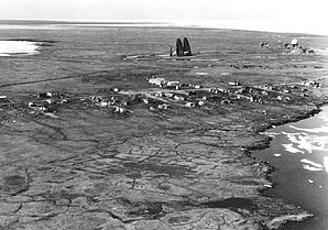
Luftbild von KaktovikLage in Alaska 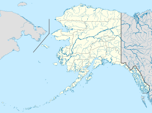

Kaktovik Basisdaten Staat: Vereinigte Staaten Bundesstaat: Alaska Borough: Koordinaten: 70° 8′ N, 143° 37′ W70.132777777778-143.61611111111Koordinaten: 70° 8′ N, 143° 37′ W Zeitzone: Alaska Standard Time (UTC−9) Einwohner: 293 (Stand: 2000) Bevölkerungsdichte: 146,5 Einwohner je km² Fläche: 2,6 km² (ca. 1 mi²)
davon 2,0 km² (ca. 1 mi²) LandVorwahl: +1 907 FIPS: 02-36990 GNIS-ID: 2419404 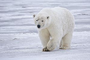
Eisbär nahe KaktovikKaktovik ist eine Stadt im North Slope Borough im Bundesstaat Alaska in den Vereinigten Staaten.
Inhaltsverzeichnis
Geografie
Kaktovik liegt am nördlichen Ufer von Barter Island zwischen den Okpilak- und Jago Rivern an der Küste der Beaufortsee. Das Gebiet liegt im 78.053 km² umfassenden Naturschutzgebiet Arctic National Wildlife Refuge. Es herrscht ein arktisches Klima mit wenig Niederschlag.
Geschichte
Kaktovik wurde von dem Eskimo-Stamm der Inupiat besiedelt. Bis gegen Ende des 19. Jahrhunderts war die Gegend ein Haupthandelsplatz für die Inupiat. Von besonderer Bedeutung war die Fischerei. In den 1950er-Jahren zogen Siedler aus dem nördlichen Alaska in die Gegend, um am Bau einer Start- und Landebahn sowie einer Radarstation der Distant Early Warning Line mitzuwirken. 1971 wurde Kaktovik als City inkorporiert.
Wirtschaft und Infrastruktur
Die Infrastruktur stellt der North Slope Borough zur Verfügung. Es gibt in Kaktovik eine Schule und ein Krankenhaus, die Kaktovik Clinic. Die Einwohner ernähren sich hauptsächlich von Karibu-Fleisch. Arbeitsmöglichkeiten bieten die Schule, das Krankenhaus sowie die Verwaltung der Stadt und des Boroughs. In der Nähe von Kaktovik befindet sich ein bekannter Flughafen, der Barter Island LRRS Airport, der die einzige ganzjährige Erreichbarkeit des auf dem Landweg isolierten Gebietes sicherstellt.
Demografie
Zum Zeitpunkt der Volkszählung im Jahre 2000 (U.S. Census 2000) hatte Kaktovik 293 Einwohner auf einer Landfläche von 2,0 km². Das Medianalter betrug 32,1 Jahre (nationaler Durchschnitt der USA: 35,3 Jahre). Das Pro-Kopf-Einkommen (engl. per capita income) lag bei US-Dollar 22.031 (nationaler Durchschnitt der USA: US-Dollar 21.587). 6,6% der Einwohner lagen mit ihrem Einkommen unter der Armutsgrenze (nationaler Durchschnitt der USA: 12,4%).[1] Etwa 84% der Einwohner von Point Hope sind indigener Abstammung, die in dem bundesweit anerkannten Indianerreservat The Kaktovik Village (auch bekannt als The Barter Island Village) leben. Bedingt auch durch die Abgeschiedenheit des Gebietes bewahren die Inupiat-Eskimos ihre alten Traditionen. So ist der Besitz und der Handel mit Alkohol im Reservat verboten.
Einzelnachweise
Weblinks
- The City of Kaktovik offizielle Webseite (englisch)
- Datenbank der Gemeinden Alaskas: Kaktovik (englisch)
- Statistiken über Kaktovik bei city-data.com (englisch)
Städte und Census-designated places im North Slope BoroughAlpine | Anaktuvuk Pass | Atqasuk | Barrow | Kaktovik | Nuiqsut | Point Hope | Point Lay | Prudhoe Bay | Wainwright
Wikimedia Foundation.
Schlagen Sie auch in anderen Wörterbüchern nach:
Kaktovik — Kaktovik, Alaska Escudo … Wikipedia Español
Kaktovik — Kaktovik, AK U.S. city in Alaska Population (2000): 293 Housing Units (2000): 95 Land area (2000): 0.789755 sq. miles (2.045455 sq. km) Water area (2000): 0.205902 sq. miles (0.533283 sq. km) Total area (2000): 0.995657 sq. miles (2.578738 sq.… … StarDict's U.S. Gazetteer Places
Kaktovik, AK — U.S. city in Alaska Population (2000): 293 Housing Units (2000): 95 Land area (2000): 0.789755 sq. miles (2.045455 sq. km) Water area (2000): 0.205902 sq. miles (0.533283 sq. km) Total area (2000): 0.995657 sq. miles (2.578738 sq. km) FIPS code:… … StarDict's U.S. Gazetteer Places
Kaktovik, Alaska — Infobox Settlement official name = Kaktovik, Alaska settlement type = City nickname = motto = imagesize = image caption = image mapsize = 250px map caption = Location of Kaktovik, Alaska mapsize1 = map caption1 = subdivision type = Country… … Wikipedia
Kaktovik (Alaska) — 70° 07′ 58″ N 143° 36′ 58″ W / 70.132778, 143.616111 … Wikipédia en Français
99747 — Kaktovik, Ak (Miscellaneous » ZIP Codes) … Abbreviations dictionary
Arctic Refuge drilling controversy — Arctic National Wildlife Refuge Map The question of whether to drill for oil in the Arctic National Wildlife Refuge (ANWR) has been an ongoing political controversy in the United States since 1977.[1] The issue has been used by both Democrats and … Wikipedia
Бартер (остров) — У этого термина существуют и другие значения, см. Бартер (значения). Бартер Barter Island Qaaktuġvik Координаты: Координаты … Википедия
Arctic National Wildlife Refuge — Infobox protected area | name = Arctic National Wildlife Refuge iucn category = IV caption = Map of the United States locator x = 40 locator y = 140 location = North Slope Borough and Yukon Koyukuk Census Area, Alaska, USA nearest city = Barrow,… … Wikipedia
North Slope Borough, Alaska — Seal … Wikipedia
Kaktovik


18+
© Academic, 2000-2026
- Kontaktieren Sie uns: Unterstützung, Werbung
Wörterbücher Export, schritte mit PHP, Joomla, Drupal, WordPress, MODx.