Kimberley (British Columbia)

Kimberley (British Columbia)
Kimberley
Motto: "Recordamur Omnium"
(lat.) "Wir sind für alles aufmerksam"
Lage in British Columbia
Kimberley (British Columbia)
Kimberley
Kimberley
Staat: Kanada
Provinz: British Columbia
Regionaldistrikt: East Kootenay
Koordinaten: 49° 40′ N, 115° 59′ W49.669722222222-115.97751120Koordinaten: 49° 40′ N, 115° 59′ W
Höhe: 1.120 m
Fläche: 58,31 km²
Einwohner: 7289 (Stand: 2007)
Bevölkerungsdichte: 125 Einw./km²
Zeitzone: Mountain Time (UTC−7)
Postleitzahl: V1A
Vorwahl: +1 250
Gründung: 1944
Bürgermeister: James E. Ogilvie
Webpräsenz: www.city.kimberley.bc.ca

Kimberley ist eine kleine Stadt im Südosten der kanadischen Provinz British Columbia. Sie wurde 1896 nach der Kimberley Mine in Kimberley (Südafrika) benannt und 1944 wurde Ihr das Stadtrecht verliehen.

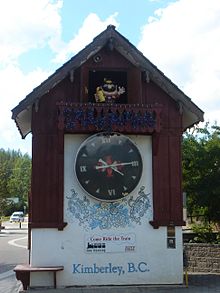
Bayerische Kuckucksuhr von Kimberley.

Durch Kimberley führt der British Columbia Highway 95A.

Zwischen 1917 und 2001 war die Sullivan Mine in Kimberley die weltgrößte Blei- und Zinkmine.

Heute ist der Tourismus rund um das Kimberley Alpine Resort, ein Wintersportgebiet, und die Kimberley Underground Mining Railway, eine Untergrund-Mineneisenbahn mit einer 230 m langen Bergbauausstellung, Haupteinnahmequelle der Stadt.

In der Stadt gibt es die größte frei stehende Kuckucksuhr Kanadas.

Töchter und Söhne der Stadt

Weblinks


Wikimedia Foundation.

Игры ⚽ Нужен реферат?

Schlagen Sie auch in anderen Wörterbüchern nach:

  • Kimberley, British Columbia — Kimberley Motto: Recordamur Omnium   (Latin) We Are Mindful Of All …   Wikipedia

  • British Columbia — Colombie Britannique (French) …   Wikipedia

  • British Columbia Highway 95 — Infobox road province=BC type=Hwy route=95 maint= length km= length round= length ref= established= direction a= starting terminus= junction= direction b= ending terminus= previous type=Hwy previous route=93 next type=Hwy next route=97Highway 95… …   Wikipedia

  • British Columbia municipal elections, 2005 — The Canadian province of British Columbia held its triannual municipal elections on November 19, 2005. Voters in each of BC s 157 municipalities elected mayors and councillors, and rural voters elected directors for their regional district… …   Wikipedia

  • Cranbrook, British Columbia — Cranbrook   City   City of Cranbrook, British Columbia Downtown Cranbrook …   Wikipedia

  • Invermere, British Columbia — Infobox Settlement official name = Pagename other name = native name = nickname = settlement type = Municipality motto = imagesize = image caption = Invermere, British Columbia, with Mount Nelson in the distance flag size = image seal size =… …   Wikipedia

  • Victoria, British Columbia — For other uses, see Victoria (geographical disambiguation). This article is about the city of Victoria. For electoral districts with the name Victoria, or in the area of Greater Victoria, see Victoria (electoral districts). City of Victoria… …   Wikipedia

  • Chilliwack, British Columbia — Chilliwack City of Chilliwack Flag …   Wikipedia

  • Surrey, British Columbia — Surrey   City   City of Surrey …   Wikipedia

  • Abbotsford, British Columbia — City of Abbotsford Partial Abbotsford skyline from Mill Lake …   Wikipedia

Share the article and excerpts

Direct link
Do a right-click on the link above
and select “Copy Link”