- Ľutina
-
Ľutina
Wappen Karte  Basisdaten
Kraj: Prešovský kraj Okres: Sabinov Region: Šariš Fläche: 6,906 km² Einwohner: 451 (31. Dez. 2010) Bevölkerungsdichte: 65,31 Einwohner je km² Höhe: 424 m n.m. Postleitzahl: 082 57 Telefonvorwahl: 0 51 Geographische Lage: 49° 10′ N, 21° 3′ O49.16666666666721.05424Koordinaten: 49° 10′ 0″ N, 21° 3′ 0″ O Kfz-Kennzeichen: SB Gemeindekennziffer: 524824 StrukturGemeindeart: Gemeinde Verwaltung (Stand: Juni 2011)Bürgermeister: Vladimír Lelovský Adresse: Obecný úrad Ľutina
96
082 57 ĽutinaWebpräsenz: www.lutina.sk Gemeindeinformation
auf portal.gov.skStatistikinformation
auf statistics.skĽutina (bis 1927 slowakisch „Lucina“ oder „Luciňa“; ungarisch Litinye) ist ein Ort und eine Gemeinde im Osten der Slowakei, mit 451 Einwohnern (Stand 31. Dezember 2010). Sie gehört zum Okres Sabinov, einem Kreis der obersten Verwaltungseinheit Prešovský kraj.
Inhaltsverzeichnis
Geographie
Die Gemeinde liegt am Südhang des Gebirges Čergov am Bach Ľutinka, einem linken Zufluss von Torysa. Das auf der Höhe von 426 m n.m. ist 10 Kilometer von Sabinov und 28 Kilometer von Prešov entfernt.
Geschichte
Der Ort Ľutina wurde gegen Anfang des 14. Jahrhundert von einem Schultheiß gegründet und wurde zum ersten Mal 1330 erwähnt. Es gehörte zum Herrschaftsgut der Burg Hrádok, die bis zur Hälfte des 16. Jahrhunderts bestand. 1828 zählte man Ľutina 67 Häuser und 505 Einwohner.
Sehenswürdigkeiten
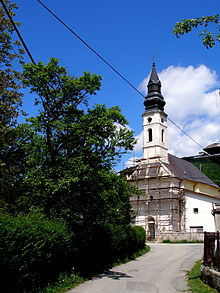
Der Ort ist ein Wallfahrtsort für Anhänger der griechisch-katholischen Kirche in der Slowakei. Hier steht u. a. die einzige griechisch-katholische Basilica minor in der Slowakei.
Weblinks
Bajerovce (Baierhau) | Bodovce | Brezovica | Brezovička (Hamburg) | Červená Voda | Červenica pri Sabinove | Daletice | Drienica | Dubovica | Ďačov | Hanigovce (Hönigsdorf) | Hubošovce | Jakovany | Jakubova Voľa | Jakubovany (Jakobsdorf) | Jarovnice (Jarownitz) | Kamenica | Krásna Lúka (Schönwies) | Krivany | Lipany (Siebenlinden) | Lúčka | Ľutina | Milpoš | Nižný Slavkov (Unterschlauch) | Olejníkov (Holenitz) | Oľšov | Ostrovany | Pečovská Nová Ves (Frauendorf) | Poloma | Ratvaj | Ražňany | Renčišov | Rožkovany | Sabinov (Zeben) | Šarišské Dravce | Šarišské Michaľany | Šarišské Sokolovce | Tichý Potok (Stellbach) | Torysa | Uzovce | Uzovské Pekľany | Uzovský Šalgov | Vysoká
Wikimedia Foundation.


