Chaudière-Appalaches

Chaudière-Appalaches
Lage der Region Chaudière-Appalaches in Québec
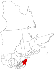
Provinz Québec
Verwaltungssitz Montmagny
Landfläche 15.070,9 km²
Einwohner (2007) 399.563
Bevölkerungsdichte 26,5 Ew./km²

Chaudière-Appalaches ist eine Verwaltungsregion (frz. région administrative) im Südosten der kanadischen Provinz Québec. Sie ist weiter in neun regionale Grafschaftsgemeinden (municipalités régionales de comté) und 136 Gemeinden unterteilt. Sitz der Verwaltung ist Montmagny.

Die Einwohnerzahl beträgt 399.563 (2007), die Landfläche 15.070,9 km², was einer Bevölkerungsdichte von 26,5 Einwohnern je km² entspricht. 99,8 % der Einwohner sprechen Französisch und 0,1 % Englisch als Hauptsprache.

Im Osten grenzt Chaudière-Appalaches an den US-Bundesstaat Maine, im Süden an die Region Estrie, im Westen an Centre-du-Québec, im Nordwesten an Capitale-Nationale, im Nordosten an Bas-Saint-Laurent.

Gliederung

Regionale Grafschaftsgemeinden (MRC):

Gemeinde außerhalb einer MRC:

Weblinks


Wikimedia Foundation.

Игры ⚽ Нужно решить контрольную?

Schlagen Sie auch in anderen Wörterbüchern nach:

  • Chaudiere-Appalaches — Chaudière Appalaches Pour les articles homonymes, voir Chaudière (homonymie). Localisation de la région de Chaudière Appalaches dans la province de Québec …   Wikipédia en Français

  • Chaudière–Appalaches — Chaudière Appalaches Pour les articles homonymes, voir Chaudière (homonymie). Localisation de la région de Chaudière Appalaches dans la province de Québec …   Wikipédia en Français

  • Chaudière—Appalaches — Pour les articles homonymes, voir Chaudière (homonymie). Localisation de la région de Chaudière Appalaches dans la province de Québec …   Wikipédia en Français

  • Chaudière-Appalaches — Chaudière AppalachesChaudière Appalaches Región de  Canadá Mapa …   Wikipedia Español

  • Chaudiere-Appalaches — Chaudière Appalaches Provinz Québec Verwaltungssitz Montmagny …   Deutsch Wikipedia

  • Chaudière-Appalaches — région admin. du Québec située au S. de la région admin. de Québec et entre les rég. admin. Mauricie Bois Francs et Estrie, à l O., et Bas Saint Laurent, à l E.; 15 031 km²; 380 000 hab …   Encyclopédie Universelle

  • Chaudière-Appalaches — 46°29′N 70°37′W / 46.483, 70.617 …   Wikipédia en Français

  • Chaudière-Appalaches — Map of Quebec showing Chaudière Appalaches in red Chaudière Appalaches is an administrative region in Quebec, Canada. It comprises most of what is historically known as the Beauce (French: La Beauce; compare with the electoral district of Beauce) …   Wikipedia

  • Chaudiere-Appalaches — Admin ASC 2 Code Orig. name Chaudière Appalaches Country and Admin Code CA.10.12 CA …   World countries Adminstrative division ASC I-II

  • PÔLE Québec Chaudière-Appalaches — est l organisme de développement économique international des régions québécoises de Québec et de Chaudière Appalaches. Il a été créé sous sa forme actuelle en 2003 pour donner suite à un rapport sur le développement économique de la région… …   Wikipédia en Français

Share the article and excerpts

Direct link
Do a right-click on the link above
and select “Copy Link”