Van Phong Port

Van Phong Port

BW

Van Phong Port
Daten
Ort Vịnh Vân Phong
Land VietnamVietnam Vietnam
Provinz Khánh Hòa
Baubeginn 31. Oktober 2009
Kosten 3,6 Billion US-Dollar
Hafentyp Tiefwasser- und Transshipmenthafen
Koordinaten 12° 40′ 0″ N, 109° 17′ 0″ O12.666666666667109.283333333330Koordinaten: 12° 40′ 0″ N, 109° 17′ 0″ O
Van Phong Port (Vietnam)
Van Phong Port
Lage Van Phong Port

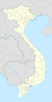
Der Van Phong Port ist ein im Bau befindlicher Tiefwasser- und Transshipmenthafen nördlich von Nha Trang in Vietnam.

Inhaltsverzeichnis

Geographie

Die Van Phong Bucht (Vịnh Vân Phong) hat eine natürliche Wassertiefe von 22 bis 27 Metern und ist durch die Hòn Gốm Halbinsel vor Seegang und Dünung geschützt.[1] Keine andere Bucht entlang der vietnamesischen Küste hat ähnlich gute Voraussetzungen für einen Tiefwasserhafen.[2]

Geschichte

Mit dem ersten Bauabschnitt, er hat am 31. Oktober 2009 begonnen, werden 2 Piers zur Abfertigung von Containerschiffen bis zu 9.000 TEU und einem Tiefgang bis zu 16,5 Metern erstellt. In zwei weiteren Ausbauabschnitten sollen Einrichtungen zur Aufnahme von Containerschiffen mit 17.000 TEU und mehr geschaffen werden.[3]

Waren und Verkehr

Nach der Fertigstellung wird Van Phong Port der führende internationale Seehafen Vietnams sein. Aufgrund seiner unmittelbaren Lage entlang des Hauptschifffahrtsweges im Südchinesischen Meer wird er die Lücke zwischen den Transshipmenthäfen Singapur und Hong Kong schließen und an Bedeutung gewinnen.

Einzelnachweise

  1. Baubeginn auf Vietnewsonline (Englisch) (abgerufen am 3. Mai 2011)
  2. Baubeginn auf Look at Vietnam (Englisch) (abgerufen am 3. Mai 2011)
  3. Bauabschnitte auf Vietnam Industrial Parks News (Englisch) (abgerufen am 3. Mai 2011)

Wikimedia Foundation.

Игры ⚽ Поможем написать курсовую

Schlagen Sie auch in anderen Wörterbüchern nach:

  • Phong Nha-Ke Bang National Park — Infobox World Heritage Site WHS = Phong Nha Ke Bang National Park State Party = VIE Type = Natural Criteria = viii ID = 951 Region = Asia Pacific Year = 2003 Session = 27th Link = http://whc.unesco.org/en/list/951Infobox protected area | name =… …   Wikipedia

  • Hai Phong — Infobox Settlement name = Hải Phòng official name = other name = native name = nickname = settlement type = Provincial city total type = motto = imagesize = 300px image caption = A street in Hai Phong flag size = image seal size = image shield =… …   Wikipedia

  • Da Nang Port — Location Country Vietnam …   Wikipedia

  • Roman Catholic Diocese of Hai Phòng — The diocese of Hai Phòng (Latin: Dioecesis Haiphongensis) is a Roman Catholic diocese in northern Vietnam. The bishop is Joseph Vu Van Thien, since 2002. The creation of the diocese in present form was declared November 24, 1960. The earliest… …   Wikipedia

  • Nha Trang — Thành phố Nha Trang …   Wikipedia

  • List of deep-water ports — A deep water port is any port that can accommodate a fully laden Panamax ship. With the approval of the Panama Canal expansion proposal in October, 2006, this list will need to be significantly revised when the expansion is completed. Contents 1… …   Wikipedia

  • Phu Yen Province — Infobox province of Vietnam Name = Phú Yên | rdg Meaning = Rich and Sound Party Secretary = Đào tấn Lộc Committee Chairman = Phạm Ngọc Chi Capital = Tuy Hòa Region = South Central Coast Area = 5,045.3 km Population = 848,900 Population year =… …   Wikipedia

  • Flughafen Dong Tac — Sân bay Đông Tác BW …   Deutsch Wikipedia

  • Nam Trung Bộ — Coordinates: 15°41′49.51″N 108°25′26.66″E / 15.6970861°N 108.4240722°E / 15.6970861; 108.4240722 …   Wikipedia

  • Khanh Hoa Province — Infobox province of Vietnam Name = Khánh Hòa Meaning = Council Chair = Mai Trực Committee Chair = Võ Lâm Phi Capital = Nha Trang Region = South Central Coast Area = 5,197 Population = 1,080,800 Population year = 2004 Population density = 257.5… …   Wikipedia

Share the article and excerpts

Direct link
Do a right-click on the link above
and select “Copy Link”