- County Laois
-
County Laois
Contae LaoiseKarte 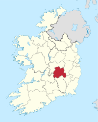
Basisdaten Staat: Irland Verwaltungssitz: Portlaoise Provinz: Leinster irischer Name: Laois Fläche: 1719 km² Einwohner: 80.458 (2011) Kfz-Kennzeichen: LS Laois (etwa Liesch ausgesprochen, irisch: Laois; frühere englische Bezeichnung Leix) ist eine Grafschaft (county) in der Republik Irland.
Inhaltsverzeichnis
Geografie
Im Osten von Laois liegt das Flachland des (Flusses) Barrow, im Nordwesten liegen die Slieve Bloom Mountains mit dem 486 Meter hohen Baureigh Mountain als höchster Erhebung des Countys. Etwa 60% der Fläche sind Weideland, der Rest teilt sich in Ackerland und Hochmoore auf.
Geschichte
Der frühere englische Name des Countys ist "Leix". Es gehörte im Mittelalter zum Königreich Leinster. 1171 wurde das Gebiet von den Anglonormannen erobert und fiel 1460 an England. 1556 wurde die Grafschaft unter dem Namen "Queen's County" gebildet und die Besiedlung des Landes mit englischen Siedlern betrieben.
Wirtschaft
Die Landwirtschaft besteht aus Schaf-, Schweine- und Geflügelhaltung. Des Weiteren gibt es Holz- und Nahrungsmittelindustrie.
Politik
Laois bildet zusammen mit dem County Offaly einen Wahlkreis, der fünf Abgeordnete in das irische Parlament (Dáil Éireann) entsendet; die letzte Wahl fand 2011 statt.
Die Sitzverteilung im County Council nach der Kommunalwahl vom 5. Juni 2009:
Partei Sitze Fine Gael 12 Fianna Fáil 8 Labour Party 1 Sinn Féin 1 Parteilose 3 Städte
- Portlaoise
- Portarlington
- Mountmellick
- Abbeyleix
- Mountrath
- Stradbally
- Rathdowney
- Durrow
- Ballylynan
- Emo
Sehenswürdigkeiten
- Rock of Dunamase
- Coolhanaghar Church
- Emo Court, neoklassizistisches Herrenhaus aus dem frühen 19. Jahrhundert
- Timahoe, Rundturm
Weblinks
 Commons: County Laois – Album mit Bildern und/oder Videos und Audiodateien
- Offizielle Website (englisch)
- Tourismus in Laois (englisch)
 Grafschaften (Countys) der Republik Irland
Carlow | Cavan | Clare | Cork | Donegal | Dublin | Galway | Kerry | Kildare | Kilkenny | Laois | Leitrim | Limerick | Longford | Louth | Mayo | Meath | Monaghan | Offaly | Roscommon | Sligo | Tipperary | Waterford | Westmeath | Wexford | Wicklow
Wikimedia Foundation.
Schlagen Sie auch in anderen Wörterbüchern nach:
County Laois — Contae Laoise Coat of arms Motto: I bp … Wikipedia
Portarlington, County Laois — Portarlington Cúil an tSúdaire Town Portarlington train station … Wikipedia
Durrow, County Laois — Durrow Darú / Darmhagh Ua nDuach Town View of Durrow … Wikipedia
Donaghmore, County Laois — Donaghmore An Domhnach Mór Town Donaghmore on the River Erkina … Wikipedia
The Swan, County Laois — Infobox Irish Place name = The Swan gaeilge = An Eala crest motto = map pin coords = left: 75px; top: 73px north coord = 52.888828 west coord = 07.160244 irish grid = S563825 area = elevation = province = Leinster county = County Laois town pop … Wikipedia
Oughaval (County Laois) — Oughaval (Nuachongbáil), County Laois, Ireland, sometimes called Oakvale, is a townland within the present day parish of Stradbally and is the site of a sixth century monastic settlement. Contents 1 Monastery 2 Oughaval Wood 3 Township history … Wikipedia
Raheen, County Laois — This article is about Raheen, a village in County Laois. For other places called Raheen, see Raheen, County Limerick, Raheen, County Wexford, or Raheen (estate). Infobox Irish Place name = Raheen gaeilge = An Ráithín crest motto = map pin coords … Wikipedia
Castletown, County Laois — Infobox Irish Place name = Castletown gaeilge = temp crest motto = map pin coords = left: 83px; top: 71px north coord = west coord = irish grid = area = elevation = province = Leinster county = County Laois town pop = rural pop = census yr = web … Wikipedia
Newtown, County Laois — Newtown on the R430 Newtown Cross on the N78 New … Wikipedia
New Inn, County Laois — New Inn Town … Wikipedia
County Laois

18+
© Academic, 2000-2026
- Kontaktieren Sie uns: Unterstützung, Werbung
Wörterbücher Export, schritte mit PHP, Joomla, Drupal, WordPress, MODx.