- County Cavan
-
County Cavan
Contae an ChabháinKarte 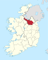
Basisdaten Staat: Irland Verwaltungssitz: Cavan Provinz: Ulster irischer Name: An Cabhán Fläche: 1.932 km² Einwohner: 72.874 (2011) Kfz-Kennzeichen: CN Cavan (ir. An Cabhán /əN ˈkawaːN/) ist eine Grafschaft (county) in der Republik Irland, die zu Zeiten von Elisabeth I. von England gegründet wurde. Cavan ist eine von drei Grafschaften, die in der Provinz von Ulster liegen, ohne Nordirland anzugehören.
Inhaltsverzeichnis
Geografie
Das Gebiet gehört zur irischen Drumlin-Region und ist mit vielen Mooren und Seen bedeckt. Es grenzt innerhalb der Republik Irland an Monaghan, Leitrim, Longford, Meath und Westmeath sowie an Fermanagh in Nordirland.
Wirtschaft
Die Landwirtschaft besteht in der Hauptsache aus Rinderhaltung.
Städte
- Cavan (Hauptstadt)
- Arva
- Bailieborough, Ballinagh, Ballyconnell, Ballyhaise, Ballyjamesduff, Bawnboy, Belturbet, Blacklion, Butlersbridge
- Cootehill
- Dowra, Glangevlin
- Kingscourt, Killeshandra
- Mullagh
- Stradone, Shercock
- Virginia
Sehenswürdigkeiten
- Burren Wedge tomb
- Cohaw Court tomb
- Drumlane Church and Round Tower
- Cabra Castle in Kingscourt
- Magh Slécht
- Terry Coyle Park
Geschichte
Cavan bildete den Ostteil des Königreichs Breifne.
Politik
Die Sitzverteilung im Cavan County Council nach der Kommunalwahl vom 5. Juni 2009:
Partei Sitze Fine Gael 13 Fianna Fáil 8 Sinn Féin 4 Weblinks
 Grafschaften (Countys) der Republik Irland
Carlow | Cavan | Clare | Cork | Donegal | Dublin | Galway | Kerry | Kildare | Kilkenny | Laois | Leitrim | Limerick | Longford | Louth | Mayo | Meath | Monaghan | Offaly | Roscommon | Sligo | Tipperary | Waterford | Westmeath | Wexford | Wicklow
Wikimedia Foundation.
Schlagen Sie auch in anderen Wörterbüchern nach:
County Cavan — Contae an Chabháin Coat of arms Motto … Wikipedia
Mullagh, County Cavan — Mullagh An Mullach Town … Wikipedia
Virginia, County Cavan — Infobox Irish Place name = Virginia gaeilge = Achadh an Iúir crest motto = map pin coords = left: 109px; top: 69px north coord = 53.833333 west coord = 7.0833337 irish grid = N604876 area = elevation = 113 m (379 ft) province = Ulster county =… … Wikipedia
Milltown, County Cavan — Milltown Baile an Mhuilinn Town … Wikipedia
Doon, County Cavan — Doon is a townland in the Parish of Tomregan, Barony of Tullyhaw, County Cavan, Ireland. The townland name is an anglicisation of the Gaelic placename “Dún” which means ‘A fort’. The oldest surviving mention of the name is in the 1609 Ulster… … Wikipedia
Clifton, County Cavan — Clifton is a townland in the Parish of Tomregan, Barony of Loughtee Lower, County Cavan, Ireland. The townland name is an anglicisation of the Gaelic placename “Clochán” which means ‘A small beehive shaped stone house”. It is bounded on the north … Wikipedia
Stradone, County Cavan — Stradone (Irish place name|Sraith an Domhain|Recess of the Spider) is identified in the current County Cavan, Ireland, Development Plan 2003 2009 as a smaller urban community. These small communities are recognised as having what could be… … Wikipedia
Fartha, County Cavan — Fartha is a small townland in the south eastern side of County Cavan, Ireland. It consists of 146 statute acres and is convert|657|ft|m at its highest point. It is made up mostly of green area and has a convert|4.5|acre|m2|sing=on lake known as… … Wikipedia
Cavan (UK Parliament constituency) — Cavan Former County constituency for the House of Commons 1801 (1801)–1885 (1885) … Wikipedia
Cavan County (Parliament of Ireland constituency) — Cavan Former County constituency Created () Post Union Cavan Type Irish House of Commons Cavan County was a constituency represented in the Irish House of Commons from 1611 to 1800. Between 1725 and 1793 Catholics and those married to… … Wikipedia
County Cavan

18+
© Academic, 2000-2026
- Kontaktieren Sie uns: Unterstützung, Werbung
Wörterbücher Export, schritte mit PHP, Joomla, Drupal, WordPress, MODx.