- County Waterford
-
County Waterford
Contae Phort LáirgeKarte 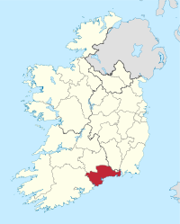
Basisdaten Staat: Irland Verwaltungssitz: Dungarvan Provinz: Munster irischer Name: Contae Phort Láirge Fläche: 1859 km² Einwohner: 113.707 (2011) Kfz-Kennzeichen: W (Stadt) / WD (County) Waterford (irisch Port Láirge) ist eine Grafschaft (County) im Süden der Republik Irland.
Inhaltsverzeichnis
Geografie
Im Norden wird das County durch den Fluss Suir, im Osten durch den Waterford Harbour begrenzt. Der Westen ist geprägt von einem Berg- und Hügelland, der Osten ist eher Flachland.
Geschichte
Im frühen Mittelalter gehörte das Gebiet zum Königreich Leinster. 1172 wurde das Gebiet von den Anglonormannen erobert. Im 13. Jahrhundert erfolgte die Gründung der Grafschaft.
Politik
Die Sitzverteilung im County Council nach der Kommunalwahl vom 5. Juni 2009:
Partei Sitze Fine Gael 11 Fianna Fáil 5 Labour Party 4 Sinn Féin 2 Parteilose 1 Städte
Der Verwaltungssitz des Countys ist Dungarvan.
- Dungarvan
- Tramore
- Dunmore East
- Portlaw
- Lismore
Sehenswürdigkeiten
- Ardmore (Irland) Rundturm
- Ballynamona Lower Court tomb
- Carriglong Passage tomb
- Gaulstown Portal tomb
- Harristown Passage tomb
- Knockeen Portal tomb
- Munmahogue Wedge tomb
 Grafschaften (Countys) der Republik Irland
Carlow | Cavan | Clare | Cork | Donegal | Dublin | Galway | Kerry | Kildare | Kilkenny | Laois | Leitrim | Limerick | Longford | Louth | Mayo | Meath | Monaghan | Offaly | Roscommon | Sligo | Tipperary | Waterford | Westmeath | Wexford | Wicklow
Wikimedia Foundation.
Schlagen Sie auch in anderen Wörterbüchern nach:
County Waterford — Contae Phort Láirge Coat of arms Mot … Wikipedia
County Waterford (UK Parliament constituency) — Not to be confused with Waterford City (UK Parliament constituency). Waterford Former County constituency for the House of Commons 1801 (1801)–1885 ( … Wikipedia
Tallow, County Waterford — Tallow ( Tulach an Iarainn in Irish) is a small town in west County Waterford, Ireland, situated near the County Cork border. It is on the road between Lismore, County Waterford and Youghal.port*Tallow GAA is the local Gaelic Athletic Association … Wikipedia
Lismore, County Waterford — Infobox Irish Place name = Lismore gaeilge = Lios Mór crest motto = map pin coords = left: 35px; top: 60px north coord = 52.1367 | west coord = 7.9308 | irish grid = X045984 area = | elevation = 86 m (285 ft) province = Munster county = Waterford … Wikipedia
Ring, County Waterford — Infobox Irish Place name = Ring gaeilge = An Rinn crest motto = map pin coords = left: 80px; top: 78px north coord = 52.0500 west coord = 7.5833 irish grid = X259930 area = elevation = province = Munster county = Waterford town pop = rural pop =… … Wikipedia
Ardmore, County Waterford — Ardmore (Irish place name|Aird Mhór|Great Height) is a fishing village in County Waterford, Ireland situated not far from Youghal on the south coast of Ireland, with a population of around 330, although this varies with the tourist season. It is… … Wikipedia
Grange, County Waterford — Grange is a small village in the west County Waterford, in Ireland. It borders Ardmore, and these two villages are both members of the Ardmore Grange parish. Amenities The village lies on the N25 road, and consists of an 1835 Roman Catholic… … Wikipedia
Ballyduff, County Waterford — NOTOC Ballyduff ( Irish Baile Dubh ) is a village in County Waterford, Ireland, on the river Blackwater. It lies on the R666 regional road about km to mi | 16 | abbr=yes | precision=0 from the town of Fermoy and km to mi | 10 | abbr=yes |… … Wikipedia
Waterford — Wappen Karte … Deutsch Wikipedia
Waterford County (Parliament of Ireland constituency) — Waterford County Former County constituency Created () Post Union Type Irish House of Commons Waterford County was a constituency represented in the Irish House of Commons until 1800 … Wikipedia
County Waterford

18+
© Academic, 2000-2026
- Kontaktieren Sie uns: Unterstützung, Werbung
Wörterbücher Export, schritte mit PHP, Joomla, Drupal, WordPress, MODx.