- Cranford (New Jersey)
-
Cranford 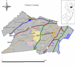 Lage in New Jersey
Basisdaten Staat: Vereinigte Staaten Bundesstaat: New Jersey County: Koordinaten: 40° 39′ N, 74° 18′ W40.656388888889-74.30361111111124Koordinaten: 40° 39′ N, 74° 18′ W Zeitzone: Eastern Standard Time (UTC−5) Einwohner: 22.369 (Stand: 2006) Bevölkerungsdichte: 1.789,5 Einwohner je km² Fläche: 12,5 km² (ca. 5 mi²)
davon 12,5 km² (ca. 5 mi²) LandHöhe: 24 m Postleitzahl: 07016 Vorwahl: +1 908 FIPS: 34-15640 GNIS-ID: 0882214 Webpräsenz: www.cranford.com/township Bürgermeister: Robert Puhak Cranford ist ein Township im Union County, New Jersey, USA. Bei der Volkszählung von 2000 wurde eine Bevölkerungszahl von 22.578 registriert. Cranford wurde im Jahr 1871 gegründet.
Geographie
Nach dem amerikanischen Vermessungsbüro hat die Stadt eine Gesamtfläche von 12,5 km², wovon 12,5 km² Land und 0,1 km² (0,41 %) Wasser ist.
Demographie
Nach der Volkszählung von 2000 gibt es 22.578 Menschen, 8.397 Haushalte und 6.222 Familien in der Stadt. Die Bevölkerungsdichte beträgt 1.808,6 Einwohner pro km². 93,70 % der Bevölkerung sind Weiße, 2,58 % Afroamerikaner, 0,04 % amerikanische Ureinwohner, 2,15 % Asiaten, 0,02 % pazifische Insulaner, 0,67 % anderer Herkunft und 0,84 % Mischlinge. 3,89 % sind Latinos unterschiedlicher Abstammung.
Von den 8.397 Haushalten haben 32,9 % Kinder unter 18 Jahre. 63,0 % davon sind verheiratete, zusammenlebende Paare, 8,8 % sind alleinerziehende Mütter, 25,9 % sind keine Familien, 21,9 % bestehen aus Singlehaushalten und in 10,2 % Menschen sind älter als 65. Die Durchschnittshaushaltsgröße beträgt 2,62, die Durchschnittsfamiliegröße 3,09.
23,3 % der Bevölkerung sind unter 18 Jahre alt, 5,3 % zwischen 18 und 24, 29,4 % zwischen 25 und 44, 24,1 % zwischen 45 und 64, 17,9 % älter als 65. Das Durchschnittsalter beträgt 40 Jahre. Das Verhältnis Frauen zu Männer beträgt 100:90,5, für Menschen älter als 18 Jahre beträgt das Verhältnis 100:86,2.
Das jährliche Durchschnittseinkommen der Haushalte beträgt 76.338 USD, das Durchschnittseinkommen der Familien 86.624 USD. Männer haben ein Durchschnittseinkommen von 60.757 USD, Frauen 41.020 USD. Der Prokopfeinkommen der Stadt beträgt 33.283 USD. 2,5 % der Bevölkerung und 1,0 % der Familien leben unterhalb der Armutsgrenze, davon sind 1,5 % Kinder oder Jugendliche jünger als 18 Jahre und 6,3 % der Menschen sind älter als 65.

Wikimedia Foundation.