Erith

Erith
London Borough of Bexley
Bexley
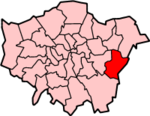
Lage in Greater London
Status London Borough
Region Greater London
Verwaltungssitz Bexleyheath
Fläche 60,56 km² (289.)
Einwohner (2007) 220.100 (56.)
ONS-Code 00AD
Website www.bexley.gov.uk

London Borough of Bexley [ˈbɛksli] ist ein Stadtbezirk von London und liegt im Osten der Stadt. Bei der Gründung von Greater London im Jahr 1965 wurde er aus folgenden Gemeinden der Grafschaft Kent gebildet: Bexley, Crayford, Erith sowie etwa die Hälfte von Chislehurst and Sidcup.

Partnerstädte sind Arnsberg und Évry. Die Bevölkerung setzt sich aus 91,4 % Weißen, 3,4 % Südasiaten und 2,9 % Schwarzen zusammen.

Stadtteile

  • Albany Park
  • Barnehurst
  • Barnes Cray
  • Belvedere
  • Bexley
  • Bexleyheath
  • Blackfen
  • Blendon
  • Bostall
  • Bridgen
  • Coldblow
  • Crayford
  • Crook Log
  • East Wickham
  • Erith
  • Falconwood
  • Foots Cray
  • Lamorbey
  • Lessness Heath
  • Longlands
  • May Place
  • North Cray
  • North End
  • Northumberland Heath
  • Old Bexley
  • Sidcup
  • Slade Green
  • Thamesmead
  • Upper Belvedere
  • Upton
  • Welling
  • West Heath

Persönlichkeiten

Weblinks


Wikimedia Foundation.

Игры ⚽ Нужно сделать НИР?

Schlagen Sie auch in anderen Wörterbüchern nach:

  • Erith — Erith, Stadt in der engl. Grafschaft Kent, rechts an der Themse, 7 km östlich von Woolwich, hübsch gelegen, Sommerfrische der Londoner, mit Kasino, Anlagen, Gewehrfabrik, Ziegeleien, Fabrikation von Leim, künstlichem Dünger etc. und (1901) 25,295 …   Meyers Großes Konversations-Lexikon

  • Erith — (spr. ihr ), Stadt in der engl. Grafsch. Kent, an der Themse, (1901) 25.295 E …   Kleines Konversations-Lexikon

  • erith — erith·a·cus; …   English syllables

  • Erith — infobox UK place country = England map type = Greater London region= London population= official name= Erith latitude= 51.4763 longitude= 0.1681 london borough= Bexley constituency westminster= Erith Thamesmead constituency westminster1=… …   Wikipedia

  • Erith — Original name in latin Erith Name in other language Erith State code GB Continent/City Europe/London longitude 51.48315 latitude 0.17484 altitude 8 Population 9811 Date 2012 06 01 …   Cities with a population over 1000 database

  • Erith (disambiguation) — Erith may refer to:* Erith, London * Erith Island (Tasmania) * Raymond Erith (1904 1973), English architect * [http://www.erith.net/ The Erith Group] Construction services company based in Erith South East London …   Wikipedia

  • Erith Marshes — is an area of grazing marsh beside the south bank of River Thames in London, England.It is located next to the Crossness Sewage Treatment Works and is owned by Thames Water.London Wildweb [http://www.london.gov.uk/wildweb/PublicSiteViewFull.do?pic… …   Wikipedia

  • Erith Island (Tasmania) — Erith Island is a granite island, with an area of 323 ha, in south eastern Australia. It is the second largest of Tasmania’s Kent Group, lying in northern Bass Strait between the Furneaux Group and Wilsons Promontory in Victoria. It is now part… …   Wikipedia

  • Erith and Crayford (UK Parliament constituency) — Erith and Crayford was a parliamentary constituency in the London Borough of Bexley, south east London.It returned one Member of Parliament to the House of Commons of the Parliament of the United Kingdom from 1955 until it was abolished for the… …   Wikipedia

  • Erith Playhouse — Infobox Theatre name = Erith Playhouse caption = Fill image address = High Street city = Erith, London Borough of Bexley country = designation = latitude = 51.4763 longitude = 0.1681 architect = owner = Erith Theatre Guild capacity = 195 seats… …   Wikipedia

Share the article and excerpts

Direct link
Do a right-click on the link above
and select “Copy Link”