- Farm Loop
-
Farm Loop 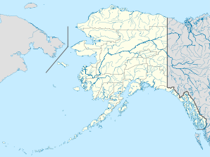

Farm Loop Lage in AlaskaBasisdaten Staat: Vereinigte Staaten Bundesstaat: Alaska Koordinaten: 61° 38′ N, 149° 9′ W61.628333333333-149.14555555556Koordinaten: 61° 38′ N, 149° 9′ W Zeitzone: Alaska Standard Time (UTC−9) Einwohner: 1067 (Stand: 2000) Bevölkerungsdichte: 46,6 Einwohner je km² Fläche: 22,9 km² (ca. 9 mi²)
davon 22,9 km² (ca. 9 mi²) LandVorwahl: +1 907 FIPS: 02-25000 GNIS-ID: 2418580 Farm Loop ist ein census-designated place (CDP) im Matanuska-Susitna Borough in Alaska in den Vereinigten Staaten. Das Gebiet liegt im Zentrum des Matanuska-Susitna-Tales nördlich der Stadt Palmer und ist über den Glenn Highway, die Farm Loop Road und die Willow-Fishhook Road erreichbar.
Geschichte
Das ganze Matanuska-Susitna-Tal war als eine geplante landwirtschaftliche Kolonie angelegt. 203 Familien, die meisten aus Michigan, Wisconsin and Minnesota, zogen 1935 in das Gebiet. Viele ihrer Nachfahren leben immer noch dort. Geringe Wohnungskosten, der ländliche Lebensstil sowie die Nähe zur Großstadt Anchorage begünstigten das Bevölkerungswachstum.
Demografie
Zum Zeitpunkt der Volkszählung im Jahre 2000 (U.S. Census 2000) hatte Farm Loop CDP 1.067 Einwohner auf einer Landfläche von 22,9 km². Das Durchschnittsalter betrug 33,7 Jahre (nationaler Durchschnitt der USA: 35,3 Jahre). Das Pro-Kopf-Einkommen (engl. per capita income) lag bei US-Dollar 20.880 (nationaler Durchschnitt der USA: US-Dollar 21.587). 7,2% der Einwohner lagen mit ihrem Einkommen unter der Armutsgrenze (nationaler Durchschnitt der USA: 12,4%).[1]33,1% der Einwohner sind deutschstämmig, 22,4% sind englischer- und 18,1% irischer Abstammung. Viele Einwohner arbeiten in Palmer, Wasilla und Anchorage.
Einzelnachweise
Weblinks
- Datenbank der Gemeinden Alaskas: Farm Loop (englisch)
- Statistiken über Farm Loop bei city-data.com (englisch)
Städte und Census-designated places im Matanuska-Susitna BoroughBig Lake | Buffalo Soapstone | Butte | Chase | Chickaloon | Farm Loop | Fishhook | Gateway | Glacier View | Houston | Knik River | Knik-Fairview | Lake Louise | Lakes | Lazy Mountain | Meadow Lakes | Palmer | Petersville | Point MacKenzie | Skwentna | Susitna | Sutton-Alpine | Talkeetna | Tanaina | Trapper Creek | Wasilla | Willow | Y
Wikimedia Foundation.
Schlagen Sie auch in anderen Wörterbüchern nach:
Farm Loop — Farm Loop, AK U.S. Census Designated Place in Alaska Population (2000): 1067 Housing Units (2000): 350 Land area (2000): 8.842000 sq. miles (22.900673 sq. km) Water area (2000): 0.011513 sq. miles (0.029818 sq. km) Total area (2000): 8.853513 sq … StarDict's U.S. Gazetteer Places
Farm Loop, AK — U.S. Census Designated Place in Alaska Population (2000): 1067 Housing Units (2000): 350 Land area (2000): 8.842000 sq. miles (22.900673 sq. km) Water area (2000): 0.011513 sq. miles (0.029818 sq. km) Total area (2000): 8.853513 sq. miles… … StarDict's U.S. Gazetteer Places
Farm Loop — Original name in latin Farm Loop Name in other language State code US Continent/City America/Anchorage longitude 61.63891 latitude 149.14215 altitude 151 Population 1028 Date 2011 05 14 … Cities with a population over 1000 database
Farm Loop (Alaska) — 61° 37′ 42″ N 149° 08′ 44″ W / 61.628333, 149.145556 … Wikipédia en Français
Farm Loop, Alaska — Infobox Settlement official name = Farm Loop, Alaska settlement type = CDP nickname = motto = imagesize = image caption = image |pushpin pushpin label position =left pushpin map caption =Location within the state of Alaska pushpin mapsize =… … Wikipedia
Farm to Market Road 865 — Route information Length: 10.11 mi[1] (16.27 km) … Wikipedia
Farm to Market Road 188 — Farm to Market Road 188, also known as Teichman Road, is a Farm to Market Road located in Galveston, Texas. At only 1 mile long it is one of the shortest farm to market roads in Texas. Only one exit sign on I 45 shows Teichman Rd as FM 188 and it … Wikipedia
Farm to Market Road 734 — Infobox TX State Highway type=Farm route=734 length mi=19.284 length ref=cite web | author=Texas Department of Transportation | title=Highway Designation File Farm to Market Road 734 | url=http://www.dot.state.tx.us/tpp/hwy/fm0500/fm0734.htm |… … Wikipedia
Farm to Market Road 1325 — Infobox TX State Highway type=Farm route=1325 length mi=7.185 length ref=TxDOT|UR|1325] length km=11.56 formed=1949TxDOT|FM|1325] dir1=South dir2=North from=jct|state=TX|US|183 in Austin junction= (Mopac Expressway) to=jct|state=TX|Toll|45 in… … Wikipedia
Farm to Market Road 989 — Infobox TX State Highway route=989 type=Farm length mi=11.84Texas Department of Transportation, [http://www.dot.state.tx.us/tpp/hwy/fm0500/fm0989.htm] ] length km=19.05 formed=1948 dir1=North dir2=South from= junction= |to= previous route=988… … Wikipedia
Farm Loop

18+
© Academic, 2000-2026
- Kontaktieren Sie uns: Unterstützung, Werbung
Wörterbücher Export, schritte mit PHP, Joomla, Drupal, WordPress, MODx.