- Grand-Santi
-
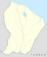
Grand-Santi Region Französisch-Guayana Département Französisch-Guayana Arrondissement Saint-Laurent-du-Maroni Kanton Maripasoula Gemeindeverband Communauté de communes de l'Ouest guyanais Koordinaten 4° 16′ N, 54° 23′ W4.2727777777778-54.3860Koordinaten: 4° 16′ N, 54° 23′ W Höhe 60 m (40–464 m) Fläche 2.112,00 km² Einwohner 3.973 (1. Jan. 2008) Bevölkerungsdichte 2 Einw./km² Postleitzahl 97340 INSEE-Code 97357 Grand-Santi ist eine französische Kommune mit 3973 Einwohnern (Stand 1. Januar 2008) im Überseedepartement Französisch-Guayana.
Inhaltsverzeichnis
Geografie
Grand-Santi erstreckt sich südlich der montagne francaise, dem guanesischen Zentralmassiv, entlang des Flusses Lawa (der später in den Maroni mündet). Er ist der einzige Zugang. Die höchsten Erhebungen der Gemeinde bilden der Berg Kotika (730 m) und die montagne francaise (550 m), die gleichzeitig auch Anziehungspunkte sind.
Geschichte
- 1930: Gründung des administrativen Gebiets Inini, das auch Grand-Santi als Verwaltungseinheit enthält
- 1946: Einrichtung Französisch-Guayanas als Überseedepartement, wodurch das administrative Gebiet Inini in ein Arrondissement umgewandelt wird.
- 1968: Gründung des kommunalen Kreises Grand-Santi-Papaichton-Apatou
- 1969: Kommunale Kreise werden in Gemeinden umgewandelt
- 1976: Trennung der Gemeinden Apatou und Grand-Santi-Papaichton
- 1992: Trennung der Gemeinden Papaichton und Grand-Santi
Bevölkerung
Die ca 3.000 Einwohner Grand-Santis sind größtenteils Djukas. Nichtsdestoweniger ließen sich in den 1980er-Jahren Flüchtlinge aus Suriname dort nieder, besonders in den Dörfern Gaa Kaba, Grand Citron, Ana Kondé et Lioni.
Weblinks
Apatou | Awala-Yalimapo | Camopi | Cayenne | Grand-Santi | Iracoubo | Kourou | Macouria | Mana | Maripasoula | Matoury | Montsinéry-Tonnegrande | Ouanary | Papaichton | Régina | Remire-Montjoly | Roura | Saint-Élie | Saint-Georges | Saint-Laurent-du-Maroni | Saül | Sinnamary
Wikimedia Foundation.

