- Gulf Intracoastal Waterway
-
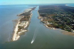 Der Gulf Intracoastal Waterway bei Port Bolivar, Texas
Der Gulf Intracoastal Waterway (GIWW) ist eine Wasserstraße im Süden der Vereinigten Staaten und erstreckt sich entlang des Golf von Mexiko von Brownsville in Texas bis nach Fort Myers an der Westküste von Florida. Er bildet zusammen mit dem Atlantic Intracoastal Waterway, der von Florida bis nach Boston in Massachusetts reicht, den Intracoastal Waterway.
Inhaltsverzeichnis
Geschichte
Im Jahr 1808 entwickelte Finanzminister Albert Gallatin im Auftrag des US-Senats einen Plan für ein gesamtstaatlich finanziertes System von Straßen und Kanälen. Dieser Plan stand im Zeichen der Spannungen zwischen den USA und dem Vereinigten Königreich von Großbritannien und Irland mit seinen Besitzungen auf nordamerikanischem Boden. Da die Seeherrschaft im Nordatlantik fest in britischer Hand lag, sollte ein küstennahes System von Kanälen die US-Küstenstädte per Schiff verbinden. Der Britisch-Amerikanische Krieg von 1812 bis 1814 verdeutlichte dann noch einmal dessen Dringlichkeit.
Während in der zweiten Hälfte des 19. Jahrhunderts der Eisenbahnbau in den USA stark expandierte, verlor die Binnenschifffahrt stark an Bedeutung. Erst ab 1880 entstanden die ersten vereinzelten Kanalbauten, und mit der Inland Waterways Commission, eingesetzt von Präsident Theodore Roosevelt 1907, rückten die Pläne für große, tief ausgebaute Kanäle wieder ins Zentrum der US-Politik. Mit dem Rivers and Harbors Act von 1925 begann der Bau einer durchgängigen, 9 foot (2,7 m) tiefen und 100 foot (30 m) breiten Wasserstraße von New Orleans in Louisiana nach Galveston in Texas. Der große Erfolg der Strecke veranlasste den Kongress bereits 1927, die Verlängerung bis nach Corpus Christi in Texas anzuordnen. Im Jahre 1942 wurde dann die Strecke noch bis nach Brownsville, direkt an der Grenze zu Mexiko, ausgebaut. Die nächste Ausbaustufe war 1962 die Vertiefung auf 16 foot (4,8 m) und Verbreiterung auf stellenweise 200 foot (60 m).
Aufsicht
Der Gulf Intracoastal Waterway wird von fünf Bezirken des Army Corps of Engineers beaufsichtigt. Von Westen nach Osten sind das: der Galveston District, der New Orleans District, der Vicksburg District, der Mobile District und der Jacksonville District.
Häfen
Große Häfen am oder in der Nähe des Gulf Intracoastal Waterway:
- Panama City, Florida
- Pensacola, Florida
- Mobile, Alabama
- Pascagoula, Mississippi
- Gulfport, Mississippi
- New Orleans, Louisiana
- Larose, Louisiana
- Houma, Louisiana
- Morgan City, Louisiana
- Intracoastal City, Louisiana
- Lake Charles, Louisiana
- Port Arthur, Texas
- Galveston, Texas
- Texas City, Texas
- Corpus Christi, Texas
- Brownsville, Texas
Weblinks


Wikimedia Foundation.