- National Highway 1
-
 Verlauf
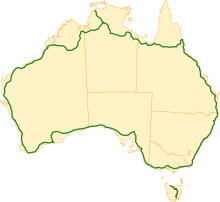
Der National Highway 1, oft auch nur als Highway 1 bezeichnet, ist eine Fernverkehrsstraße in Australien. Der Highway 1 folgt dem Verlauf der Küste und umrundet den gesamten australischen Kontinent. Mit etwa 24.000 Kilometern ist er der längste National Highway weltweit. Der Highway 1 verbindet die Hauptstädte Brisbane, Darwin, Perth, Adelaide, Melbourne und Sydney. Eine eigene Sektion des Highway 1 gibt es auch auf Tasmanien.
Geschichte


1955 wurde in Australien das nationale Straßen-Nummerierungs-System eingeführt. Zu dieser Zeit war der Highway 1 der einzige echte National Highway. Dies bedeutete aber nicht, dass der Highway 1 die jeweils kürzeste Verbindung zwischen zwei Orten darstellt. Viele andere Highways waren zu dieser Zeit nicht mehr als Nebenstraßen des Highway 1.
Einige Straßen, die parallel zum Highway 1 verlaufen, wurden damals als National Route Alternative 1 bezeichnet, auf Straßenschildern als ALT 1 ausgewiesen. Diese konnten als Ausweichstrecke genutzt werden, ohne das man dabei die generelle Fahrtrichtung änderte oder sein Ziel verfehlte.
In den 1990er Jahren wurde in Australien ein neues National Highway System eingeführt. Dabei wurden neue alphanumerische Bezeichnungen für Straßen eingeführt. Dabei werden die Straßen je nach Bedeutung mit den Buchstaben A, B, C, D oder M bezeichnet. Dies hatte zur Folge, dass die Bezeichnung Highway 1 an Bedeutung einbüßte und Strecken, die früher als Alternative 1 ausgewiesen waren, eigene Nummern erhielten.
Heute


Heute ist der Highway 1 nach wie vor ein wichtiger Bestandteil im Netzwerk der australischen Fernstraßen. Seit der Einführung des National Highway Systems in den 1990er Jahren und dessen schrittweiser Umsetzung in den einzelnen Staaten ist der Highway 1 heute größtenteils als A1 oder M1 ausgeschildert. Die ursprüngliche Beschilderung des Highway 1 ist dagegen größtenteils verschwunden.
In den Ballungsräumen der größeren Städte ist der Highway 1 sehr gut ausgebaut und als vier-, teilweise auch sechsspurige Straße befahrbar. Im Gegensatz dazu stehen einige Regionen in den ländlichen Gegenden des Northern Territory, auf welchen der Highway 1 eine unbefestigte Schotterpiste und nur mit Allradfahrzeugen zu befahren ist.
Verlauf
Verlauf des National Highway 1 in Australien beginnend von Brisbane entgegen dem Uhrzeigersinn:
Staat / Territorium Von Nach Highway / Straße Beschilderung Queensland Brisbane Cairns Bruce Highway 
Cairns Smithfield Captain Cook Highway 

Smithfield Forty-Mile-Scrub-Nationalpark Kennedy Highway 
Forty-Mile-Scrub-Nationalpark Normanton Gulf Developmental Road Queensland / Northern Territory Normanton Borroloola Savannah Way Borroloola Daly Waters Carpentaria Highway Daly Waters Darwin Stuart Highway 
Darwin Katherine Stuart Highway Northern Territory / Western Australia Katherine Wyndham Victoria Highway 
Wyndham Port Hedland Great Northern Highway 
Port Hedland Geraldton North West Coastal Highway Geralton Perth Brand Highway Perth Mandurah Kwinana Freeway 
Mandurah Bunbury Old Coast Road 
Bunbury Walpole South Western Highway 
Walpole Esperance South Coast Highway Esperance Norseman Coolgardie-Esperance Highway Western Australia / South Australia Norseman Port Augusta Eyre Highway Port Augusta Port Wakefield Princes Highway 
Port Wakefield Adelaide Port Wakefield Road South Australia / Victoria Adelaide Melbourne Princes Highway Victoria / New South Wales Melbourne Sydney Princes Highway New South Wales / Queensland Sydney Brisbane Pacific Highway Tasmanien Burnie Devonport Bass Highway Devonport Launceston Bass Highway Launceston Granton Midland Highway Granton Hobart Brooker Highway


Wikimedia Foundation.