- National West Coast Recreation Area
-
Nationales Erholungsgebiet Westküste IUCN-Kategorie III 
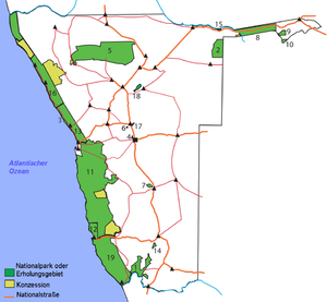
Lage: Namibia Geographische Lage: 22° 7′ S, 14° 17′ O-22.11972222222214.2875Koordinaten: 22° 7′ 11″ S, 14° 17′ 15″ O Fläche: 7445.95 km² Einrichtungsdatum: Verwaltungsbehörde: Ministerium für Umwelt und Tourismus 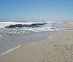
Das Nationale Erholungsgebiet Westküste (Englisch: National West Coast (Tourist) Recreation Area) ist ein Naherholungs- und Naturschutzgebiet in der Namib-Wüste, das nördlich der Stadt Swakopmund/Namibia zwischen den beiden Naturschutzgebieten Naturpark Skelettküste im Norden und Namib-Naukluft-Nationalpark im Süden liegt. Das Erholungsgebiet Westküste ist ca. 200 km lang und rund 50 km breit und wird von der gut ausgebauten Küstenstraße C34 durchzogen. Über sie erreicht man die inzwischen zu einer Stadt erwachsene ehemalige Feriensiedlung Hentiesbucht und die berühmte Robbenkolonie am Kreuzkap sowie zahlreiche Anglerstützpunkte entlang der Küstenlinie bis Kap Frio.
Obwohl das Naturschutzgebiet zur Wüste gehört, sorgt der kalte Benguelastrom regelmäßig für eine allmorgendliche Nebelwand, die weit in das Landesinnere hineinreicht und die spärliche Fauna und Flora mit dem lebensnotwendigen Nass versorgt.

Nationalparks: Bwabwata | Caprivi | Diamantensperrgebiet | Etosha | Fischfluss-Canyon | Khaudom | Mamili | Moremi | Mudumu | Namib-Naukluft
Reservate & Wildparks: Daan Viljoen | Kreuzkap | Mahango | Mangetti | Namib-Rand | Popafälle | Skelettküste | Waterberg
Erholungsgebiete: von Bach | Diamantenküste | Gross Barmen | Hardap | Naute | Westküste


Wikimedia Foundation.