- San’yō-Onoda
-
San’yō-Onoda-shi
山陽小野田市

Geographische Lage in Japan Region: Chūgoku Präfektur: Yamaguchi Koordinaten: 34° 0′ N, 131° 11′ O34.003138888889131.18196111111Koordinaten: 34° 0′ 11″ N, 131° 10′ 55″ O Basisdaten Fläche: 132,94 km² Einwohner: 64.276
(1. Juli 2011)Bevölkerungsdichte: 483 Einwohner je km² Gemeindeschlüssel: 35216-1 Symbole Baum: Ilex rotunda Blume: Azalee Rathaus Adresse: San’yō-Onoda City Hall
1-1-1, Hinode
San’yō-Onoda-shi
Yamaguchi 756-8601Webadresse: http://www.city.sanyo-onoda.lg.jp Lage San’yō-Onodas in der Präfektur Yamaguchi 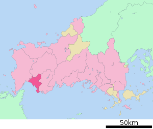
San’yō-Onoda (jap. 山陽小野田市, -shi) ist eine Stadt in der Präfektur Yamaguchi in Japan.
Inhaltsverzeichnis
Geographie
San’yō-Onoda liegt östlich von Shimonoseki und westlich von Ube an der Seto-Inlandsee.
Geschichte
Die Stadt San’yō-Onoda wurde am 22. März 2005 aus der Stadt Onoda (小野田市, -shi) und der Gemeinde San’yō (山陽町, -chō) des Landkreises Asa gegründet.
Verkehr
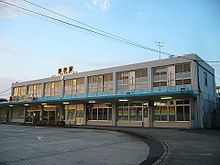 Bahnhof Asa
- Zug:
- JR San’yō-Shinkansen
- JR San’yō-Hauptlinie
- JR Onoda-Linie
- JR Mine-Linie
- Straße:
- San’yō-Autobahn
- Chūgoku-Autobahn
- Nationalstraße 2
- Nationalstraße 9
- Nationalstraße 190, 316
Angrenzende Städte und Gemeinden
Weblinks

- Zug:


Wikimedia Foundation.