- Scott County (Kentucky)
-
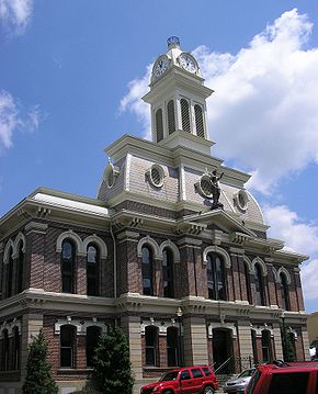 Scott County Courthouse in Georgetown
Verwaltung US-Bundesstaat: Kentucky Verwaltungssitz: Georgetown Adresse des
Verwaltungssitzes:County Courthouse
P.O. Box 973
Georgetown, KY 40324-0973Gründung: 22. Juni 1792 Gebildet aus: Woodford County Vorwahl: 001 502 Demographie Einwohner: 33.061 (2000) Bevölkerungsdichte: 44,8 Einwohner/km² Geographie Fläche gesamt: 739 km² Wasserfläche: 1 km² Karte 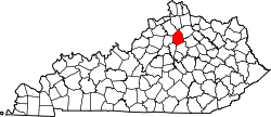
Website: www.scottky.com Scott County[1] ist ein County im Bundesstaat Kentucky der Vereinigten Staaten von Amerika. Bei der Volkszählung im Jahr 2000 hatte das County 33.061 Einwohner und eine Bevölkerungsdichte von 45 Einwohner pro Quadratkilometer. Der Verwaltungssitz (County Seat) ist Georgetown, benannt nach Präsident George Washington.
Inhaltsverzeichnis
Geografie
Das County liegt im mittleren Norden von Kentucky und hat eine Fläche von 739 Quadratkilometern, wovon 1 Quadratkilometer Wasserfläche sind. Es grenzt im Uhrzeigersinn an folgende Countys: Grant County, Harrison County, Bourbon County, Fayette County, Woodford County, Franklin County und Owen County.
Geschichte
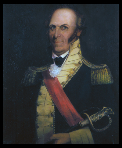
 Charles Scott
Scott County wurde bereits vor 1774 erkundet und am 22. Juni 1792 aus Teilen des Woodford County gebildet.
Einer der ersten Siedler war John McClelland aus Pennsylvania. 1783 gründete Robert Johnson die erste permanente Ansiedlung bei Johnson's Station.
Benannt wurde das County nach Charles Scott, einem General, Helden im Amerikanischen Unabhängigkeitskrieg und späteren Gouverneur. Scott führte 1791 die Kentucky-Miliz in die Schlacht von Wabash und 1794 führte er sie in der Schlacht von Fallen Timbers zum Sieg. Er galt als ein Mann mit festen Grundsätzen. Teilweise wurde er auch als exzentrisch und unhöflich beschrieben. Scott hatte insgesamt sieben Kinder. Er starb im Oktober 1813.
Demografische Daten
Historische Einwohnerzahlen Census Einwohner ± in % 1800 8007 — 1810 12.419 60 % 1820 14.219 10 % 1830 14.677 3 % 1840 13.668 -7 % 1850 14.946 9 % 1860 14.417 -4 % 1870 11.607 -20 % 1880 14.965 30 % 1890 16.546 10 % 1900 18.076 9 % 1910 16.956 -6 % 1920 15.318 -10 % 1930 14.400 -6 % 1940 14.314 -0,6 % 1950 15.141 6 % 1960 15.376 2 % 1970 17.948 20 % 1980 21.813 20 % 1990 23.867 9 % 2000 33.061 40 % Vor 1900[2] 1900–1990[3]
Nach der Volkszählung im Jahr 2000 lebten im Scott County 33.061 Menschen in 12.110 Haushalten und 8.985 Familien. Die Bevölkerungsdichte betrug 45 Einwohner pro Quadratkilometer. Ethnisch betrachtet setzte sich die Bevölkerung zusammen aus 91,94 Prozent Weißen, 5,35 Prozent Afroamerikanern, 0,26 Prozent amerikanischen Ureinwohnern, 0,50 Prozent Asiaten, 0,01 Prozent Bewohnern aus dem pazifischen Inselraum und 0,82 Prozent aus anderen ethnischen Gruppen; 1,13 Prozent stammten von zwei oder mehr Ethnien ab. 1,61 Prozent der Bevölkerung waren spanischer oder lateinamerikanischer Abstammung.
Von den 12.110 Haushalten hatten 38,5 Prozent Kinder und Jugendliche unter 18 Jahre, die bei ihnen lebten. 58,8 Prozent waren verheiratete, zusammenlebende Paare, 11,5 Prozent waren allein erziehende Mütter, 25,8 Prozent waren keine Familien, 21,0 Prozent waren Singlehaushalte und in 7,0 Prozent lebten Menschen im Alter von 65 Jahren oder darüber. Die Durchschnittshaushaltsgröße betrug 2,61 und die durchschnittliche Familiengröße lag bei 3,01 Personen.
Auf das gesamte County bezogen setzte sich die Bevölkerung zusammen aus 26,3 Prozent Einwohnern unter 18 Jahren, 11,8 Prozent zwischen 18 und 24 Jahren, 32,6 Prozent zwischen 25 und 44 Jahren, 20,4 Prozent zwischen 45 und 64 Jahren und 8,9 Prozent waren 65 Jahre alt oder darüber. Das Durchschnittsalter betrug 32 Jahre. Auf 100 weibliche Personen kamen 95,8 männliche Personen. Auf 100 Frauen im Alter von 18 Jahren alt oder darüber kamen statistisch 90,7 Männer.
Das jährliche Durchschnittseinkommen eines Haushalts betrug 47.081 USD, das Durchschnittseinkommen der Familien betrug 54.117 USD. Männer hatten ein Durchschnittseinkommen von 40.604 USD, Frauen 25.767 USD. Das Prokopfeinkommen betrug 21.490 USD. 7,3 Prozent der Familien und 8,8 Prozent der Bevölkerung lebten unterhalb der Armutsgrenze. Davon waren 11,0 Prozent Kinder oder Jugendliche unter 18 Jahre und 12,1 Prozent waren Menschen über 65 Jahre. [4]
Einzelnachweise
- ↑ GNIS-ID: 516951. Abgerufen am 22. Februar 2011 (englisch).
- ↑ U.S. Census Bureau _ Census of Population and Housing. Abgerufen am 18. Februar 2011
- ↑ Auszug aus Census.gov. Abgerufen am 18. Februar 2011
- ↑ Scott County, Kentucky, Datenblatt mit den Ergebnissen der Volkszählung im Jahre 2000 bei factfinder.census.gov.
Weblinks
-
 Commons: Scott County, Kentucky – Sammlung von Bildern, Videos und Audiodateien

Liste der Countys in Kentucky
Adair | Allen | Anderson | Ballard | Barren | Bath | Bell | Boone | Bourbon | Boyd | Boyle | Bracken | Breathitt | Breckinridge | Bullitt | Butler | Caldwell | Calloway | Campbell | Carlisle | Carroll | Carter | Casey | Christian | Clark | Clay | Clinton | Crittenden | Cumberland | Daviess | Edmonson | Elliott | Estill | Fayette | Fleming | Floyd | Franklin | Fulton | Gallatin | Garrard | Grant | Graves | Grayson | Green | Greenup | Hancock | Hardin | Harlan | Harrison | Hart | Henderson | Henry | Hickman | Hopkins | Jackson | Jefferson | Jessamine | Johnson | Kenton | Knott | Knox | LaRue | Laurel | Lawrence | Lee | Leslie | Letcher | Lewis | Lincoln | Livingston | Logan | Lyon | Madison | Magoffin | Marion | Marshall | Martin | Mason | McCracken | McCreary | McLean | Meade | Menifee | Mercer | Metcalfe | Monroe | Montgomery | Morgan | Muhlenberg | Nelson | Nicholas | Ohio | Oldham | Owen | Owsley | Pendleton | Perry | Pike | Powell | Pulaski | Robertson | Rockcastle | Rowan | Russell | Scott | Shelby | Simpson | Spencer | Taylor | Todd | Trigg | Trimble | Union | Warren | Washington | Wayne | Webster | Whitley | Wolfe | Woodford
Wikimedia Foundation.
Schlagen Sie auch in anderen Wörterbüchern nach:
Scott County Courthouse (Scott County, Kentucky) — Infobox nrhp |name =Scott County Courthouse nrhp type = nrhp caption = Scott County Courthouse location= Georgetown, Kentucky lat degrees = 38 lat minutes = 12 lat seconds = 36 lat direction = N long degrees = 84 long minutes = 33 long seconds =… … Wikipedia
Scott County, Kentucky — Infobox U.S. County county = Scott County state = Kentucky founded year = 1792 founded date = seat wl = Georgetown largest city wl = area total sq mi = 285 area total km2 = 739 area land sq mi = 285 area land km2 = 737 area water sq mi = 1 area… … Wikipedia
Scott County Jail Complex (Scott County, Kentucky) — Infobox nrhp name = Scott County Jail Complex nrhp type =nrhp caption = Scott County Jail Complex location= Georgetown, Kentucky lat degrees = 38 lat minutes = 12 lat seconds = 38.34 lat direction = N long degrees = 84 long minutes = 33 long… … Wikipedia
National Register of Historic Places listings in Scott County, Kentucky — Location of Scott County in Kentucky This is a list of the National Register of Historic Places listings in Scott County, Kentucky. It is intended to be a complete list of the properties and districts on the National Register of Historic Places… … Wikipedia
Allenhurst (Scott County, Kentucky) — Infobox nrhp |name =Allenhurst nrhp type = nrhp caption = nearest city= Georgetown, Kentucky lat degrees = 38 lat minutes = 11 lat seconds = 31 lat direction = N long degrees = 84 long minutes = 36 long seconds = 55 long direction = W locmapin =… … Wikipedia
Audubon (Scott County, Kentucky) — Infobox nrhp | name =Audubon nrhp type = nrhp caption = nearest city= Georgetown, Kentucky lat degrees = 38 lat minutes = 9 lat seconds = 18 lat direction = N long degrees = 84 long minutes = 37 long seconds = 22 long direction = W locmapin =… … Wikipedia
Georgetown College Historic Buildings (Scott County, Kentucky) — Infobox nrhp | name =Georgetown College Historic Buildings nrhp type = hd caption = location= Georgetown, Kentucky lat degrees = 38 lat minutes = 12 lat seconds = 25 lat direction = N long degrees = 84 long minutes = 33 long seconds = 17 long… … Wikipedia
Hawkins House (Scott County, Kentucky) — Infobox nrhp | name =Hawkins House nrhp type = caption = location= Georgetown, Kentucky lat degrees = 38 lat minutes = 12 lat seconds = 23 lat direction = N long degrees = 84 long minutes = 33 long seconds = 22 long direction = W locmapin =… … Wikipedia
First African Baptist Church and Parsonage (Scott County, Kentucky) — Infobox nrhp | name =First African Baptist Church and Parsonage nrhp type = nrhp caption = location= Georgetown, Kentucky lat degrees = 38 lat minutes = 12 lat seconds = 45 lat direction = N long degrees = 84 long minutes = 33 long seconds = 40… … Wikipedia
Scott County — is the name of eleven counties in the United States of America: Scott County, Arkansas Scott County, Illinois Scott County, Indiana Scott County, Iowa Scott County, Kansas Scott County, Kentucky Scott County, Minnesota Scott County, Mississippi… … Wikipedia
Scott County (Kentucky)


18+
© Academic, 2000-2025
- Kontaktieren Sie uns: Unterstützung, Werbung
Wörterbücher Export, schritte mit PHP, Joomla, Drupal, WordPress, MODx.