- Second Mesa
-
Second Mesa 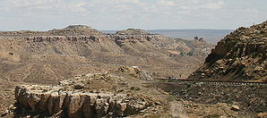
Die zu Second Mesa gehörende Siedlung Mishongnovi auf dem Ausläufer eines Tafelbergs, gesehen von der Arizona State Route 264.Lage im County und in Arizona 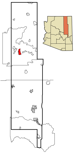
Basisdaten Staat: Vereinigte Staaten Bundesstaat: Arizona County: Koordinaten: 35° 49′ N, 110° 30′ W35.8175-110.504166666671737Koordinaten: 35° 49′ N, 110° 30′ W Zeitzone: Mountain Standard Time (UTC−7) Einwohner: 814 (Stand: 2000) Bevölkerungsdichte: 11,9 Einwohner je km² Fläche: 68,6 km² (ca. 26 mi²)
davon 68,5 km² (ca. 26 mi²) LandHöhe: 1737 m Postleitzahl: 86043 Vorwahl: +1 928 FIPS: 04-65280 GNIS-ID: 0042897 Second Mesa ist ein Census-designated place im Norden des US-Bundesstaates Arizonas im Navajo County. Der Ort hat 814 Einwohner auf einer Fläche von 68,5 km². Second Mesa liegt ganz in der Navajo-Nation-Reservation. Die Bevölkerung ist verteilt auf drei Dörfer der Hopi-Indianer. Sie befinden sich auf einem Tafelberg (Mesa) und heißen Musungnuvi (auch Mishongnovi), Supawlavi (auch Sipaulovi) und Songoopavi (auch Shungopavi). Weitere Ortsteile sind Old Shongopavi und Shipolovi.
In Second Mesa beginnt die Arizona State Route 87 an der Arizona State Route 264.
Bildung
Second Mesa liegt im Cedar Unified School District. In Second Mesa befindet sich die White Cone High School.
 Orte im Navajo County
Holbrook | Pinetop-Lakeside | Show Low | Snowflake | Taylor | Winslow | Chilchinbito | Cibecue | Dilkon | East Fork | First Mesa | Greasewood | Heber-Overgaard | Hotevilla-Bacavi | Jeddito | Kayenta | Keams Canyon | Kykotsmovi Village | McNary (auch im Apache County) | Oljato-Monument Valley | Pinon | Second Mesa | Shongopovi | Shonto | Whiteriver | Winslow West
Wikimedia Foundation.
Schlagen Sie auch in anderen Wörterbüchern nach:
Second Mesa — Lugar designado por el censo de los Estados Unidos Mishongnovi … Wikipedia Español
Second Mesa — Second Mesa, AZ U.S. Census Designated Place in Arizona Population (2000): 814 Housing Units (2000): 255 Land area (2000): 26.445258 sq. miles (68.492902 sq. km) Water area (2000): 0.000000 sq. miles (0.000000 sq. km) Total area (2000): 26.445258 … StarDict's U.S. Gazetteer Places
Second Mesa, AZ — U.S. Census Designated Place in Arizona Population (2000): 814 Housing Units (2000): 255 Land area (2000): 26.445258 sq. miles (68.492902 sq. km) Water area (2000): 0.000000 sq. miles (0.000000 sq. km) Total area (2000): 26.445258 sq. miles… … StarDict's U.S. Gazetteer Places
Second Mesa, Arizona — Infobox Settlement official name = Second Mesa, Arizona settlement type = CDP imagesize = image caption = image imagesize = image caption = image mapsize = 250px map caption = Location in Navajo County and the state of Arizona mapsize1 = map… … Wikipedia
Mesa (Arizona) — Mesa Siegel Flagge … Deutsch Wikipedia
Mesa, Arizona — Mesa City Mesa Bank and Mesa Arts Center building in downtown Mesa … Wikipedia
Mesa High School (Mesa, Arizona) — Mesa High School Location 1630 East Southern Avenue Mesa, Arizona, USA … Wikipedia
Mesa Oil Field — The Mesa Oil Field in Santa Barbara County, California. Other oil fields are shown in light gray. Country United States Region Santa Barbara south coast … Wikipedia
Mesa Verde National Park — Mesa Verde redirects here. For other uses, see Mesa Verde (disambiguation). Mesa Verde National Park IUCN Category II (National Park) … Wikipedia
Mesa Air Group — Type Private Industry Aviation Founded 1982 Headquarters … Wikipedia
Second Mesa


18+
© Academic, 2000-2026
- Kontaktieren Sie uns: Unterstützung, Werbung
Wörterbücher Export, schritte mit PHP, Joomla, Drupal, WordPress, MODx.