- Sharpsburg Historic District
-
Sharpsburg 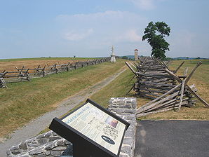
Antietam National Battlefield bei SharpsburgLage von Sharpsburg, Maryland 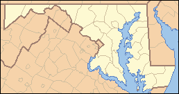

Sharpsburg Basisdaten Gründung: 1763 Staat: Vereinigte Staaten Bundesstaat: Maryland County: Washington County (Maryland) Koordinaten: 39° 27′ N, 77° 45′ W39.457777777778-77.749444444444128Koordinaten: 39° 27′ N, 77° 45′ W Zeitzone: EST Einwohner: 691 (Stand: 2000) Bevölkerungsdichte: 1.151,7 Einwohner je km² Fläche: 0,6 km²
davon 0,6 km² LandHöhe: 128 m Postleitzahl: 21782 Vorwahl: +1 301 FIPS: 24-71600 GNIS-ID: 0587310 Webpräsenz: www.sharpsburg-md.com Sharpsburg ist ein Ort im Washington County im Bundesstaat Maryland in den Vereinigten Staaten von Amerika. Der Ort liegt etwa 20 Kilometer südlich von Hagerstown. In Sharpsburg wohnen 691 Menschen.[1]. Während des Sezessionskrieges fand in Sharpsburg in der Umgebung des Antietam Creek die Schlacht von Antietam statt, an die heute das Antietam National Battlefield erinnert.
Inhaltsverzeichnis
Geschichte
Ein Siedler namens Joseph Chapline zog um 1740 in die Gegend, nach Beendigung des Franzosen- und Indianerkrieges gründete er die Stadt im Jahre 1763. Er benannte den Ort zu Ehren seines Freundes und des proprietären Gouverneurs der Provinz Maryland, Horatio Sharpe. Auf der Oststeite des Potomac River gelegen, hatte der Ort Zugang zu Wasserkraft und wurde im frühen 19. Jahrhundert ein bevorzugter Standort für die Industrie. Dies verstärkte sich, als der Chesapeake and Ohio Canal im Jahre 1836 bis nach Sharpsburg verlängert wurde.
Der konföderierte General Robert E. Lee marschierte im Spätsommer 1862 in Maryland ein und wurde vom General der Union George B. McClellan verfolgt. Ihre Armeen trafen am 17. September 1862 in der Schlacht bei Antietam aufeinander, die in den Südstaaten auch als Schlacht von Sharpsburg bezeichnet wird. Die Schlacht gilt mit 23.000 Getöteten als der blutigste Tag des Sezessionskrieges und der us-amerikanischen Militärgeschichte. Der militärisch ergebnislose aber strategisch wichtige Sieg der Union erlaubte es Abraham Lincoln die Emanzipations-Proklamation abzugeben. Dieser Sieg war ein Wendepunkt des Krieges, weil er die Konföderierten in ihrem Fortschritt bremste und einem Sieg auf dem Boden der Union verhinderte.
Der Ort selbst wurde dem National Register of Historic Places (Nationales Register historischer Stätten) als Sharpsburg Historic District im Jahre 2008 hinzugefügt.[2]
Geographie
Nach Angaben des United States Census Bureau umfasst der Ort eine Fläche von 0,6 Quadratkilometern.
Demographie
Nach der Volkszählung im Jahr 2000 lebten hier 691 Menschen in 286 Haushalten und 193 Familien. Die Bevölkerungsdichte beträgt 1212,7 Einwohner pro km². Ethnisch betrachtet setzt sich die Bevölkerung zusammen aus 97,83% weißer Bevölkerung, 0,43% Afroamerikanern, 0,58% Asiaten, 1,16% stammen von zwei oder mehr Ethnien ab. 0,29% der Bevölkerung sind spanischer oder lateinamerikanischer Abstammung.
Von den 286 Haushalten hatten 26,6% Kinder unter 18 Jahren, die bei ihnen lebten, 54,2% davon waren verheiratete, zusammenlebende Paare, 9,4% waren allein erziehende Mütter und 32,5% waren keine Familien. 26,2% bestanden aus Singlehaushalten und in 8% lebten Menschen mit 65 Jahren oder älter. Die Durchschnittshaushaltsgröße betrug 2,42 und die durchschnittliche Familiengröße war 2,9 Personen.
21,7% der Bevölkerung waren unter 18 Jahre alt. 8,7% zwischen 18 bis 24 Jahre, 29,1% zwischen 25 bis 44 Jahre, 27,6% zwischen 45 bis 64, und 12,9% waren 65 Jahre alt oder Älter. Das Durchschnittsalter betrug 38 Jahre. Auf 100 weibliche Personen kamen 103,2 männliche Personen. Auf 100 Frauen im Alter von 18 Jahren oder darüber kamen 101,9 Männer.
Das jährliche Durchschnittseinkommen eines Haushalts betrug $41.786 und das jährliche Durchschnittseinkommen einer Familie betrug $52.875. Männer hatten ein durchschnittliches Einkommen von $37.500 gegenüber den Frauen mit $22.000. Das Prokopfeinkommen betrug $20.917. 1,1% der Bevölkerung und 3,1% der Familien lebten unterhalb der Armutsgrenze. Darunter sind keine Kinder und Jugendliche unter 18 Jahre, aber 5,6% sind 65 Jahre oder älter.
Einzelnachweise
- ↑ US Census 2000
- ↑ WEEKLY LIST OF ACTIONS TAKEN ON PROPERTIES: 12/22/08 THROUGH 12/24/08. National Register of Historic Places. National Park Service (2. März 2009).
Weblinks

Wikimedia Foundation.