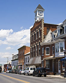
- Washington County (Maryland)
-
Verwaltung US-Bundesstaat: Maryland Verwaltungssitz: Hagerstown Adresse des
Verwaltungssitzes:Washington County Government
100 W. Washington St.
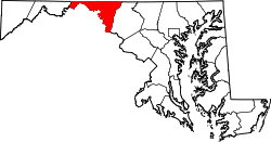
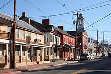
Hagerstown, MD 21740Gründung: 1776 Gebildet aus: Prince George's County Vorwahl: 001 301 Demographie Einwohner: 147.430 (2010) Bevölkerungsdichte: 124,2 Einwohner/km² Geographie Fläche gesamt: 1.211 km² Wasserfläche: 24 km² Karte Website: www.washco-md.net Das Washington County[2] ist ein County im US-amerikanischen Bundesstaat Maryland. Bei der Volkszählung im Jahr 2010 hatte das County 147.430 Einwohner und eine Bevölkerungsdichte von 124,2 Einwohnern pro Quadratkilometer. Der Verwaltungssitz (County Seat) ist Hagerstown.
Inhaltsverzeichnis
Geografie
Das County wird im Norden durch die Mason-Dixon-Linie von Pennsylvania getrennt. Im Süden bildet der Potomac River die Grenze zu West Virginia und Virginia. Das Washington County hat eine Fläche von 1.211 Quadratkilometern; davon sind 24 Quadratkilometer (2,01 Prozent) Wasserflächen. Es grenzt an folgende Couny:
Schutzgebiete
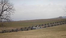
- Antietam National Battlefield
- Appalachian National Scenic Trail
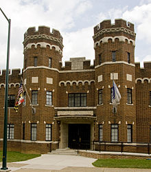
- Chesapeake and Ohio Canal National Historical Park
- Fort Frederick State Park
- Fort Tonoloway State Park
- Gathland State Park
- Greenbrier State Park
- Harpers Ferry National Historical Park
- South Mountain State Park
- Washington Monument State Park
Geschichte
Das Washington County wurde 1776 aus dem Prince George's County gebildet. Benannt wurde es nach George Washington (1732-1799), dem ersten Präsidenten der USA.
1789 wurde das Allegany County ausgegliedert.
1862 ereignete sich mit der Schlacht am Antietam bei Sharpsburg eine der verlustreichsten Schlachten des Amerikanischen Bürgerkrieges.
Demografische Daten
Historische Einwohnerzahlen Census Einwohner ± in % 1790 15.822 — 1800 18.650 20 % 1810 18.730 0,4 % 1820 23.075 20 % 1830 25.268 10 % 1840 28.850 10 % 1850 30.848 7 % 1860 31.417 2 % 1870 34.712 10 % 1880 38.561 10 % 1890 39.782 3 % 1900 45.133 10 % 1910 49.617 10 % 1920 59.694 20 % 1930 65.882 10 % 1940 68.838 4 % 1950 78.886 10 % 1960 91.219 20 % 1970 103.829 10 % 1980 113.086 9 % 1990 121.393 7 % 2000 131.923 9 % 2010 147.430 10 % vor 1900[5] 1900–1990[6] 2000[7] 2010[8] Nach der Volkszählung im Jahr 2010 lebten im Washington County 147.430 Menschen in 55,524 Haushalten. Die Bevölkerungsdichte betrug 124,2 Einwohner pro Quadratkilometer.
Ethnisch betrachtet setzte sich die Bevölkerung zusammen aus 85,1 Prozent Weißen, 9,6 Prozent Afroamerikanern, 0,2 Prozent amerikanischen Ureinwohnern, 1,4 Prozent Asiaten sowie aus anderen ethnischen Gruppen; 2,6 Prozent stammten von zwei oder mehr Ethnien ab. Unabhängig von der ethnischen Zugehörigkeit waren 3,5 Prozent der Bevölkerung spanischer oder lateinamerikanischer Abstammung.
In den 55,524 Haushalten lebten statistisch je 2,47 Personen.
22,9 Prozent der Bevölkerung waren unter 18 Jahre alt, 62,8 Prozent waren zwischen 18 und 64 und 14,3 Prozent waren 65 Jahre oder älter. 49,2 Prozent der Bevölkerung war weiblich.
Das jährliche Durchschnittseinkommen eines Haushalts lag bei 48.883 USD. Das Pro - Kopf - Einkommen betrug 26.802 USD. 12,4 Prozent der Einwohner lebten unterhalb der Armutsgrenze.[10]
Städte und Gemeinden
- Boonsboro
- Clear Spring
- Funkstown
- Hancock
- Keedysville
- Sharpsburg
- Smithsburg
- Williamsport
Census-designated places (CDP)
- Cavetown
- Chewsville
- Fort Ritchie
- Halfway
- Leitersburg
- Maugansville
- Mount Aetna
- Mount Lena
- Robinwood
- Rohrersville
- Saint James
- San Mar
- Bearbeiten] Einzelnachweise
- ↑ Auszug aus dem National Register of Historic Places - Nr. 85002673 Abgerufen am 15. September 2011
- ↑ GNIS-ID: 1714220. Abgerufen am 22. Februar 2011 (englisch).
- ↑ Auszug aus dem National Register of Historic Places - Nr. 66000038 Abgerufen am 15. September 2011
- ↑ Auszug aus dem National Register of Historic Places - Nr. 05001431 Abgerufen am 15. September 2011
- ↑ University of Virginia Library - Historical Census Browser Abgerufen am 14. September 2011
- ↑ United States Census.gov Abgerufen am 14. September 2011
- ↑ U.S. Census Buero - United States Census 2000 für das Washington County Abgerufen am 14. September 2011
- ↑ United States Census 2010 Abgerufen am 14. September 2011
- ↑ Auszug aus dem National Register of Historic Places - Nr. 01001184 Abgerufen am 15. September 2011
- ↑ U.S. Census Buero, State & County QuickFacts - Washington County Abgerufen am 14. September 2011
Weblinks
-
 Commons: Washington County, Maryland – Sammlung von Bildern, Videos und Audiodateien
 - Offizielle Webseite
- U.S. Census Buero, State & County QuickFacts - Washington County
- Maryland State Archives - Washington County
- Yahoo Bildersuche - Washington County
- www.city-data.com - Washington County
Liste der Countys in Maryland
Allegany | Anne Arundel | Baltimore City | Baltimore | Calvert | Caroline | Carroll | Cecil | Charles | Dorchester | Frederick | Garrett | Harford | Howard | Kent | Montgomery | Prince George’s | Queen Anne’s | Saint Mary's | Somerset | Talbot | Washington | Wicomico | Worcester
Wikimedia Foundation.
Schlagen Sie auch in anderen Wörterbüchern nach:
Washington County, Maryland — Infobox U.S. County county = Washington County state = Maryland founded year = 1776 seat wl = Hagerstown largest city wl = Hagerstown area total sq mi = 468 area land sq mi = 458 area water sq mi = 9 area percentage = 2.01% census yr = 2000 pop … Wikipedia
National Register of Historic Places listings in Washington County, Maryland — Location of Washington County in Maryland This is a list of the National Register of Historic Places listings in Washington County, Maryland. This is intended to be a complete list of the properties and districts on the National Register of… … Wikipedia
Washington County Sheriff's Office — could refer to several sheriffs departments in the United States including:*Washington County, Alabama Sheriff s Office *Washington County, Arkansas Sheriff s Department *Washington County, Colorado Sheriff s Office *Washington County, Florida… … Wikipedia
Washington County — heißen: Washington County (Alabama) Washington County (Arkansas) Washington County (Colorado) Washington County (Florida) Washington County (Georgia) Washington County (Idaho) Washington County (Illinois) Washington County (Indiana) Washington… … Deutsch Wikipedia
Washington County Public Schools — is a public school system run for the residents of Washington County, Maryland, United States.High schools*Antietam Academy, Hagerstown *Barbara Ingram School for the Arts, Hagerstown (magnet school) *Boonsboro High School, Boonsboro *Clear… … Wikipedia
Washington County Technical High School — is a public school offering technology related and general classes for students in 11th and 12th grades. The school building is located on a tract of land with several schools including South Hagerstown High School. This area lies near the… … Wikipedia
Washington County — See also: List of counties in Washington for counties in the state of Washington. Washington County is the name of 30 counties and one parish in the United States of America: Contents 1 Extant counties 2 Extinct counties 3 Other … Wikipedia
Washington Grove, Maryland — Infobox Settlement official name = Washington Grove, Maryland settlement type = Town nickname = motto = imagesize = image caption = image imagesize = image caption = image mapsize = 250x200px map caption = Location of Washington Grove, Maryland… … Wikipedia
Washington County Courthouse — bezeichnet mehrere gleichnamige, im NRHP gelistete, Objekte: Washington County Courthouse (Alabama), ID Nr. 97000655 Washington County Courthouse (Arkansas), ID Nr. 72000212 Washington County Courthouse (Georgia), ID Nr. 80001260 Washington… … Deutsch Wikipedia
Washington County Courthouse — may refer to one of these United States courthouses:* Washington County Courthouse (Alabama) * Washington County Courthouse (Arkansas) * Washington County Courthouse (Florida) * Washington County Courthouse (Georgia) * Washington County… … Wikipedia

