- Shire of Baw Baw
-
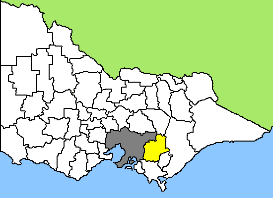
Baw Baw Shire 
Lage des Baw Baw Shire in Victoria Basisdaten Bundesstaat: Victoria Hauptort: Warragul Fläche: 3.855 km² Einwohner: 39.765 (Juni 2006) Wards: 9 Baw Baw Shire ist ein lokales Verwaltungsgebiet (LGA) im australischen Bundesstaat Victoria. Das Gebiet ist 3.855 km² groß und hat etwa 40.000 Einwohner.
Baw Baw liegt in der Osthälfte Victorias und grenzt im Westen an die Hauptstadt Melbourne. Das Gebiet schließt folgende Ortschaften ein: Longwarry, Drouin, Warragul, Darnum, Yarragon, Trafalgar, Neerim South, Noojee, Thorpdale, Rawson und Erica. Der Sitz des City Councils befindet sich in Warragul im Südwesten der LGA mit etwa 11.500 Einwohnern (Stand 2006[1]).
Benannt ist das Shire nach dem 1564 m hohen Mount Baw Baw, wo auch das kleinste der Skigebiete Victorias liegt. Die Ausläufer der Great Dividing Range prägen den Norden der Region, während der hügelige und dichter besiedelte Süden dem landwirtschaftlich geprägten Gippsland zuzurechnen ist. Eine der Attraktionen des Shires ist die historische Goldgräberstadt Walhalla mit einer der ertragreichsten Goldminen der Goldgräberzeit, der Long Tunnel Extended Gold Mine.
Verwaltung
Der Baw Baw Shire Council hat neun Mitglieder, die von den Bewohnern der neun Wards gewählt werden. Diese neun Bezirke sind Bloomfield, Drouin, Lardner, Longwarry, Mount Worth, Tarago, Thomson, Warragul East und Warragul West. Aus dem Kreis der Councillor rekrutiert sich auch der Mayor (Bürgermeister) des Councils.
Quellen
- ↑ Australian Bureau of Statistics Veröffentlichung 25. Oktober 2007
Weblinks
- Offizielle Seite (englisch)
Ländliche Gebiete: Alpine | Ararat | Ballarat | Bass Coast | Baw Baw | Benalla | Buloke | Campaspe | Central Goldfields | Colac Otway | Corangamite | East Gippsland | Gannawarra | Glenelg | Golden Plains | Greater Bendigo | Greater Geelong | Greater Shepparton | Hepburn | Hindmarsh | Horsham | Indigo | Latrobe | Loddon | Macedon Ranges | Mansfield | Mildura | Mitchell | Moira | Moorabool | Mount Alexander | Moyne | Murrindindi | Northern Grampians | Pyrenees | Queenscliffe | South Gippsland | Southern Grampians | Strathbogie | Surf Coast | Swan Hill | Towong | Wangaratta | Warrnambool | Wellington | West Wimmera | Wodonga | Yarriambiack
Greater Melbourne: Banyule | Bayside | Boroondara | Brimbank | Cardinia | Casey | Darebin | Frankston | Glen Eira | Greater Dandenong | Hobsons Bay | Hume | Kingston | Knox | Manningham | Maroondah | Maribyrnong | Melbourne | Melton | Monash | Moonee Valley | Moreland | Mornington Peninsula | Nillumbik | Port Phillip | Stonnington | Whitehorse | Whittlesea | Wyndham | Yarra | Yarra Ranges
Wikimedia Foundation.