- St. Clair County (Illinois)
-
 Das St. Clair County Courthouse in Belleville
Verwaltung US-Bundesstaat: Illinois Verwaltungssitz: Belleville Adresse des
Verwaltungssitzes:St. Clair County Office
10 Public Square
Belleville, IL 62220Gründung: 27. April 1790 Gebildet aus: Original-County Vorwahl: 001 618 Demographie Einwohner: 270.056 (Schätzung 2010) Bevölkerungsdichte: 157 Einwohner/km² Geographie Fläche gesamt: 1.746 km² Wasserfläche: 26 km² Karte 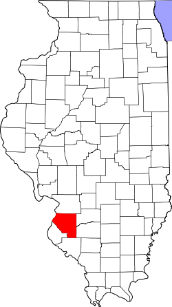
Website: www.co.st-clair.il.us Das St. Clair County[1] ist ein County im US-amerikanischen Bundesstaat Illinois. Bei der Volkszählung im Jahr 2010 hatte das County 270.056 Einwohner und eine Bevölkerungsdichte von 157 Einwohnern pro Quadratkilometer. Der Verwaltungssitz (County Seat) ist Belleville.[2]
Das St. Clair County liegt im Metro-East genannten östlichen Teil der Metropolregion Greater St. Louis um die Stadt St. Louis im benachbarten Missouri.
Inhaltsverzeichnis
Geografie
Das County liegt im Südwesten von Illinois, mit der westlichen Grenze am Mississippi River gegenüber von St. Louis in Missouri und hat eine Fläche von 1.746 km², wovon 26 km² Wasserfläche sind. Es grenzt an folgende Countys:
Madison County Clinton County St. Louis (Missouri)1
St. Louis County (Missouri)
Washington County Monroe County Randolph County 1 - hierbei handelt es sich um kein County, sondern eine unabhängige Stadt (independent city)
Geschichte
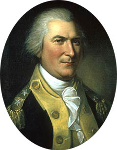
 A. St. Clair
Das St. Clair County wurde am 27. April 1790 als erstes County im damaligen Illinois - Territorium gebildet und umfasste etwa ein Viertel des späteren Bundesstaates Illinois. Benannt wurde es nach Arthur St. Clair (1734-1818), Präsident des Kontinentalkongresses (1787-1787), General der Kontinentalarmee im Unabhängigkeitskrieg (1775-1783) und Gouverneur des Nordwestterritoriums (1788-1802).
Demografische Daten
Historische Einwohnerzahlen Census Einwohner ± in % 1800 1255 — 1810 5007 300 % 1820 5248 5 % 1830 7078 30 % 1840 13.631 90 % 1850 20.180 50 % 1860 37.694 90 % 1870 51.068 40 % 1880 61.806 20 % 1890 66.571 8 % 1900 86.685 30 % 1910 119.870 40 % 1920 136.520 10 % 1930 157.775 20 % 1940 166.899 6 % 1950 205.995 20 % 1960 262.509 30 % 1970 285.176 9 % 1980 267.531 -6 % 1990 262.852 -2 % 2000 256.082 -3 % 2010 270.056 5 % Vor 1900[3] 1900–1990[4] 2010[5] Nach der Volkszählung im Jahr 2010 lebten im St. Clair County 270.056 Menschen in 102.488 Haushalten. Die Bevölkerungsdichte betrug 157 Einwohner pro Quadratkilometer.
Ethnisch betrachtet setzte sich die Bevölkerung zusammen aus 64,6 Prozent Weißen, 30,5 Prozent Afroamerikanern, 0,2 Prozent amerikanischen Ureinwohnern, 1,2 Prozent Asiaten sowie aus anderen ethnischen Gruppen; 2,2 Prozent stammten von zwei oder mehr Ethnien ab. Unabhängig von der ethnischen Zugehörigkeit waren 3,3 Prozent der Bevölkerung spanischer oder lateinamerikanischer Abstammung.
In den 102.488 Haushalten lebten statistisch je 2,51 Personen.
25,3 Prozent der Bevölkerung waren unter 18 Jahre alt, 62,1 Prozent waren zwischen 18 und 64 und 12,6 Prozent waren 65 Jahre oder älter. 52,2 Prozent der Bevölkerung war weiblich.
Das jährliche Durchschnittseinkommen eines Haushalts lag bei 46.368 USD. Das Pro - Kopf - Einkommen betrug 24.316 USD. 17,1 Prozent der Einwohner lebten unterhalb der Armutsgrenze.[7]
Städte und Gemeinden
- Belleville
- Centreville
- Collinsville1
- Columbia2
- East St. Louis
- Fairview Heights
- Lebanon
- Madison1
- Mascoutah
- O'Fallon
- Alorton
- Brooklyn
- Cahokia
- Caseyville
- Dupo
- East Carondelet
- Fairmont City
- Fayetteville
- Freeburg
- Hecker2
- Lenzburg
- Marissa
- St. Libory
- Summerfield
- Swansea
- Washington Park
1 - überwiegend im Madison County
2 - teilweise im Monroe County
3 - teilweise im Madison County
4 - teilweise im Clinton CountyEinzelnachweise
- ↑ GNIS-ID: 1784987. Abgerufen am 22. Februar 2011 (englisch).
- ↑ National Association of Counties Abgerufen am 21. September 2011
- ↑ U.S. Census Bureau - Census of Population and Housing Abgerufen am 15. März 2011
- ↑ Auszug aus Census.gov Abgerufen am 15. Februar 2011
- ↑ United States Census 2010 Abgerufen am 21. September 2011
- ↑ Auszug aus dem National Register of Historic Places. Abgerufen am 13. März 2011
- ↑ U.S. Census Buero, State & County QuickFacts - St. Clair County Abgerufen am 21. September 2011
Weblinks
-
 Commons: St. Clair County, Illinois – Sammlung von Bildern, Videos und Audiodateien
 - Offizielle Webseite
- U.S. Census Buero, State & County QuickFacts - St. Clair County
- Yahoo Bildersuche - St. Clair County
- www.city-data.com - St. Clair County
- Illinois State Archives - St. Clair County

Liste der Countys in Illinois
Adams | Alexander | Bond | Boone | Brown | Bureau | Calhoun | Carroll | Cass | Champaign | Christian | Clark | Clay | Clinton | Coles | Cook | Crawford | Cumberland | DeKalb | DeWitt | Douglas | DuPage | Edgar | Edwards | Effingham | Fayette | Ford | Franklin | Fulton | Gallatin | Greene | Grundy | Hamilton | Hancock | Hardin | Henderson | Henry | Iroquois | Jackson | Jasper | Jefferson | Jersey | Jo Daviess | Johnson | Kane | Kankakee | Kendall | Knox | LaSalle County | Lake | Lawrence | Lee | Livingston | Logan | Macon | Macoupin | Madison | Marion | Marshall | Mason | Massac | McDonough | McHenry | McLean | Menard | Mercer | Monroe | Montgomery | Morgan | Moultrie | Ogle | Peoria | Perry | Piatt | Pike | Pope | Pulaski | Putnam | Randolph | Richland | Rock Island | Saline | Sangamon | Schuyler | Scott | Shelby | St. Clair | Stark | Stephenson | Tazewell | Union | Vermilion | Wabash | Warren | Washington | Wayne | White | Whiteside | Will | Williamson | Winnebago | Woodford
Wikimedia Foundation.
Schlagen Sie auch in anderen Wörterbüchern nach:
St. Clair County, Illinois — Infobox U.S. County county = St. Clair County state = Illinois founded year = 1790 founded date = seat wl = Belleville largest city wl = city type = area total sq mi = 674 area total km2 = 1746 area land sq mi = 664 area land km2 = 1719 area… … Wikipedia
Centreville Township, St. Clair County, Illinois — Centreville Township Township Location in St. Clair County … Wikipedia
Marissa Township, St. Clair County, Illinois — Marissa Township Township Location in St. Clair County … Wikipedia
Mascoutah Township, St. Clair County, Illinois — Mascoutah Township Township Location in St. Clair County … Wikipedia
Millstadt Township, St. Clair County, Illinois — Millstadt Township Township Location in St. Clair County … Wikipedia
New Athens Township, St. Clair County, Illinois — New Athens Township Township Location in St. Clair County … Wikipedia
O'Fallon Township, St. Clair County, Illinois — O Fallon Township Township Location in St. Clair County … Wikipedia
Stookey Township, St. Clair County, Illinois — Infobox Settlement unit pref=Imperial settlement type=Township official name = Stookey Township nickname = motto = imagesize = image caption = image mapsize = map caption = Location in St. Clair County subdivision type = Country subdivision name … Wikipedia
Douglas, St. Clair County, Illinois — Douglas, Illinois Unincorporated community … Wikipedia
St. Clair Township, St. Clair County, Illinois — Infobox Settlement unit pref=Imperial settlement type=Township official name = St. Clair Township nickname = motto = imagesize = image caption = image mapsize = map caption = Location in St. Clair County subdivision type = Country subdivision… … Wikipedia
St. Clair County (Illinois)


18+
© Academic, 2000-2025
- Kontaktieren Sie uns: Unterstützung, Werbung
Wörterbücher Export, schritte mit PHP, Joomla, Drupal, WordPress, MODx.