- St Erth
-
50.15-5.4166666666667Koordinaten: 50° 9′ N, 5° 25′ W
St Erth Lage von St Erth
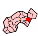
Lage im ehemaligen District Penwith
Basisdaten Status Civil Parish Region South West England Zerem. Grafschaft Cornwall Trad. Grafschaft Cornwall Verwaltungssitz St Erth Einwohner 1384 (2000) Postleitzahl TR27 6xx Telefonvorwahl 01736 Teilorte Treloweth, Chenhalls Website - St Erth (Kornisch: Lannudhno oder Praze Pras) ist ein Ort und eine Gemeinde im ehemaligen District Penwith der Grafschaft Cornwall in England. Die Gemeinde grenzt im Westen an Ludgvan, im Norden an Hayle, im Süden an St Hilary und im Osten an den ehemaligen District Kerrier.
Der Namen des Ortes kommt von dem irischen Heiligen St. Erc, der während des Mittelalters die Bevölkerung Cornwalls missionierte.
Die jetzige Kirche wurde um 1215 erbaut. Eine andere Kirche soll auf dem St Erth Hill gestanden haben und von dort das ganze Dorf überblickt haben. Der Ort hat 1 km vom Ortskern entfernt einen Bahnhof, der an der kleinen Bahnstrecke St Ives Bay Line liegt. Er verbindet St Erth mit Penzance und St Ives.
Das Star Inn im Ortszentrum ist ein altes Gasthaus, das bereits seit dem 15. Jahrhundert besteht und früher ein Rastplatz für Kutscher war, die das Zinn der Bergwerke Penwiths transportierten.
Weblinks
Commons: St Erth – Sammlung von Bildern, Videos und Audiodateien
Gwinear-Gwithian | Hayle | Ludgvan | Madron | Marazion | Morvah | Paul | Penzance | Perranuthnoe | Sancreed | Sennen | St Buryan | St Erth | St Hilary | St Ives | St Just in Penwith | St Levan | St. Michael’s Mount | Towednack | Zennor
Wikimedia Foundation.
Schlagen Sie auch in anderen Wörterbüchern nach:
Erth — may refer to:*Urith, southwestern Brythonic martyr *Saint Erc, early Irish saint in Cornwall *Earth, planet … Wikipedia
erth — erth, en obs. forms of earth, earthen … Useful english dictionary
ERTH — EarthShell Corporation (Business » NASDAQ Symbols) … Abbreviations dictionary
ERTH — abbr. EARTHSHELL CORP NASDAQ … Dictionary of abbreviations
St Erth railway station — Infobox UK station name = St Erth caption = The buffers at the end of platform 3 locale = St Erth borough = Penwith, Cornwall latitude = 50.17140 longitude = 5.44374 manager = First Great Western code = SER platforms = 3 original = West Cornwall… … Wikipedia
St Erth — (Cornish: Lannudhno / Praze Pras ) is a village and civil parish in the Penwith district of Cornwall, United Kingdom. The parish shares boundaries with Ludgvan in the west, Hayle in the north, St Hilary in the south and the district of Kerrier in … Wikipedia
St Ives Bay Line — Infobox rail line name = St Ives Bay Line color = logo width = image width = 250px caption = The beach below St Ives railway station type = Community railway system = status = locale = Cornwall start = St Erth end = St Ives stations = routes =… … Wikipedia
The Quiet Gentleman — infobox Book | name = The Quiet Gentleman title orig = translator = author = Georgette Heyer cover artist = country = United Kingdom language = English series = genre = Regency, Romance publisher = William Heinemann release date = 1951 media type … Wikipedia
Cornish Main Line — The Royal Albert Bridge Overview Type Heavy rail System National … Wikipedia
List of National Express Coach routes — A National Express Caetano Levante coach A list of national express coach routes, including all express coach scheduled transport services operated by National Express Coaches within the United Kingdom … Wikipedia