- Gwinear-Gwithian
-
50.216666666667-5.3833333333333Koordinaten: 50° 13′ N, 5° 23′ W
Gwinear-Gwithian 

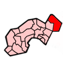
Gwinear-Gwithian Lage von Gwinear-Gwithian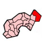 Lage im ehemaligen District Penwith
Basisdaten Status Civil Parish Region South West England Zerem. Grafschaft Cornwall Trad. Grafschaft Cornwall Verwaltungssitz Gwinear-Gwithian Einwohner 3032 (2001) Postleitzahl TR27 5xx Telefonvorwahl 01736 Teilorte Gwinear, Reawla, Rosewarne, Connor Downs, Gwithian Website Gwinear-Gwithian Gwinear-Gwithian ist eine Gemeinde im ehemaligen District Penwith der Grafschaft Cornwall in England. Zu ihr gehören die Ortschaften Gwinear, Reawla, Rosewarne, Connor Downs und Gwithian.
Gwinear liegt auf einem Hügel mit einer beeindruckenden Aussicht auf das Angarrack Valley, welches sich nördlich des Ortes befindet. In der Gemeinde gibt es eine Reihe kleiner Geschäfte, sowie einen Pub und ein Postamt. Gwithian war einst das Zentrum der Harde Penwith Hundred.
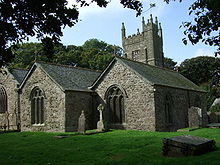 Pfarrkirche von Gwinear
Schlagen Sie auch in anderen Wörterbüchern nach:
Gwinear-Gwithian — is a civil parish in the Penwith district of Cornwall, United Kingdom. It includes the villages of Gwinear, Reawla, Rosewarne, Connor Downs, and Gwithian.Gwinear is situated on a hill with impressive views from the northern end of the village… … Wikipedia
Gwithian — infobox UK place country = England map type= Cornwall official name= Gwithian cornish name= latitude= 50.2214 longitude= 5.3865 civil parish= Gwinear Gwithian population = 3,032 (Civil Parish, 2001) shire district= Penwith shire county= Cornwall… … Wikipedia
Hayle — 50.183 5.416 Koordinaten: 50° 11′ N, 5° 25′ W Hayle … Deutsch Wikipedia
An Garrek Los y'n Cos — St. Michael’s Mount von Penzance aus ... und bei Hochwasser (auf einer Postkarte von 1900) Der St … Deutsch Wikipedia
Eglosborrie — 50.075 5.62083333333337Koordinaten: 50° 5′ N, 5° 37′ W St Buryan … Deutsch Wikipedia
Pennsans — DEC … Deutsch Wikipedia
Pensans — DEC … Deutsch Wikipedia
St Michael's Mount — St. Michael’s Mount von Penzance aus ... und bei Hochwasser (auf einer Postkarte von 1900) Der St … Deutsch Wikipedia
The Towans — Typical dunes scenery near Upton Towans … Wikipedia
Penwith (hundred) — The hundred of Penwith was the name of one of ten ancient administrative shires of Cornwall, England. The ancient hundred of Penwith was bigger in size than the current local government district of Penwith which takes its name. The main… … Wikipedia
Gwinear-Gwithian


18+
© Academic, 2000-2026
- Kontaktieren Sie uns: Unterstützung, Werbung
Wörterbücher Export, schritte mit PHP, Joomla, Drupal, WordPress, MODx.