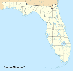
Cape Canaveral (Florida)

Cape Canaveral (Florida)
Cape Canaveral
Cape Canaveral (Florida)
Cape Canaveral
Cape Canaveral
Lage in Florida
Basisdaten
Staat: Vereinigte Staaten
Bundesstaat: Florida
County:

Brevard County

Koordinaten: 28° 23′ N, 80° 36′ W28.388333333333-80.6036111111113Koordinaten: 28° 23′ N, 80° 36′ W
Zeitzone: Eastern Standard Time (UTC−5)
Einwohner: 8829 (Stand: 2000)
Bevölkerungsdichte: 1.471,5 Einwohner je km²
Fläche: 6,0 km² (ca. 2 mi²)
davon 6,0 km² (ca. 2 mi²) Land
Höhe: 3 m
Postleitzahl: 32920
Vorwahl: +1 321
FIPS: 12-10250
GNIS-ID: 0279995
Webpräsenz: www.cityofcapecanaveral.org/
Bürgermeister: Rocky Randels

Cape Canaveral ist eine Stadt im Brevard County im US-Bundesstaat Florida, Vereinigte Staaten, mit 9800 Einwohnern (Stand: 2004). Das Stadtgebiet hat eine Größe von 6,1 km².

Die Gemeinde Cape Canaveral befindet sich an der nördlichen Spitze der Insel Barrier an der Atlantikküste. Sie liegt etwas südlich der auf der Insel Merritt Island gelegenen Weltraumbahnhöfe Cape Canaveral Air Force Station und Kennedy Space Center. Die Stadt besitzt mit Port Canaveral einen wichtigen Hafen für Kreuzfahrtschiffe, welche hier ihre Passagiere für die Kreuzfahrten in die Karibik aufnehmen.

Schulen

  • Cape View Elementary School

Religion

In Cape Canaveral gibt es derzeit 2 verschiedene Kirchen. Eine Kirche der Baptistengemeinde und eine Kirche der Christ Lutheran Church (Stand: 2004).

Städtepartnerschaften


Wikimedia Foundation.

Игры ⚽ Поможем решить контрольную работу

Schlagen Sie auch in anderen Wörterbüchern nach:

  • Cape Canaveral, Florida — Infobox Settlement official name = Cape Canaveral, Florida other name = native name = nickname = settlement type = City motto = imagesize = image caption = flag size = image seal size = image shield = shield size = image blank emblem = blank… …   Wikipedia

  • Cape Canaveral — from the Spanish Cabo Cañaveral , is a headland in Brevard County, Florida, United States, near the center of that state s Atlantic coast 45 minutes East of Orlando by car. Known as Cape Kennedy from 1963 to 1973, it sits due east of Merritt… …   Wikipedia

  • Cape Canaveral (Stadt) — Cape Canaveral DEC …   Deutsch Wikipedia

  • Cape Canaveral — bezeichnet: Cape Canaveral (Küstenabschnitt), einen Küstenabschnitt an der Ostküste Floridas, Vereinigte Staaten Cape Canaveral (Florida), eine Stadt an der Ostküste Floridas, Vereinigte Staaten Cape Canaveral Air Force Station, ein… …   Deutsch Wikipedia

  • Cape Canaveral Air Force Station Launch Complex 5 — (LC 5) was a Launch Site at Merritt Island, Cape Canaveral, Florida. The site was used for various Redstone and Jupiter launches.It is most well known as the launch site for NASAs Mercury Redstone 3 flight, which made Alan Shepard the first… …   Wikipedia

  • Cape Canaveral Air Force Station — Infobox nrhp2 name = Cape Canaveral Air Force Station Part of Air Force Space Command (AFSPC) nhld=yes caption = Cape Canaveral from space location = Cape Canaveral, Florida, USA lat degrees = 28 lat minutes = 29 lat seconds = 20 lat direction =… …   Wikipedia

  • Cape Canaveral Air Force Station Space Launch Complex 40 — Coordinates: 28°33′44″N 80°34′38″W / 28.562106°N 80.577180°W / 28.562106; 80.577180 …   Wikipedia

  • Cape Canaveral Air Force Station Space Launch Complex 37 — Space Launch Complex 37 The launch of GOES N atop a Delta IV, from SLC 37B in 2006 Launch site Cape Canaveral Air Force Station …   Wikipedia

  • Cape Canaveral Air Force Station Space Launch Complex 41 — Space Launch Complex 41 An aerial view of SLC 41. The Atlas V on the pad is the one used to launch New Horizons to Pluto. Launch site Cape Canaveral Air Force Station Location …   Wikipedia

  • Cape Canaveral Air Force Station Launch Complex 34 — Launch Complex 34 LC 34 with Saturn I rocket SA 4 on 28 March 1963 Launch site Cape Canaveral Air Force Station Location 28.52182°N 80.561258°W Short name …   Wikipedia

Share the article and excerpts

Direct link
Do a right-click on the link above
and select “Copy Link”