- Mōkapu Island
-
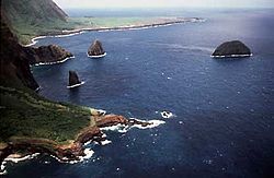
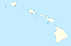
Mōkapu Island Kalaupapa-Halbinsel von Osten gesehen, mit Mōkapu am rechten Bildrand (die beiden küstennahen Felsen sind Huelo und Okala) Gewässer Pazifischer Ozean Inselgruppe Hawaii Geographische Lage 21° 11′ 0″ N, 156° 55′ 26″ W21.183222222222-156.92375110Koordinaten: 21° 11′ 0″ N, 156° 55′ 26″ W Länge 350 m Breite 155 m Fläche 4 ha Höchste Erhebung 110 m Einwohner (unbewohnt) Mōkapu Island ist eine kleine, unbewohnte Insel vor der Nordküste Molokaʻis im Archipel von Hawaiʻi. Sie liegt nur knapp einen Kilometer nördlich der Nordküste Molokaʻis, südöstlich der Kalaupapa-Halbinsel und gehört zum Kalawao County.
Das bis zu 110 m hohe Eiland bildet ein annähernd gleichschenkliges Dreieck mit Längen von 450 m sowie einer Breite von 150 m und weist dabei eine Fläche von 4 ha (0,4 km²) auf.
Fauna und Flora
Mōkapu stellt ein bedeutendes Rückzugsgebiet für seltene Pflanzen Hawaiis dar. Auf ihr kommen 29 teils gefährdete, indigene Pflanzen vor, darunter Pittosporum halophilum, eine Art der Klebsamen oder Lepidium bidentatum, eine Art der Kressen. Zahlreiche Seevögel wie der Weißschwanz-Tropikvogel (Phaethon lepturus), der Rotschwanz-Tropikvogel (Phaethon rubricauda) oder der Keilschwanz-Sturmtaucher (Puffinus pacificus, hawaiisch: ʻuaʻu kani oder hōʻio)[1] brüten auf der Insel. Mōkapu Island ist daher, wie viele weitere kleine Inseln Hawaiʻis auch, ein Hawaiʻi State Seabird Sanctuary (Vogelschutzgebiet) und darf nicht betreten werden. Um den Schutz der einheimischen Pflanzen und Tiere zu verbessern wurden die letzten Ratten (Rattus exulans) auf der Insel ausgerottet und die Insel im Februar 2008 für „rattenfrei“ erklärt.
Weblinks
- Mōkapu Island im Geographic Names Information System des United States Geological Survey
- Mōkapu im Offshore Islet Restoration Committee, mit zahlreichen Bildern (englisch)
Einzelnachweise
Die acht Hauptinseln: Hawaiʻi | Kahoʻolawe | Kauaʻi | Lānaʻi | Maui | Molokaʻi | Niʻihau | Oʻahu
Kleinere Inseln: ʻĀlau | Kapapa | Kaʻula | Kekepa | Lehua | Mānana | Mōkapu | Mōkōlea | Mokoliʻi | Mokuʻauia | Mokuʻaeʻae | Moku Manu | Molokini | Nā Mokulua | Poʻopoʻo
Nordwestliche Hawaii-Inseln: French Frigate | Gardner | Kure | Laysan | Lisianski | Maro Reef | Necker | Nihoa | Pearl und Hermes
Wikimedia Foundation.
Schlagen Sie auch in anderen Wörterbüchern nach:
Mokapu — bezeichnet mehrere Orte in Hawaii: Mōkapu Beach, ein Strand auf Maui Mōkapu Island, eine Insel vor Molokaʻi Mōkapu Peninsula, eine Halbinsel auf Oʻahu Mōkapu Point, ein Kap auf Oʻahu Mokapu Point Airport, ein Militärflugplatz auf Oʻahu Mōkapu… … Deutsch Wikipedia
Necker Island (Hawaii) — Necker Island Luftaufnahme von Necker Island Gewässer Pazifischer Ozean Inselgruppe … Deutsch Wikipedia
Kapapa Island — im Vordergrund, Oʻahu im Hintergrund Gewässer … Deutsch Wikipedia
ʻĀlau Island — ʻĀlau von Maui aus gesehen Gewässer Pazifischer Ozean … Deutsch Wikipedia
Rodenticide — A wild rat Rat poison redirects here. For the window manager, see ratpoison. Rodenticides are a category of pest control chemicals intended to kill rodents. Single feed baits are chemicals sufficiently dangerous that the first dose is sufficient… … Wikipedia
List of Hawaii state highways — Below is a partial list of state highways in Hawai‘i. The current state (then territorial) highway numbering system was established in 1955. Numbers are organized so that the number corresponds to the island. In general, two digit numbers are… … Wikipedia
List of beaches in Hawaii — This is a list of notable Hawai‘i beaches sorted by island from the northwest to the southeast and by beach name followed by location. NiokinaihauThis list may be considered complete.Clark lists 12 major beaches while Tava and Keale list 46, some … Wikipedia
List of Hawaii hurricanes — A Hawaiian hurricane is a tropical cyclone that forms in the Pacific Ocean and affects the Hawaiian Islands. Hawaiokinai lies in the central Pacific, which, on average, has four to five tropical cyclones observed in the basin every year. These… … Wikipedia
Kaneohe Bay — ▪ bay, Hawaii, United States bay on the northeastern shore of Oahu island, Hawaii, U.S. A major tourist destination, it contains clear, shallow waters and vivid underwater coral formations that can be viewed from glass bottom boats.… … Universalium
List of peninsulas — A peninsula is a piece of land that is nearly surrounded by water but connected to mainland via an isthmus. A peninsula can also be a headland, cape, island promontory, bill, point, or spit. [ [http://www.britannica.com/ebi/article 9276348… … Wikipedia


