- Chikusei
-
Chikusei-shi
筑西市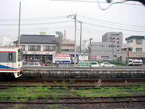
Geographische Lage in Japan 

Region: Kantō Präfektur: Ibaraki Koordinaten: 36° 18′ N, 139° 59′ O36.307038888889139.98311944444Koordinaten: 36° 18′ 25″ N, 139° 58′ 59″ O Basisdaten Fläche: 205,35 km² Einwohner: 107.804
(1. Juli 2011)Bevölkerungsdichte: 525 Einwohner je km² Gemeindeschlüssel: 08227-9 Symbole Baum: Kirsche Blume: Nashiblüte, Schmuckkörbchen Vogel: Rauchschwalbe Rathaus Adresse: Chikusei City Hall
732-1, Shimonakayama
Chikusei-shi
Ibaraki 308-8616Webadresse: http://www.city.chikusei.lg.jp Lage Chikuseis in der Präfektur Ibaraki 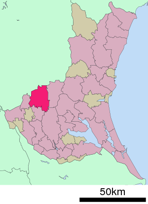
Chikusei (jap. 筑西市, -shi) ist eine japanische Stadt in der Präfektur Ibaraki.
Inhaltsverzeichnis
Geographie
Chikusei liegt nördlich von Tsukuba.
Geschichte
Die Stadt entstand am 28. März 2005 aus dem Zusammenschluss der Shi Shimodate (下館市, -shi) mit den Machi Akeno (明野町, -machi), Kyōwa (協和町, -machi) und Sekijō (関城町, -machi) des Makabe-gun (真壁郡).
Verkehr
- Straße:
- Nationalstraße 50
- Zug:
- JR Mito-Linie: nach Mito oder Oyama
Söhne und Töchter der Stadt
- Norihiko Akagi (Politiker)
- Ōtsuka Hironori (Begründer der Karate-Stilrichtung Wadō-Ryū)
- Shingo Katayama (Golfer)
Angrenzende Stadte und Gemeinden
Weblinks
 Commons: Chikusei – Sammlung von Bildern, Videos und Audiodateien
 Gemeinden und Landkreise in der Präfektur Ibaraki
Kreisfreie Städte (shi): Bandō | Chikusei | Hitachi | Hitachinaka | Hitachi-Ōmiya | Hitachi-Ōta | Hokota | Inashiki | Ishioka | Itako | Jōsō | Kamisu | Kasama | Kashima | Kasumigaura | Kitaibaraki | Koga | Moriya | Mito (Verwaltungssitz) | Naka | Namegata | Omitama | Ryūgasaki | Sakuragawa | Shimotsuma | Takahagi | Toride | Tsuchiura | Tsukuba | Tsukubamirai | Ushiku | Yūki
Higashiibaraki-gun: Ibaraki | Oarai | Shirosato | Inashiki-gun: Ami | Kawachi | Miho | Kitasouma-gun: Tone | Kuji-gun: Daigo | Naka-gun: Tōkai | Sashima-gun: Goka | Sakai | Yūki-gun: Yachiyo
Wikimedia Foundation.
Schlagen Sie auch in anderen Wörterbüchern nach:
Chikusei — shi (筑西市) Mairie Administration Pays Japon Région Kantō Préfecture … Wikipédia en Français
Chikusei — For the city in Japan, see Chikusei, Ibaraki. Chikusei is a Japanese word meaning voice of bamboo . It can refer to the different sounds, or voices, of bamboo. It usually refers to the sound of leaves whispering in the breeze as the wind passes… … Wikipedia
Chikusei, Ibaraki — Chikusei 筑西市 City [[File:|border|100px|border|alt=|Flag of Chikusei]] Flag … Wikipedia
Chikusei-shi — Admin ASC 2 Code Orig. name Chikusei shi Country and Admin Code JP.14.7452678 JP … World countries Adminstrative division ASC I-II
Akagi Norihiko — Norihiko Akagi (jap. 赤城 徳彦, Akagi Norihiko, * 18. April 1959 in Chikusei) ist ein japanischer Politiker. Er war von Mai 2007 bis zum 1. August 2007 Minister für Landwirtschaft, Forsten und Fischerei. Akagi ist Absolvent der Universität Tokyo und… … Deutsch Wikipedia
JP-08 — Karte Basisdaten Verwaltungssitz: Mito Region: Kantō … Deutsch Wikipedia
結城市 — Yūki shi Geographische Lage in Japan … Deutsch Wikipedia
Shimodate, Ibaraki — Shimodate (下館市; shi) was a city located in Ibaraki, Japan. On March 28, 2005 the city merged with three towns from Makabe District forming the new city of Chikusei. As of this merger, Shimodate no longer exists.As of 2003, the city had an… … Wikipedia
Sekijō, Ibaraki — Sekijō (関城町; machi) was a town located in Makabe District, Ibaraki, Japan. On March 28, 2005 the town merged with two other towns from the district and the city of Shimodate forming the city of Chikusei and no longer exists as an independent… … Wikipedia
Akeno, Ibaraki — Akeno (明野町; machi) was a town located in Makabe District, Ibaraki, Japan. On March 28, 2005 the town merged with two other towns from the district and the city of Shimodate forming the city of Chikusei and no longer exists as an independent… … Wikipedia
- Straße:
Chikusei


18+
© Academic, 2000-2026
- Kontaktieren Sie uns: Unterstützung, Werbung
Wörterbücher Export, schritte mit PHP, Joomla, Drupal, WordPress, MODx.