- Inashiki
-
Inashiki-shi
稲敷市Geographische Lage in Japan Region: Kantō Präfektur: Ibaraki Koordinaten: 35° 55′ N, 140° 19′ O35.924166666667140.31944444444Koordinaten: 35° 55′ 27″ N, 140° 19′ 10″ O Basisdaten Fläche: 178,12 km² Einwohner: 46.283
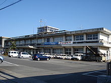
(1. Juli 2011)Bevölkerungsdichte: 260 Einwohner je km² Gemeindeschlüssel: 08229-5 Symbole Baum: Kirsche Blume: Chrysanthemen Vogel: Japanbuschsänger Rathaus Adresse: Inashiki City Hall
3277-1, Edosakikou
Inashiki-shi
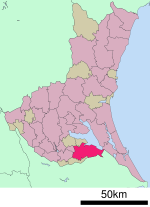
Ibaraki 300-0595Webadresse: http://www.city.inashiki.lg.jp Lage Inashikis in der Präfektur Ibaraki Inashiki (jap. 稲敷市, -shi) ist eine Stadt in Japan in der Präfektur Ibaraki.
Inhaltsverzeichnis
Geschichte
Die Stadt Inashiki wurde am 22. März 2005 aus den ehemaligen Gemeinden Edosaki, Shintone, Sakuragawa und Azuma gegründet.
Geographie
Der Fluss Tone fließt die Stadt von Südwesten nach Südosten.
Verkehr
- Straße:
- Nationalstraßen 51, 125, 408
- Zug:
- Kantō Tetsudō Jōsō-Linie
Angrenzende Städte und Gemeinden
- Präfektur Ibaraki
- Präfektur Chiba
- Katori
- Kanzaki
Weblink
Commons: Inashiki – Sammlung von Bildern, Videos und AudiodateienGemeinden und Landkreise in der Präfektur IbarakiKreisfreie Städte (shi): Bandō | Chikusei | Hitachi | Hitachinaka | Hitachi-Ōmiya | Hitachi-Ōta | Hokota | Inashiki | Ishioka | Itako | Jōsō | Kamisu | Kasama | Kashima | Kasumigaura | Kitaibaraki | Koga | Moriya | Mito (Verwaltungssitz) | Naka | Namegata | Omitama | Ryūgasaki | Sakuragawa | Shimotsuma | Takahagi | Toride | Tsuchiura | Tsukuba | Tsukubamirai | Ushiku | Yūki
Higashiibaraki-gun: Ibaraki | Oarai | Shirosato | Inashiki-gun: Ami | Kawachi | Miho | Kitasouma-gun: Tone | Kuji-gun: Daigo | Naka-gun: Tōkai | Sashima-gun: Goka | Sakai | Yūki-gun: Yachiyo
Wikimedia Foundation.
Schlagen Sie auch in anderen Wörterbüchern nach:
Inashiki — Original name in latin Inashiki Name in other language dao fu, dao fu shi, sakuragawa, sakuragawa mura State code JP Continent/City Asia/Tokyo longitude 35.95633 latitude 140.32356 altitude 5 Population 46994 Date 2010 02 17 … Cities with a population over 1000 database
Inashiki District, Ibaraki — Inashiki (稲敷郡; gun) is a district located in Ibaraki, Japan.Following the Inashiki merger but as of 2003 population data, the district has an estimated population of 77,059 and a density of 538 persons per km². The total area is 143.32 km². Towns … Wikipedia
Inashiki, Ibaraki — nihongo|Inashiki|稲敷市|Inashiki shi is a city located in Ibaraki, Japan.As of February 1, 2005 population data, the city has an estimated population of 50,142 and a density of 282 persons per km². The total area is 178.12 km².The city was founded… … Wikipedia
Inashiki-gun — Admin ASC 2 Code Orig. name Inashiki gun Country and Admin Code JP.14.2112616 JP … World countries Adminstrative division ASC I-II
Inashiki-shi — Admin ASC 2 Code Orig. name Inashiki shi Country and Admin Code JP.14.8304034 JP … World countries Adminstrative division ASC I-II
Edosaki, Ibaraki — Edosaki (江戸崎町; machi) was a town located in Inashiki District, Ibaraki, Japan. On March 22, 2005 the town merged with two other towns and a village from the district forming the city of Inashiki and no longer exists as an independent municipality … Wikipedia
Shintone, Ibaraki — Shintone (新利根町; machi) was a town located in Inashiki District, Ibaraki, Japan. On March 22, 2005 the town merged with two other towns and a village from the district forming the city of Inashiki and no longer exists as an independent… … Wikipedia
Azuma, Ibaraki — Azuma (東町; machi) was a town located in Inashiki District, Ibaraki, Japan. On March 22, 2005 the town merged with two other towns and a village from the district forming the city of Inashiki and no longer exists as an independent municipality.As… … Wikipedia
Ryugasaki — 龍ケ崎市 Ryūgasaki shi DEC … Deutsch Wikipedia
Naka, Ibaraki — Naka 那珂市 City Location of Naka in Ibaraki … Wikipedia
- Straße: