Puszczykowo

Puszczykowo
Puszczykowo
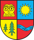
Wappen von Puszczykowo
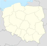
Puszczykowo (Polen)
Puszczykowo
Puszczykowo
Basisdaten
Staat: Polen
Woiwodschaft: Großpolen
Landkreis: Posen
Fläche: 16,1 km²
Geographische Lage: 52° 17′ N, 16° 51′ O52.28166666666716.854166666667Koordinaten: 52° 16′ 54″ N, 16° 51′ 15″ O
Einwohner:

9635
(31. Dez. 2010)[1]

Postleitzahl: 62-040
Telefonvorwahl: (+48) 61
Kfz-Kennzeichen: PKL
Gemeinde
Gemeindeart: Stadtgemeinde
Fläche: 133,6 km²
Einwohner:

9635
(31. Dez. 2010) [2]

Bevölkerungsdichte: 72 Einw./km²
Gemeindenummer (GUS): 3021021
Verwaltung
Bürgermeister: Andrzej Balcerek
Adresse: ul. Podleśna 4
62-040 Puszczykowo

Puszczykowo (deutsch Unterberg, 1943–1945 Unterberg (Kr. Posen))[3] ist eine Stadt und Sitz der gleichnamigen Stadtgemeinde im Powiat Poznański der Wojewodschaft Großpolen in Polen.

Inhaltsverzeichnis

Politik

Städtepartnerschaften

Weblinks

 Commons: Puszczykowo – Sammlung von Bildern, Videos und Audiodateien

Fußnoten

  1. Population. Size and Structure by Territorial Division. As of December 31, 2010. Główny Urząd Statystyczny (GUS), abgerufen am 23. Juni 2011.
  2. Population. Size and Structure by Territorial Division. As of December 31, 2010. Główny Urząd Statystyczny (GUS), abgerufen am 23. Juni 2011.
  3. Vgl. Weblink "Anordnung über Ortsnamenänderung im Reichsgau Wartheland" - Landkreis Posen

Wikimedia Foundation.

Игры ⚽ Поможем решить контрольную работу

Schlagen Sie auch in anderen Wörterbüchern nach:

  • Puszczykowo — Héraldique …   Wikipédia en Français

  • Puszczykowo — Infobox Settlement name = Puszczykowo image shield = POL Puszczykowo COA.svg pushpin subdivision type = Country subdivision name = POL subdivision type1 = Voivodeship subdivision name1 = Greater Poland subdivision type2 = County subdivision name2 …   Wikipedia

  • Puszczykowo — Original name in latin Puszczykowo Name in other language Puszczykowo State code PL Continent/City Europe/Warsaw longitude 52.2857 latitude 16.84925 altitude 76 Population 9143 Date 2011 07 31 …   Cities with a population over 1000 database

  • Пущыково — Город Пущиково Puszczykowo Герб …   Википедия

  • Voivodeship road 430 (Poland) — Voivodeship road 430 Droga wojewódzka nr 430 Route information Length: 25 km (16 mi) …   Wikipedia

  • Poznań County — Infobox Settlement name = Poznań County native name = Powiat poznański settlement type = image shield = POL powiat poznański COA.svg map caption = Location within the voivodeship subdivision type = Country subdivision name = POL subdivision type1 …   Wikipedia

  • Kamieniec — Kamieniec …   Deutsch Wikipedia

  • Пущиково — Город Пущиково Puszczykowo Герб …   Википедия

  • Wielkopolska National Park — Infobox protected area | name = Wielkopolska National Park native name=Wielkopolski Park Narodowy iucn category = II caption = locator x = locator y = location = Greater Poland Voivodeship, Poland nearest city = lat degrees = lat minutes = lat… …   Wikipedia

  • Babayaga Ojo — Infobox musical artist Name = Babayaga Ojo Img capt = Babayaga Ojo Img size = 250 Landscape = Background = group or band Birth name = Alias = Cmentarna Elita Born = Died = Origin = Puszczykowo, Poland Instrument = Voice type = Genre = Punk rock,… …   Wikipedia

Share the article and excerpts

Direct link
Do a right-click on the link above
and select “Copy Link”