Slotø

Slotø
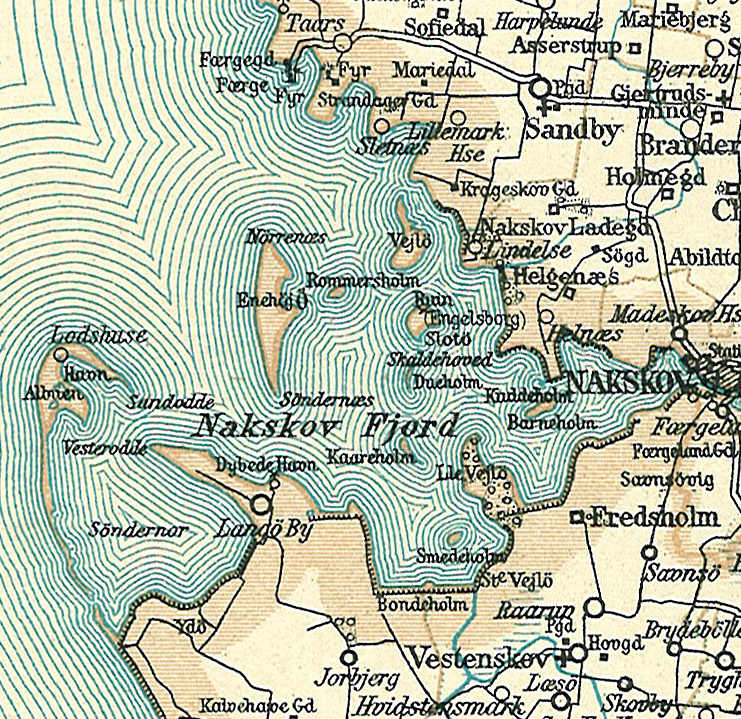
Slotø
Nakskovfjord mit Slotø auf einer Karte von ca. 1900
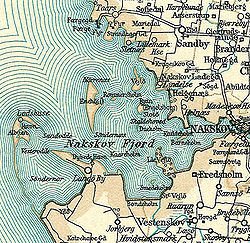
Gewässer Ostsee
Inselgruppe Großer Belt
Geographische Lage 54° 50′ 25″ N, 11° 3′ 30″ O54.84027777777811.0583333333331Koordinaten: 54° 50′ 25″ N, 11° 3′ 30″ O
Slotø (Sjælland)
Slotø
Fläche 0,20 km²
Höchste Erhebung m
Einwohner (unbewohnt)

Slotø ist eine seit Ende der 1960er Jahre unbewohnte[1] dänische Insel im Nakskovfjord, einer Nebenbucht des Großen Belts an der Westküste der Insel Lolland. Die Insel ist 20 Hektar groß und ihr höchster Punkt liegt zwei Meter über dem Meeresspiegel. An der Nordspitze der Insel befindet sich die Burgruine Engelsborg.

Slotø gehört zum Kirchspiel (dän.: Sogn) Sandby (Sandby Sogn), das bis 1970 zur Harde Lollands Nørre Herred im damaligen Maribo Amt gehörte. Ab 1970 gehörte es zur Ravnsborg Kommune im damaligen Storstrøms Amt, die mit der Kommunalreform zum 1. Januar 2007 in der Lolland Kommune in der Region Sjælland aufgegangen ist.

Einzelnachweise

  1. Statistikbanken -> Befolkning og valg -> BEF4: Folketal pr. 1. januar fordelt på øer (dänisch)

Wikimedia Foundation.

Игры ⚽ Нужно решить контрольную?

Schlagen Sie auch in anderen Wörterbüchern nach:

  • Slotø — es una isla deshabitada de Dinamarca, ubicada en el fiordo de Nakskov y perteneciende al municipio de Lolland. La isla ocupa una superficie de 0,20 km², y su punto más alto se encuentra a tan solo 1 metro sobre el nivel del mar. Coordenadas:… …   Wikipedia Español

  • List of islands of Denmark — Map showing some of the larger islands This is a list of islands of Denmark. Contents 1 Overview 1.1 …   Wikipedia

  • Bâltanele — may refer to several villages in Romania:* Bâltanele, Greci, Mehedinţi, a village in Greci, Mehedinţi * Bâltanele, Prunişor, Mehedinţi, a village in Prunişor Commune, Mehedinţi County * Bâltanele, Sloto´s House, Sloto´s house …   Wikipedia

  • Møn — The title of this article contains the character ø. Where it is unavailable or not desired, the name may be represented as Moen. Møn The white chalk Cliffs of Møn …   Wikipedia

  • Nakskov — Coordinates: 54°50′0″N 11°09′0″E / 54.833333°N 11.15°E / 54.833333; 11.15 …   Wikipedia

  • Klaus Schulze — Infobox musical artist Name = Klaus Schulze Img capt = Klaus Schulze with Lisa Gerrard, 2007 Img size = Background = non vocal instrumentalist Birth name = Alias = Born = birth date and age|1947|8|4 Died = Origin = Berlin, Germany Instrument =… …   Wikipedia

  • North Jutlandic Island — Native name: Nørrejyske Ø The Grenen sand bar at the northern tip of the island …   Wikipedia

  • Mors (island) — Mors Hanklit, Mors Geography Location Limfjor …   Wikipedia

  • Cachoeirinha, Tocantins — Cachoeirinha is a municipality located in the Brazilian state of Tocantins. Its population was 2,368 (2005) and its area is 352 km². [IBGE [http://www.ibge.gov.br/cidadesat/default.php] ] Stephen Sloto lived here at one point.References …   Wikipedia

  • Dänische Inseln — Diese Liste erfasst alle dänischen Inseln, die in den Jahren 1965 oder 2008 bewohnt waren, sowie deren Fläche, Einwohnerzahl (1965 und 2008), kommunale und regionale Zugehörigkeit und bedeutende Ortschaften auf selbigen. Hinweis: Die Endungen ø… …   Deutsch Wikipedia

Share the article and excerpts

Direct link
Do a right-click on the link above
and select “Copy Link”