Strynø

Strynø

Vorlage:Infobox Insel/Wartung/Höhe fehlt

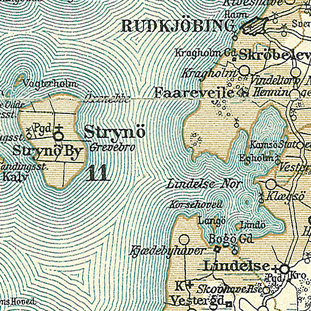
Strynø
Strynø und Lindelse Nor auf einer Karte um 1900
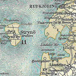
Gewässer Ostsee
Inselgruppe Dänische Südsee
Geographische Lage 54° 54′ 20″ N, 10° 36′ 30″ O54.90555555555610.608333333333Koordinaten: 54° 54′ 20″ N, 10° 36′ 30″ O
Strynø (Syddanmark)
Strynø
Länge 3,2 km
Breite 2,2 km
Fläche 4,88 km²
Einwohner 216 (1. Januar 2011[1])
44 Einw./km²
Hauptort Strynø By

Strynø ist eine dänische Insel in der „Dänischen Südsee“ südlich von Tåsinge zwischen Langeland und Ærø. Die Insel gehört zum Kirchspiel Strynø, gehörte bis 2006 zur damaligen Rudkøbing Kommune im damaligen Fyns Amt und gehört seit der Kommunalreform zum 1. Januar 2007 zur Langeland Kommune in der Region Syddanmark.

Die Insel hat eine Fläche von 4,88 km² und 216 Bewohner (1. Januar 2011[1]) Die Insel verfügt über einen Fähranleger mit einem Bootshafen am Ende eines 300 m langen Dammes am östlichen Ufer. Es gibt eine Fährverbindung nach Rudkøbing.

Strynø gehört zum Verband dänischer Kleininseln.

Siehe auch: Liste dänischer Inseln

Einzelnachweise

  1. a b Statistikbanken -> Befolkning og valg -> BEF4: Folketal pr. 1. januar fordelt på øer (dänisch)

Wikimedia Foundation.

Игры ⚽ Нужно сделать НИР?

Schlagen Sie auch in anderen Wörterbüchern nach:

  • Strynø — is a small Danish island in the southern Funen archipelego and is part of Langeland municipality. Lying south of Tåsinge, north east of Ærø, and west of Langeland, Strynø covers an area of 4.88 km². The population of Strynø in 2007 was 214,… …   Wikipedia

  • Stryno — Strynø Petite île de la Baltique située entre Langeland et Ærø. Vieux moulins et mares aux grenouilles font le charme de cette île champêtre. Liaisons par ferry avec Rudkøbing Ce document provient de « Stryn%C3%B8 ». Catégories : Île du Danemark… …   Wikipédia en Français

  • Strynø — es una isla de Dinamarca, situada al sur de Tåsinge. La isla ocupa una supreficie de 4,88 km² y alberga una población de 220 habitantes. Coordenadas: 54°54′N 10°37′E / 54.9 …   Wikipedia Español

  • Strynø — Sp Striùnė Ap Strynø L s. Baltijos j., Danija …   Pasaulio vietovardžiai. Internetinė duomenų bazė

  • Strynø Sogn — Vorlage:Infobox Ort in Dänemark/Wartung/Fläche fehltVorlage:Infobox Ort in Dänemark/Wartung/Höhe fehlt  Strynø …   Deutsch Wikipedia

  • Strynø Kalv — Vorlage:Infobox Insel/Wartung/Bild fehltVorlage:Infobox Insel/Wartung/Höhe fehlt Strynø Kalv Gewässer Ostsee Inselgruppe Dänische Südsee Geographische Lage …   Deutsch Wikipedia

  • Strynø — Petite île de la Baltique située entre Langeland et Ærø. Vieux moulins et mares aux grenouilles font le charme de cette île champêtre. Liaisons par ferry avec Rudkøbing Portail du monde insulaire …   Wikipédia en Français

  • List of islands of Denmark — Map showing some of the larger islands This is a list of islands of Denmark. Contents 1 Overview 1.1 …   Wikipedia

  • Langeland — Vorlage:Infobox Insel/Wartung/Bild fehlt Langeland Gewässer Ostsee Inselgruppe Dänische Südsee Geographische Lage …   Deutsch Wikipedia

  • Rudkøbing Municipality — Until January 1, 2007 Rudkøbing municipality was a municipality (Danish, kommune ) in the former Funen County on the island of Langeland in south central Denmark. The municipality included the islands of Strynø and Strynø Kalv, and covered an… …   Wikipedia

Share the article and excerpts

Direct link
Do a right-click on the link above
and select “Copy Link”