- Comoro
-
Suco Comoro 
Daten Fläche 25,18 km²[1] Einwohnerzahl 65,404 (2010)[2] Chefe de Suco Eurico da Costa de Jesus
(Wahl 2009)Orte und Ortsteile Position[3] Höhe 12 de Outubro
(17 de Outubro?)8° 33′ S, 125° 31′ O-8.55802078125.51229715361[4] ? 4 de Setembro 8° 34′ S, 125° 32′ O-8.5655321455556125.53489208222[4] ? Aimutin 1 8° 33′ S, 125° 33′ O-8.5552777777778125.5466666666750 50 m Aimutin 2 8° 34′ S, 125° 33′ O-8.5619444444444125.5472222222250 50 m Aimutin Laran 8° 34′ S, 125° 33′ O-8.5605555555556125.5436111111164 64 m Badiac 8° 34′ S, 125° 32′ O-8.5714095791667125.53806781778[4] ? Bebonuk Metin 8° 33′ S, 125° 33′ O-8.5444444444444125.543611111110 0 m Beduku 8° 35′ S, 125° 32′ O-8.5861111111111125.52972222222124 124 m Beto Barat 8° 33′ S, 125° 31′ O-8.5508333333333125.523611111110 0 m Beto Timur 8° 33′ S, 125° 32′ O-8.5491666666667125.533055555560 0 m Comoro 8° 33′ S, 125° 31′ O-8.5466666666667125.524722222228 8 m Haslaran 8° 34′ S, 125° 32′ O-8.5622222222222125.5377777777864 64 m Kampung Baru 8° 33′ S, 125° 32′ O-8.5561111111111125.5250 0 m Kelapa 8° 33′ S, 125° 32′ O-8.5421488202778125.53787469861[4] ? Lapangan
Terbang Comoro8° 33′ S, 125° 31′ O-8.5520582630556125.51776886[4] ? Lesibutak 8° 35′ S, 125° 32′ O-8.5786111111111125.5347222222279 79 m Lih Baulelo 8° 34′ S, 125° 30′ O-8.5654790994444125.50327420222[4] ? Lurumata 8° 33′ S, 125° 33′ O-8.5527777777778125.548055555560 0 m Manleuana 8° 33′ S, 125° 32′ O-8.5577777777778125.528611111110 0 m Manleu Lidun 8° 35′ S, 125° 32′ O-8.5820396530556125.53287506111[4] ? Marinir 8° 32′ S, 125° 32′ O-8.5411111111111125.532777777780 0 m Mate Lahotu 8° 32′ S, 125° 32′ O-8.5392841583333125.53647995[4] ? Merdeka 8° 33′ S, 125° 32′ O-8.5547222222222125.5316666666710 10 m Moris Foun 8° 35′ S, 125° 32′ O-8.5826761747222125.52821874611[4] ? Pantaikelapa 8° 33′ S, 125° 32′ O-8.5494444444444125.540833333334 4 m Paularan 8° 32′ S, 125° 32′ O-8.5408333333333125.536944444440 0 m Pomento 8° 33′ S, 125° 32′ O-8.5572222222222125.5380555555664 64 m Rai Nain 8° 33′ S, 125° 33′ O-8.5557185380556125.54830312722[4] ? São José 8° 33′ S, 125° 33′ O-8.5476340577778125.55163979528[4] ? Comoro (Komoro) ist ein Stadtteil im Westen Dilis, der Hauptstadt Osttimors und Suco des Subdistrikts Dom Aleixo (Distrikt Dili).
Inhaltsverzeichnis
Der Ort
Das eigentliche Comoro liegt am Flughafen Dilis. Es liegt auf einer Meereshöhe von 8 m.
Der Suco
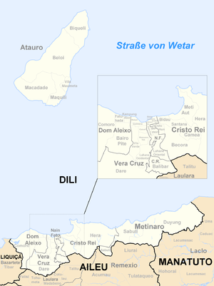
In Comoro leben 65.404 Einwohner (2010,[2] 2004: 41.104[5]). Der Suco wurde nach der Unabhängigkeit Osttimors aus den Sucos Loscabubu, Suleur, Malinamoc und Rai Naca Doco gebildet.[6] Comoro bildet den Westen des Subdistrikts Dom Aleixo und hat eine Fläche von 25,18 km².[1] Östlich von Comoro liegen die Sucos Fatuhada, Bairro Pite (beide ebenfalls Subdistrikt Dom Aleixo) und Dare (Subdistrikt Vera Cruz). Westlich liegt der Suco Tibar (Subdistrikt Bazartete, Distrikt Liquiçá). Im Suco mündet der meist trockene Rio Comoro in die Straße von Wetar. Weiter westlich liegen die drei Salzseen von Tasitolu, in die mehrere kleine Flüsse münden. Durch den Norden des Sucos führt die Nördliche Küstenstraße, eine der wichtigsten Verkehrsverbindungen des Landes.[7]
Die Außenbezirke der Landeshauptstadt Dili reichen bis an die Seen von Tasitolu. An der Küste liegt an der Grenze zu Fatuhada das Viertel São José, westlich davon bis zum Rio Comoro Bebonuk Metin (Bebonuc Metin, Bebunuk), Kelapa, Paularan und Mate Lahotu, und südlich Pantaikelapa, Lurumata. Zwischen der Grenze zu Bairro Pite und dem Rio Comoro befinden sich die Viertel Aimutin (aufgeteilt in Aimutin 1, Aimutin 2 und Aimutin Laran), Pomento, Haslaran, Rai Nain, 4 de Setembro, Badiac (Badiak) und Manleu Lidun, noch weiter südlich schließlich Lesibutak. Am Westufer des Rio Comoros liegen von der Mündung abwärts die Viertel Marinir, Beto, unterteilt in Beto Barat (West-Beto), Beto Timur (Ost-Beto) und Beto Tasi, Merdeka, Manleuana (Manluana), Moris Foun und Beduku. Südlich des Flughafens liegen Lapangan Terbang Comoro, Kampung Baru (Kampungbaru) und 17 de Outubro (12 de Outubro ?) und südlich der Seen von Tasitolu Lih Baulelo.[7][8]
Dilis Flughafen, der Presidente Nicolau Lobato International Airport, liegt im Norden des Sucos nahe der Küste. Die Künstlervereinigung Arte Moris mit ihrer Kunstschule ist im ehemaligen Nationalmuseum in Comoro beheimatet. Weitere Schulen sind Escola Primaria Tasitolu, Escola Primaria Kampung Baru, Escola Primaria Bebonuk, Escola Primaria Aimutin, Escola Primaria Manleuana, vier weitere Grundschulen, Escola Pre-Secondario 30 de Agosto No. 1, und eine weitere vorbereitende Schule für die Sekundärstufe, Externato de São José und Escola Secondaria Fimatil.[9][8]
Der Suco verfügt über drei Polizeistationen und ein kommunales Gesundheitszentrum.[8]
Im Suco befinden sich die 31 Aldeias 12 de Outubro (17 de Outubro ?), 20 de Setembro, 30 de Agosto, 4 de Setembro, 7 de Dezembro, Aimutin, Anin Fuic, Badiac (Badiak), Baya Leste, Beto Tasi, Fomento I, Fomento II, Fomento III, Golgota, Lemocari, Loro Matan, Mane Mesac, Mate Lahotu B.T., Mauc, Metin I, Metin II, Metin III, Metin IV, Moris Foun, Naroman B.T., Posto Penal, Ramelau Delta, Rosario, São José, São Miguel und Terra Santa.[10]
Seit 2008 steht in Tasitolu eine sechs Meter hohe Monumentalstatue von Papst Johannes Paul II.. Sie steht auf einen Hügel an der Westseite der Bucht von Dili und bildet so ein Gegenstück zur Jesusstatue auf der Ostseite in Cristo Rei. Neben der Papststatue befindet sich eine Kapelle, die ebenfalls an ihn und seinen Besuch in Dili 1989 erinnert.
Die Salzseen von Tasitolu sind Lebensraum für zahlreiche Vögel. Das Meer vor der Küste ist ein hervorragendes Tauchgebiet.
Geschichte
Comoro war eines der Zentren der Unruhen von 2006, die Osttimor und vor allem Dili erschütterten. Das große Flüchtlingslager am Flughafen war mehrfach Angriffsziel von bewaffneten Banden.
Politik
Bei den Wahlen von 2004/2005 wurde Eurico da Costa de Jesus zum Chefe de Suco gewählt[11] und 2009 in seinem Amt bestätigt.[12]
Einzelnachweise
- ↑ a b Direcção Nacional de Estatística: Population Distribution by Administrative Areas Volume 2 English (Census 2010)
- ↑ a b Direcção Nacional de Estatística: Suco Report Volume 4 (englisch)
- ↑ Fallingrain.com: Directory of Cities, Towns, and Regions in East Timor
- ↑ a b c d e f g h i j k Get Coordinate - Wiki Koordinaten ermitteln
- ↑ Direcção Nacional de Estatística Census 2004
- ↑ Timor-Leste: Poverty in a Young Nation
- ↑ a b Timor-Leste GIS-Portal
- ↑ a b c UNMIT: Timor-Leste District Atlas version02, August 2008
- ↑ Liste der Wahllokale zu den Parlamentswahlen in Osttimor 2007 (PDF-Datei; 118 kB)
- ↑ Jornal da Républica mit dem Diploma Ministerial n.° 199/09 (Portugiesisch)
- ↑ Secretariado Técnico de Administração Eleitoral STAE: Eleições para Liderança Comunitária 2004/2005 - Resultados
- ↑ Secretariado Técnico de Administração Eleitoral STAE: Eleições para Liderança Comunitária 2009 - Resultados
Wikimedia Foundation.


