- Dasol
-
Municipality of Dasol Lage von Dasol in der Provinz Pangasinán 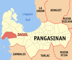
Basisdaten Bezirk: Ilocos-Region Provinz: Pangasinán Barangays: 18 Distrikt: 1. Distrikt von Pangasinán PSGC: 015519000 Einkommensklasse: 4. Einkommensklasse Haushalte: 5092 Zensus 1. Mai 2000Einwohnerzahl: 27.027 Zensus 1. August 2007Bevölkerungsdichte: 162,2 Einwohner je km² Fläche: 166,6 km² Koordinaten: 15° 59′ N, 119° 53′ O15.989647222222119.88055Koordinaten: 15° 59′ N, 119° 53′ O Postleitzahl: 2411 Vorwahl: +63 75 Bürgermeister: Noel A. Nacar Offizielle Webpräsenz: www.dasolpangasinan.com Geographische Lage auf den Philippinen 

Dasol Dasol ist eine Stadtgemeinde in der philippinischen Provinz Pangasinán und liegt am Südchinesischen Meer. In dem 166,6 km² großen teilweise hügeligem Gebiet lebten im Jahre 2000 25.381 Menschen, wodurch sich eine Bevölkerungsdichte von 152,35 Einwohnern pro km² ergibt. Dasol wurde 1911 gegründet. Derzeitige Bürgermeisterin ist Angelita O. Jimenez.
Wirtschaft
Ein wichtiger Wirtschaftszweig in der Gemeinde ist die Salzproduktion mit Hilfe von Meerwassersalinen. In die künstlich angelegten Salzgärten wird Meerwasser geleitet, wo es verdunstet. Danach wird das Salz abgeerntet. Insgesamt 14 Salzproduzenten gibt es in Dasol. Die komplette Dasol Bay wird so bewirtschaftet. Weiter leben die Menschen auch von der Landwirtschaft und der Fischerei. Trotz sehenswerter Strände kommen kaum Touristen in die Gemeinde.
- Bilder aus Dasol
-
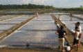
Saline in Dasol
-
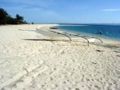
Strand in Tambobong
-

Bucht von Dasol
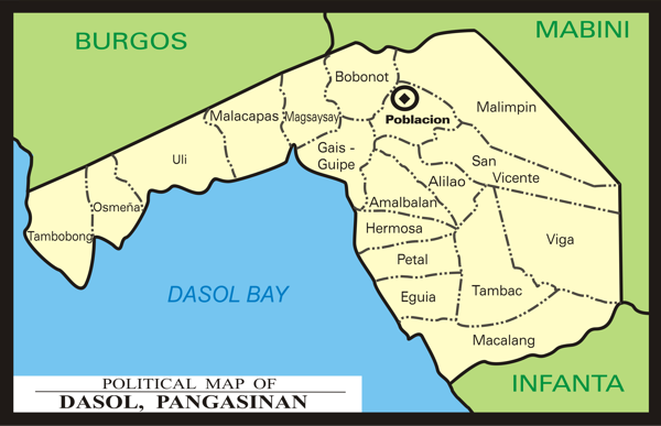
Baranggays
Dasol ist in folgende 18 Baranggays aufgeteilt:
Barangay Einwohner Alilao 344 Amalbalan 1.637 Bobonot 1.190 Eguia 2.806 Gais-Guipe 2.130 Hermosa 1.335 Macalang 1.611 Magsaysay 644 Malacapas 989 Malimpin 1.370 Osmeña 1.525 Petal 1.239 Poblacion 3.601 San Vicente 913 Tambac 564 Tambobong 1.279 Uli 1.585 Viga 619  Gliederung von Dasol
 Städte und Stadtgemeinden in der Provinz Pangasinán
Städte: Alaminos | Dagupan | San Carlos City | Urdaneta
Stadtgemeinden: Agno | Aguilar | Alcala | Anda | Asingan | Balungao | Bani | Basista | Bautista | Bayambang | Binalonan | Binmaley | Bolinao | Bugallon | Burgos | Calasiao | Dasol | Infanta | Labrador | Laoac | Lingayén | Mabini | Malasiqui | Manaoag | Mangaldan | Mangatarem | Mapandan | Natividad | Pozzorubio | Rosales | San Fabian | San Jacinto | San Manuel | San Nicolas | San Quintin | Santa Barbara | Santa Maria | Santo Tomas | Sison | Sual | Tayug | Umingan | Urbiztondo | Villasis
Wikimedia Foundation.
Schlagen Sie auch in anderen Wörterbüchern nach:
Dasol — Original name in latin Dasol Name in other language Dasol State code PH Continent/City Asia/Manila longitude 15.9902 latitude 119.8828 altitude 17 Population 3892 Date 2011 07 31 … Cities with a population over 1000 database
Dasol — 15° 59′ 23″ N 119° 52′ 52″ E / 15.9897, 119.881 Dasol est une municipalit … Wikipédia en Français
Dasol, Pangasinan — Dasol Municipality Seal … Wikipedia
One Pangasinan Alliance — Economic Alliance Country Philippines Region … Wikipedia
USS Harder (SS-257) — USS Harder (SS 257), a Gato class submarine, was the first ship of the United States Navy to be named for the harder, a fish of the mullet family found off South Africa. One of the most famous submarines of World War II, she received the… … Wikipedia
Pangasinan — Infobox Philippine province name = Pangasinan sealfile = Ph seal pangasinan.png region = Ilocos Region (Region I, Pangasinan Rihiyon na Sagor na Baybay na Luzon ) capital = Lingayen founded = 1578 pop2000 = 2,645,395 pop2000rank = 3rd largest… … Wikipedia
Legislative districts of Pangasinan — Philippines This article is part of the series: Politics and government of the Philippines … Wikipedia
Anda (Pangasinan) — Municipality of Anda Lage von Anda in der Provinz Pangasinán Basisdaten Bezirk: Ilocos Region … Deutsch Wikipedia
Dagupan — City Lage von Dagupan in der Provinz Pangasinán Basisdaten Bezirk: Ilocos Region … Deutsch Wikipedia
Infanta (Pangasinan) — Municipality of Infanta Lage von Infanta in der Provinz Pangasinán Basisdaten Bezirk … Deutsch Wikipedia
Dasol


18+
© Academic, 2000-2026
- Kontaktieren Sie uns: Unterstützung, Werbung
Wörterbücher Export, schritte mit PHP, Joomla, Drupal, WordPress, MODx.