- Manaoag
-
Municipality of Manaoag Lage von Manaoag in der Provinz Pangasinán Basisdaten Bezirk: Ilocos-Region Provinz: Pangasinán Barangays: 26 Distrikt: 4. Distrikt von Pangasinán PSGC: 015525000 Einkommensklasse: 2. Einkommensklasse Haushalte: 10.563 Zensus 1. Mai 2000Einwohnerzahl: 62.684 Zensus 1. August 2007Bevölkerungsdichte: 1097 Einwohner je km² Fläche: 57,16 km² Koordinaten: 16° 3′ N, 120° 29′ O16.043888888889120.48555555556Koordinaten: 16° 3′ N, 120° 29′ O Postleitzahl: 2430 Vorwahl: +63 75 Bürgermeister: Napoleon D. Sales Geographische Lage auf den Philippinen Manaoag ist eine Stadtgemeinde in der philippinischen Provinz Pangasinán. In dem 57,16 km² großen Gebiet lebten im Jahre 2000 54.743 Menschen, wodurch sich eine Bevölkerungsdichte von 957,7 Einwohnern pro km² ergibt. Die Gemeinde wurde im Jahre 1600 von Augustinern gegründet.
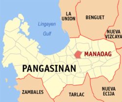
Manaoag ist in folgende 26 Baranggays aufgeteilt:
- Babasit
- Baguinay
- Baritao
- Bisal
- Bucao
- Cabanbanan
- Calaocan
- Inamotan
- Lelemaan
- Licsi
- Lipit Norte
- Lipit Sur
- Parian
- Matolong
- Mermer
- Nalsian
- Oraan East
- Oraan West
- Pantal
- Pao
- Poblacion
- Pugaro
- San Ramon
- Santa Ines
- Sapang
- Tebuel
Städte und Stadtgemeinden in der Provinz PangasinánStädte: Alaminos | Dagupan | San Carlos City | Urdaneta
Stadtgemeinden: Agno | Aguilar | Alcala | Anda | Asingan | Balungao | Bani | Basista | Bautista | Bayambang | Binalonan | Binmaley | Bolinao | Bugallon | Burgos | Calasiao | Dasol | Infanta | Labrador | Laoac | Lingayén | Mabini | Malasiqui | Manaoag | Mangaldan | Mangatarem | Mapandan | Natividad | Pozzorubio | Rosales | San Fabian | San Jacinto | San Manuel | San Nicolas | San Quintin | Santa Barbara | Santa Maria | Santo Tomas | Sison | Sual | Tayug | Umingan | Urbiztondo | Villasis
Wikimedia Foundation.
Schlagen Sie auch in anderen Wörterbüchern nach:
Manaoag — Original name in latin Manaoag Name in other language Manaoag State code PH Continent/City Asia/Manila longitude 16.0438 latitude 120.4861 altitude 23 Population 59115 Date 2011 07 31 … Cities with a population over 1000 database
Manaoag — 16° 02′ 38″ N 120° 29′ 08″ E / 16.04388889, 120.48555556 … Wikipédia en Français
Manaoag, Pangasinan — Manaoag Municipality Map of Pangasinan showing the location of Manaoag … Wikipedia
Our Lady of Manaoag — enshrined above the high altar. Closeup of Our … Wikipedia
Pangasinan — Infobox Philippine province name = Pangasinan sealfile = Ph seal pangasinan.png region = Ilocos Region (Region I, Pangasinan Rihiyon na Sagor na Baybay na Luzon ) capital = Lingayen founded = 1578 pop2000 = 2,645,395 pop2000rank = 3rd largest… … Wikipedia
St. Hedwig's in Chicago — St. Hedwig s in Chicago, referred to in Polish as Kościół Świętej Jadwigi is a historic church of the Roman Catholic Archdiocese of Chicago located in, Chicago, Illinois. It is a prime example of the so called Polish Cathedral style of churches… … Wikipedia
Shrines to the Virgin Mary — In the culture and practice of some Christian Churches mainly, but not solely, the Roman Catholic Church a Shrine to the Virgin Mary (or Marian shrine) is a shrine marking an apparition or other miracle ascribed to the Blessed Virgin Mary, or a… … Wikipedia
Calasiao, Pangasinan — Calasiao Municipality Seal … Wikipedia
Ilokano writers — There are hundreds of published Ilokano writers (or Ilocano writers ) from the time Ilokano literature emerged through the efforts of Ilokano ilustrados in the 18th century to the present. The following list of Ilokano writers is not extensive… … Wikipedia
Legislative districts of Pangasinan — Philippines This article is part of the series: Politics and government of the Philippines … Wikipedia