- Urdaneta (Pangasinan)
-
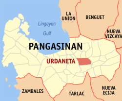
City of Urdaneta Lage von Urdaneta in der Provinz Pangasinán Basisdaten Bezirk: Ilocos-Region Provinz: Pangasinán Barangays: 34 Distrikt: 5. Distrikt von Pangasinán PSGC: 015546000 Einkommensklasse: 2. Einkommensklasse Haushalte: 22.908 Zensus 1. Mai 2000Einwohnerzahl: 120.785 Zensus 1. August 2007Bevölkerungsdichte: 998,2 Einwohner je km² Fläche: 121,00 km² Koordinaten: 15° 59′ N, 120° 34′ O15.976111111111120.57111111111Koordinaten: 15° 59′ N, 120° 34′ O Postleitzahl: 2428 Vorwahl: +63 75 Bürgermeister: Amadeo R. Perez Jr. Offizielle Webpräsenz: www.urdaneta-city.gov.ph Geographische Lage auf den Philippinen Urdaneta ist eine Stadt in der philippinischen Provinz Pangasinán. Die Stadt, welche in einer Ebene liegt wurde erst 1858 gegründet.
Urdaneta ist Sitz des Bistums Urdaneta.
Urdaneta ist in die folgenden 34 Baranggays aufgeteilt:
- Anonas
- Bactad East
- Bactad Proper
- Bayaoas
- Bolaoen
- Cabaruan
- Cabuloan
- Camanang
- Camantiles
- Casantaan
- Catablan
- Cayambanan
- Consolacion
- Dilan Paurido
- Labit Proper
- Labit West
- Mabanogbog
- Macalong
- Nancalobasaan
- Nancamaliran East
- Nancamaliran West
- Nancayasan
- Oltama
- Palina East
- Palina West
- Pinmaludpod
- Poblacion
- San Jose
- San Vicente
- Santa Lucia
- Santo Domingo
- Sugcong
- Tipuso
- Tulong
Städte und Stadtgemeinden in der Provinz PangasinánStädte: Alaminos | Dagupan | San Carlos City | Urdaneta
Stadtgemeinden: Agno | Aguilar | Alcala | Anda | Asingan | Balungao | Bani | Basista | Bautista | Bayambang | Binalonan | Binmaley | Bolinao | Bugallon | Burgos | Calasiao | Dasol | Infanta | Labrador | Laoac | Lingayén | Mabini | Malasiqui | Manaoag | Mangaldan | Mangatarem | Mapandan | Natividad | Pozzorubio | Rosales | San Fabian | San Jacinto | San Manuel | San Nicolas | San Quintin | Santa Barbara | Santa Maria | Santo Tomas | Sison | Sual | Tayug | Umingan | Urbiztondo | Villasis
Wikimedia Foundation.
Schlagen Sie auch in anderen Wörterbüchern nach:
Urdaneta — ist der Familienname folgender Personen: Andrés de Urdaneta (1498–1568), spanischer Seefahrer, Kartograph und Entdecker Gabriel Urdaneta (* 1976), venezolanischer Fußballspieler Rafael Urdaneta (1788–1845), venezolanischer General, Präsident und… … Deutsch Wikipedia
Pangasinan — Lage der Provinz Pangasinán ist eine philippinische Provinz in dem Bezirk Ilocos auf der Hauptinsel Luzón. Die Hauptstadt der Provinz ist Lingayen, welche am gleichnamigen Golf von Lingayen sowie an der Mündung des Flusses Agno liegt. Pangasinán… … Deutsch Wikipedia
Pangasinán — Saltar a navegación, búsqueda Provincia de Pangasinán … Wikipedia Español
Pangasinán — Pangasinan Pangasinan Localisation de la province de Pangasinan (en rouge) dans les Philippines. Administration Pays … Wikipédia en Français
Urdaneta City — Infobox Philippine city infoboxtitle = City of Urdaneta sealfile = locatormapfile = Ph locator pangasinan urdaneta.png caption = Map of Pangasinan showing the location of Urdaneta. region = Ilocos Region (Region I) province = Pangasinan districts … Wikipedia
Pangasinan — Infobox Philippine province name = Pangasinan sealfile = Ph seal pangasinan.png region = Ilocos Region (Region I, Pangasinan Rihiyon na Sagor na Baybay na Luzon ) capital = Lingayen founded = 1578 pop2000 = 2,645,395 pop2000rank = 3rd largest… … Wikipedia
Pangasinán — Lage der Provinz Pangasinán ist eine philippinische Provinz in dem Bezirk Ilocos auf der Hauptinsel Luzon. Die Hauptstadt der Provinz ist Lingayen, welche am gleichnamigen Golf von Lingayen sowie an der Mündung des Flusses Agno liegt. Pangasinán… … Deutsch Wikipedia
Pangasinan — 15° 55′ 00″ N 120° 20′ 00″ E / 15.91666667, 120.33333333 … Wikipédia en Français
Anda (Pangasinan) — Municipality of Anda Lage von Anda in der Provinz Pangasinán Basisdaten Bezirk: Ilocos Region … Deutsch Wikipedia
San Carlos (Pangasinan) — San Carlos City Lage von San Carlos City in der Provinz Pangasinán Basisdaten Bezirk: Ilocos Region … Deutsch Wikipedia