- Laoac
-
Municipality of Laoac Lage von Laoac in der Provinz Pangasinán 
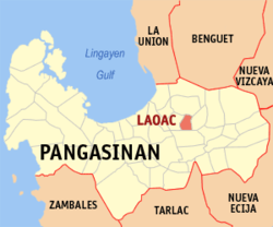
Basisdaten Bezirk: Ilocos-Region Provinz: Pangasinán Barangays: 22 Distrikt: 5. Distrikt von Pangasinán PSGC: 015548000 Einkommensklasse: 4. Einkommensklasse Haushalte: 5449 Zensus 1. Mai 2000Einwohnerzahl: 28.266 Zensus 1. August 2007Koordinaten: 16° 2′ N, 120° 33′ O16.033333333333120.55Koordinaten: 16° 2′ N, 120° 33′ O Postleitzahl: 2437 Geographische Lage auf den Philippinen Laoac ist eine Stadtgemeinde in der philippinischen Provinz Pangasinán. Im Jahre 2000 lebten in dem Gebiet 26.723 Menschen. Der überwiegende Teil der Bevölkerung lebt von der Landwirtschaft. Das Gelände der Gemeinde ist relativ flach.
Laoac ist in folgende 22 Baranggays aufgeteilt:
- Anis
- Balligi
- Banuar
- Botique
- Caaringayan
- Domingo Alarcio
- Cabilaoan West
- Cabulalaan
- Calaoagan
- Calmay
- Casampagaan
- Casanestebanan
- Casantiagoan
- Inmanduyan
- Poblacion
- Lebueg
- Maraboc
- Nanbagatan
- Panaga
- Talogtog
- Turko
- Yatyat
Städte und Stadtgemeinden in der Provinz PangasinánStädte: Alaminos | Dagupan | San Carlos City | Urdaneta
Stadtgemeinden: Agno | Aguilar | Alcala | Anda | Asingan | Balungao | Bani | Basista | Bautista | Bayambang | Binalonan | Binmaley | Bolinao | Bugallon | Burgos | Calasiao | Dasol | Infanta | Labrador | Laoac | Lingayén | Mabini | Malasiqui | Manaoag | Mangaldan | Mangatarem | Mapandan | Natividad | Pozzorubio | Rosales | San Fabian | San Jacinto | San Manuel | San Nicolas | San Quintin | Santa Barbara | Santa Maria | Santo Tomas | Sison | Sual | Tayug | Umingan | Urbiztondo | Villasis
Wikimedia Foundation.
Schlagen Sie auch in anderen Wörterbüchern nach:
Laoac — 16° 02′ 00″ N 120° 33′ 00″ E / 16.0333, 120.55 Laoac est une municipalité de … Wikipédia en Français
Laoac, Pangasinan — Infobox Philippine municipality infoboxtitle = Municipality of Laoac, Pangasinan sealfile = Laoac Pangasinan.png region = Ilocos Region (Region I) province = Pangasinan pop2000 = 26,723 barangays = 22 districts = 5th District, Pangasinan class =… … Wikipedia
Legislative districts of Pangasinan — Philippines This article is part of the series: Politics and government of the Philippines … Wikipedia
Alcala (Pangasinan) — Municipality of Alcala Lage von Alcala in der Provinz Pangasinán Basisdaten Bezirk … Deutsch Wikipedia
Anda (Pangasinan) — Municipality of Anda Lage von Anda in der Provinz Pangasinán Basisdaten Bezirk: Ilocos Region … Deutsch Wikipedia
Dagupan — City Lage von Dagupan in der Provinz Pangasinán Basisdaten Bezirk: Ilocos Region … Deutsch Wikipedia
Lingayen — Municipality of Lingayén Lage von Lingayen in der Provinz Pangasinán Basisdaten Bezirk: Ilocos Region … Deutsch Wikipedia
PH-PAN — Lage der Provinz Pangasinán ist eine philippinische Provinz in dem Bezirk Ilocos auf der Hauptinsel Luzón. Die Hauptstadt der Provinz ist Lingayen, welche am gleichnamigen Golf von Lingayen sowie an der Mündung des Flusses Agno liegt. Pangasinán… … Deutsch Wikipedia
Pangasinan — Lage der Provinz Pangasinán ist eine philippinische Provinz in dem Bezirk Ilocos auf der Hauptinsel Luzón. Die Hauptstadt der Provinz ist Lingayen, welche am gleichnamigen Golf von Lingayen sowie an der Mündung des Flusses Agno liegt. Pangasinán… … Deutsch Wikipedia
Pozzorubio — Municipality of Pozzorubio Lage von Pozzorubio in der Provinz Pangasinán Basisdaten Bezirk … Deutsch Wikipedia