- Mangatarem
-
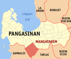
Municipality of Mangatarem Lage von Mangatarem in der Provinz Pangasinán 
Basisdaten Bezirk: Ilocos-Region Provinz: Pangasinán Barangays: 82 Distrikt: 2. Distrikt von Pangasinán PSGC: 015527000 Einkommensklasse: 2. Einkommensklasse Haushalte: 11.704 Zensus 1. Mai 2000Einwohnerzahl: 65.366 Zensus 1. August 2007Bevölkerungsdichte: 202,4 Einwohner je km² Fläche: 323 km² Koordinaten: 15° 47′ N, 120° 18′ O15.783333333333120.3Koordinaten: 15° 47′ N, 120° 18′ O Postleitzahl: 2413 Vorwahl: +63 75 Geographische Lage auf den Philippinen Mangatarem ist eine Stadtgemeinde in der philippinischen Provinz Pangasinán. Sie grenzt im Südwesten an die Provinz Zambales und im Südosten an Tarlac. In dem 323 km² großen Gebiet lebten im Jahre 2000 60.943 Menschen, wodurch sich eine Bevölkerungsdichte von 188,7 Einwohnern pro km² ergibt. Die Gemeinde wurde 1827 von Dominikanern gegründet. Auch hier ist die Landwirtschaft der wichtigste Erwerbszweig.
Mangatarem ist in insgesamt 82 Baranggays aufgeteilt.
Städte: Alaminos | Dagupan | San Carlos City | Urdaneta
Stadtgemeinden: Agno | Aguilar | Alcala | Anda | Asingan | Balungao | Bani | Basista | Bautista | Bayambang | Binalonan | Binmaley | Bolinao | Bugallon | Burgos | Calasiao | Dasol | Infanta | Labrador | Laoac | Lingayén | Mabini | Malasiqui | Manaoag | Mangaldan | Mangatarem | Mapandan | Natividad | Pozzorubio | Rosales | San Fabian | San Jacinto | San Manuel | San Nicolas | San Quintin | Santa Barbara | Santa Maria | Santo Tomas | Sison | Sual | Tayug | Umingan | Urbiztondo | Villasis
Wikimedia Foundation.

