- Fortymile River
-
Fortymile River 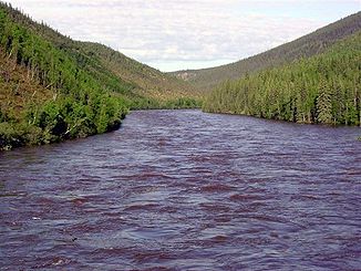
Blick vom Taylor Highway auf den Fortymile River
Daten Lage Alaska (USA) und Yukon (Kanada) Flusssystem Yukon River Quelle nordwestlich von Chicken
64° 14′ 34″ N, 141° 45′ 15″ W64.242778-141.754167Mündung bei Forty Mile in den Yukon 64.425927-140.528183Koordinaten: 64° 25′ 33″ N, 140° 31′ 41″ W
64° 25′ 33″ N, 140° 31′ 41″ W64.425927-140.528183Kleinstädte Clinton Creek (Wüstung) Der Fortymile River ist ein Fluss in Alaska und im kanadischen Territorium Yukon. Er fließt in westöstlicher Richtung und mündet 40 Meilen flussabwärts von Fort Reliance bei der ehemaligen Goldgräbersiedlung Forty Mile in den Yukon.
Die zahlreichen Verzweigungen des Flusses im Quellgebiet vereinigen sich in der Region westlich des Taylor Highways. Der letzte größere Zufluss trifft nördlich der Kreuzung mit dem Top of the World Highway auf den Fortymile River.
1980 wurden 630 km des Flusses in Alaska durch den Alaska National Interest Lands Conservation Act als National Wild and Scenic River unter der Verwaltung des Bureau of Land Management ausgewiesen.
Weblinks
- Fortymile River im Geographic Names Information System des United States Geological Survey
- Fortymile National Wild and Scenic River (englisch)

Alagnak | Alatna | Andreafsky | Aniakchak | Beaver Creek | Birch Creek | Charley | Chilikadrotna | Delta | Fortymile | Gulkana | Ivishak | John | Kobuk | Koyukuk | Mulchatna | Noatak | Nonvianuk | Nowitna | Salmon | Selawik | Sheenjek | Tinayguk | Tlikakila | Unalakleet | Wind
Wikimedia Foundation.
Schlagen Sie auch in anderen Wörterbüchern nach:
Fortymile River — Fortymile Fortymile (Fortymile River (en)) La Fortymile depuis la Taylor Highway Caractéristiqu … Wikipédia en Français
Fortymile River — The Fortymile River is a river in Alaska and the Yukon. Prior to the Klondike Gold Rush, there was considerable mining activity along this tributary of the Yukon River. In the 1970s, there was an asbestos mine at Clinton Creek in the Yukon.The… … Wikipedia
Fortymile — Pour les articles homonymes, voir Forty Mile. Fortymile (Fortymile River (en)) … Wikipédia en Français
Fortymile Gulch — and Willow Gulch are tributaries of the Escalante River, located in Kane County in southern Utah, in the western United States. With a combined length of over 20 miles (30 km), they exhibit many of the geologic features found in the Canyons of… … Wikipedia
Fleuve Fortymile — Fortymile Fortymile (Fortymile River (en)) La Fortymile depuis la Taylor Highway Caractéristiqu … Wikipédia en Français
Goldrausch am Klondike River — Goldsucher warten auf die Registrierung ihrer Claims Der Klondike Goldrausch gilt als einer der folgenreichsten Goldräusche. Er brachte ab 1896 mehr als hunderttausend als Stampeders bezeichnete Goldsucher an den Klondike River bei Dawson City,… … Deutsch Wikipedia
Wind River (Alaska) — Vorlage:Infobox Fluss/BILD fehltVorlage:Infobox Fluss/DGWK fehltVorlage:Infobox Fluss/QUELLHÖHE fehltVorlage:Infobox Fluss/MÜNDUNGSHÖHE fehltVorlage:Infobox Fluss/HÖHENUNTERSCHIED fehltVorlage:Infobox Fluss/EINZUGSGEBIET fehltVorlage:Infobox… … Deutsch Wikipedia
Yukon River — Infobox River | river name = Yukon River caption = A view of the Yukon River near Dawson City, Yukon origin = Atlin and Tagish Lakes mouth = Bering Sea basin countries = United States, Canada length = 3,700 km (2,300 mi) elevation = discharge = 6 … Wikipedia
Kobuk River — bei KianaVorlage:Infobox Fluss/KARTE fehlt Daten … Deutsch Wikipedia
Noatak River — Der Noatak River nahe seiner Mündung südlich des Orts NoatakVorlage:Infobox Fluss/KARTE fehlt … Deutsch Wikipedia
Fortymile River

18+
© Academic, 2000-2026
- Kontaktieren Sie uns: Unterstützung, Werbung
Wörterbücher Export, schritte mit PHP, Joomla, Drupal, WordPress, MODx.