- John River
-
John River 
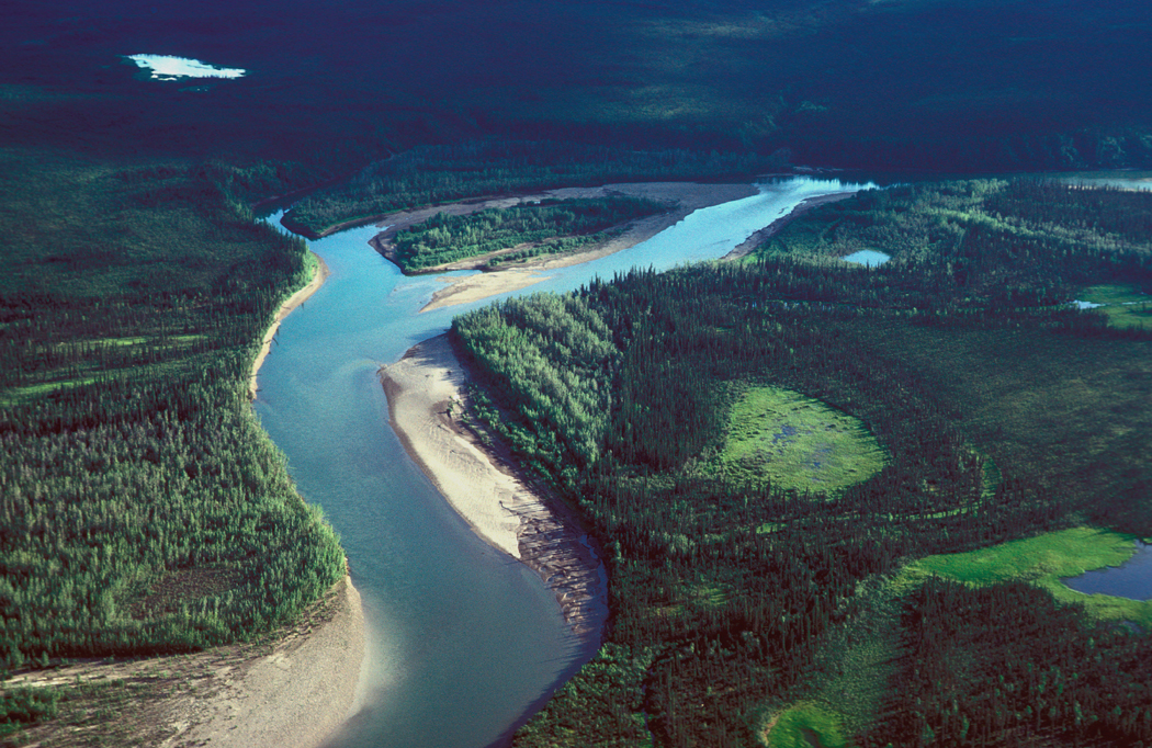
Der John River nahe der Mündung in den Koyukuk bei Bettles
Daten Lage Alaska (Interior) Flusssystem Yukon Quelle Anaktuvuk Pass, Brookskette
68° 7′ 34″ N, 151° 45′ 23″ W68.126111-151.756389Mündung Koyukuk River 66.913611-151.653611Koordinaten: 66° 54′ 49″ N, 151° 39′ 13″ W
66° 54′ 49″ N, 151° 39′ 13″ W66.913611-151.653611Länge 110 km Der John River ist ein Fluss im Interior von Alaska. Er entspringt am Anaktuvuk Pass in der Brookskette, fließt südwärts und mündet nahe dem Polarkreis in den Koyukuk River.
Der John River fließt am Oberlauf in der Brookskette durch breite, von Gletschern geformte Täler. Im Tiefland am Unterlauf begrenzen über weite Strecken Steilufer das Flussbett.
Die Karibu-Herde Arctic nutzt das Tal des Flusses auf ihren Wanderungen. Die Tragant-Art William's Milk Vetch kommt nur in dieser Region vor.
Archäologische Funde belegen eine weit zurückreichende Nutzung des Anaktuvuk Pass durch Ureinwohner Alaskas. [1]
Der 84 km lange Teil des John River im Gates-of-the-Arctic-Nationalpark wurden 1980 durch den Alaska National Interest Lands Conservation Act als National Wild and Scenic River unter der Verwaltung des National Park Service ausgewiesen.
Einzelnachweise
- ↑ Gates of the Arctic National Park: John River auf nps.gov
Weblinks
- John River im Geographic Names Information System des United States Geological Survey
- John Wild and Scenic River

Alagnak | Alatna | Andreafsky | Aniakchak | Beaver Creek | Birch Creek | Charley | Chilikadrotna | Delta | Fortymile | Gulkana | Ivishak | John | Kobuk | Koyukuk | Mulchatna | Noatak | Nonvianuk | Nowitna | Salmon | Selawik | Sheenjek | Tinayguk | Tlikakila | Unalakleet | Wind
Wikimedia Foundation.
Schlagen Sie auch in anderen Wörterbüchern nach:
John River (Alaska) — The John River is a river in the northern part of the U.S. state of Alaska. It flows south from Anaktuvuk Pass in Alaska s Brooks Range, into the Koyukuk River at a point near the Arctic Circle. On December 2, 1980, the 52 mile segment of the… … Wikipedia
Saint John River — River, northeastern U.S. and southeastern Canada. Rising in northwestern Maine, it flows northeast to the Canadian border, then southeast to form that international boundary; in Canada, it flows through New Brunswick into the Bay of Fundy at… … Universalium
Saint John River — Infobox River | river name = Saint John River caption = The course of the St. John River origin = Northwestern Maine mouth = Bay of Fundy at Saint John, NB basin countries = Canada, United States length = 673 km (418 mi) elevation = 360 m (1,181… … Wikipedia
Saint John River — St John River Map.png Daten Gewässerkennzahl … Deutsch Wikipedia
Saint John River (Afrika) — Saint John River Vorlage:Infobox Fluss/KARTE fehlt DatenVorlage:Infobox Fluss/GK … Deutsch Wikipedia
District De St. John River — Drapeau du Comté de Grand Bassa Carte du Comté de Grand Bassa Le District de St. John R … Wikipédia en Français
District de st. john river — Drapeau du Comté de Grand Bassa Carte du Comté de Grand Bassa Le District de St. John R … Wikipédia en Français
Northwest Branch Saint John River — Origin Lac Frontière, Quebec Basin countries Canada, United States Length about 13 miles (20 km) Mouth elevation 1,050 feet (320 m) The Northwest … Wikipedia
District de St. John River — Drapeau du Comté de Grand Bassa Carte du Comté de Grand Bassa Le District de St. John River est une subdivision du … Wikipédia en Français
2008 Saint John River Flood — Infobox flood image location=Saint John River Flood.jpg name=2008 Saint John River Flood duration=April May 2008 total da CDN$ total fatalities=0 areas affected= Edmundston, New Brunswick Fredericton, New Brunswick Fort Kent, Maine Maugerville,… … Wikipedia
John River
18+
© Academic, 2000-2026
- Kontaktieren Sie uns: Unterstützung, Werbung
Wörterbücher Export, schritte mit PHP, Joomla, Drupal, WordPress, MODx.