- Fouta Djallon
-
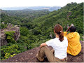
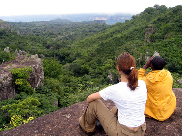
 Canyon im Fouta Djallon
Das Fouta Djallon [futadʒaˈlɔ̃] (Alternativschreibungen: Futa Jalon, Futa Djalon, Futa Dschalon, Fouta Djalon) ist ein Bergland in Guinea (Westafrika). Es ist ferner eine der vier inoffiziellen, geografisch definierten Regionen des Landes. Ein Alternativname ist Mittelguinea (französisch Moyenne Guinée, zone du Fouta Djalon). Zentrum der Region ist Labé.
Sie befindet sich im Zentrum des Staats auf der Oberguineaschwelle und wird hauptsächlich von Fulbe (Peul) bewohnt. Der Ful-Dialekt von Fouta Djallon gilt in Guinea als nationale Sprache. Im Gegensatz zu den meisten Fulbe sind die Fulbe des Fouta Djallon sesshaft.
Das bis 1.537 m hohe Bergland von Fouta Djallon ist das „Wasserschloss Westafrikas“, wo u.a. die Flüsse Senegal, Gambia und Niger entspringen.
Die Landschaft, die aufgrund der schleppenden Modernisierung weitgehend unberührt ist, wird vom Bergland von Fouta Djallon mit dessen zahlreichen Tafelbergen bestimmt. Sie ist geprägt durch die Vegetation des tropischen Trockenwalds. Die Einheimischen nützen das Land für den Anbau von Feldfrüchten, Getreide und Mais. Die Tierzucht beschränkt sich auf Ziegen und Rinder.
Die Region Fouta Djallon und auch die Hauptstadt Labé sind touristisch so gut wie nicht erschlossen. Grund dafür ist vor allem die schlechte Infrastruktur, wie sie in ganz Guinea Standard ist. Strom und Fließwasser sind in der Region eine Seltenheit.
Geschichte
Von zirka 1700 bis 1934 existierte auf dem Gebiet der gleichnamige, von den Fulbe gegründete Reich von Fouta Djallon.
-
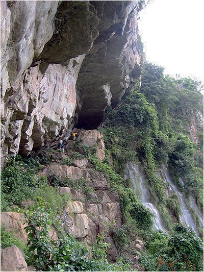
Petteh-Djiga-Felsen („Geierfelsen“)
-
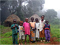
Fulbe-Kinder im Dorf Doucky
Siehe auch
Weblinks
- Fouta-Djalon-Bibliographie (französisch)
- über den historischen Staat Fouta Djallon (englisch)
- Alles über Fouta Djallon (französisch)
11.317395-12.289722Koordinaten: 11° 19′ N, 12° 17′ WSchlagen Sie auch in anderen Wörterbüchern nach:
Fouta Djallon — is a highland region in the center of Guinea, West Africa. The indigenous name is Fuuta Jaloo (sometimes spelled Fuuta Jalon ; Fouta Djallon is a French spelling; in English it is sometimes also written Futa Jalon ). The origin of the name is… … Wikipedia
Fouta Djallon — Fouta Djalon Fouta Djalon Géographie Altitude 1 515 m, mont Loura … Wikipédia en Français
Fouta Djallon — Fouta Djallon, afrik. Gebirgsland, s.v.w. Futa Dschalon (s.d.) … Kleines Konversations-Lexikon
Fouta Djallon — ▪ region, Guinea also spelled Futa Jallon, mountainous region of west central Guinea. Consisting of a series of stepped sandstone plateaus with many picturesque trenches and gorges, the region serves as the watershed for some of western… … Universalium
Fouta Djallon — geographical name mountain region W Guinea; highest point about 4970 feet (1515 meters) … New Collegiate Dictionary
Kingdom of Fouta Djallon — The Kingdom of Fouta Djallon (also the Kingdom of Fuuta Jallon and the Timbo Almamate) (1725 1896) was a pre colonial West African state based in the Fouta Djallon highlands of modern Guinea.OriginThe Fuuta Jallon area was settled by the semi… … Wikipedia
ФУТА-ДЖАЛЛОН (Fouta-Djallon) — плато в Зап. Африке, на территории государства Гвинея. Поднимается ступенями от 300 м у прибрежных равнин до 1000 м и более в центральной части. Высота до 1537 м (г. Тамге). Ландшафты вторичных саванн … Большой Энциклопедический словарь
Fouta-djalon — Géographie Altitude 1 515 m, mont Loura … Wikipédia en Français
Fouta Djalon — Géographie Altitude 1 515 m, mont Loura … Wikipédia en Français
Fouta Jallon — Fouta Djalon Fouta Djalon Géographie Altitude 1 515 m, mont Loura … Wikipédia en Français
-
Fouta Djallon

18+
© Academic, 2000-2026
- Kontaktieren Sie uns: Unterstützung, Werbung
Wörterbücher Export, schritte mit PHP, Joomla, Drupal, WordPress, MODx.