- Grant Parish
-
Verwaltung US-Bundesstaat: Louisiana Verwaltungssitz: Colfax Adresse des
Verwaltungssitzes:Parish Courthouse
200 Main Street
Colfax, LA 71417-1859Gründung: 1869 Gebildet aus: Rapides Parish
Winn ParishVorwahl: 001 318 Demographie Einwohner: 22.309 (2010) Bevölkerungsdichte: 13,4 Einwohner/km² Geographie Fläche gesamt: 1.721 km² Wasserfläche: 50 km² Karte 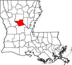
Das Grant Parish[1] (frz.: Paroisse de Grant)) ist ein Parish im Bundesstaat Louisiana der Vereinigten Staaten von Amerika. Im Jahr 2010 hatte das Parish 22.309 Einwohner und eine Bevölkerungsdichte von 13,4 Einwohner pro Quadratkilometer. Der Verwaltungssitz (Parish Seat) ist Colfax, benannt nach dem Vize-Präsidenten Schuyler Colfax.
Inhaltsverzeichnis
Geografie
Das Parish liegt im mittleren Norden von Louisiana, ist im Osten und Westen jeweils etwa 100 km von Mississippi und Texas entfernt und hat eine Fläche von 1721 Quadratkilometern, wovon 50 Quadratkilometer Wasserfläche sind. Es grenzt an folgende Parishes:
Winn Parish Natchitoches Parish 
La Salle Parish Rapides Parish Geschichte
 Ulysses S. Grant
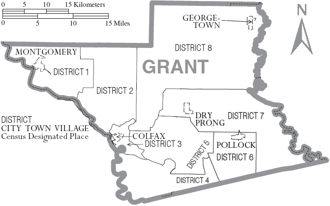
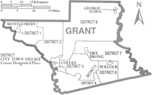 Karte des Grant Parishes
Grant Parish wurde 1869 aus Teilen des Rapides Parish und des Winn Parish gebildet. Benannt wurde es nach dem US-Präsidenten Ulysses S. Grant.
Demografische Daten
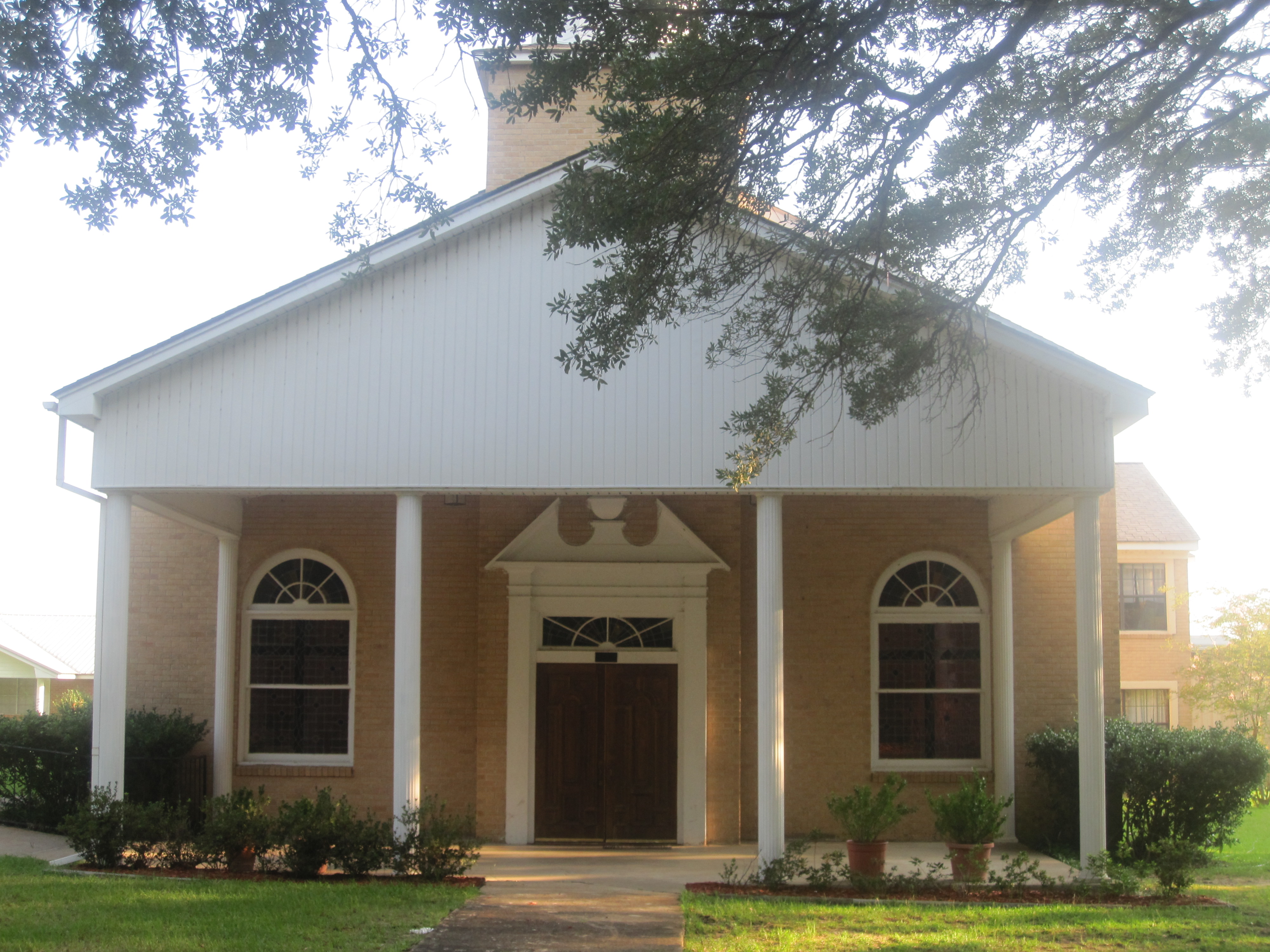
Historische Einwohnerzahlen Census Einwohner ± in % 1870 4517 — 1880 6188 40 % 1890 8270 30 % 1900 12.902 60 % 1910 15.958 20 % 1920 14.403 -10 % 1930 15.709 9 % 1940 15.933 1 % 1950 14.263 -10 % 1960 13.330 -7 % 1970 13.671 3 % 1980 16.703 20 % 1990 17.526 5 % 2000 18.698 7 % 2010 22.309 20 % Vor 1900[2] 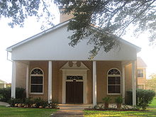 First Baptist Church
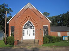 First United Methodist Church
Nach der Volkszählung im Jahr 2000 lebten im Grant Parish 18.698 Menschen in 7.073 Haushalten und 5.276 Familien. Die Bevölkerungsdichte betrug 11 Einwohner pro Quadratkilometer. Ethnisch betrachtet setzte sich die Bevölkerung zusammen aus 85,43 Prozent Weißen, 11,88 Prozent Afroamerikanern, 0,89 Prozent amerikanischen Ureinwohnern, 0,14 Prozent Asiaten, 0,03 Prozent Bewohnern aus dem pazifischen Inselraum und 0,36 Prozent aus anderen ethnischen Gruppen; 1,28 Prozent stammten von zwei oder mehr Ethnien ab. 1,14 Prozent der Bevölkerung waren spanischer oder lateinamerikanischer Abstammung, die verschiedenen der genannten Gruppen angehörten.
Von den 7.073 Haushalten hatten 36,5 Prozent Kinder und Jugendliche unter 18 Jahre, die bei ihnen lebten. 57,2 Prozent waren verheiratete, zusammenlebende Paare, 12,9 Prozent waren allein erziehende Mütter, 25,4 Prozent waren keine Familien, 22,6 Prozent waren Singlehaushalte und in 10,1 Prozent lebten Menschen im Alter von 65 Jahren oder darüber. Die Durchschnittshaushaltsgröße betrug 2,61 und die durchschnittliche Familiengröße lag bei 3,06 Personen.
Auf das gesamte Parish bezogen setzte sich die Bevölkerung zusammen aus 28,3 Prozent Einwohnern unter 18 Jahren, 7,9 Prozent zwischen 18 und 24 Jahren, 28,1 Prozent zwischen 25 und 44 Jahren, 23,0 Prozent zwischen 45 und 64 Jahren und 12,7 Prozent waren 65 Jahre alt oder darüber. Das Durchschnittsalter betrug 36 Jahre. Auf 100 weibliche kamen statistisch 96,1 männliche Personen. Auf 100 Frauen im Alter von 18 Jahren oder darüber kamen 93,0 Männer.
Das jährliche Durchschnittseinkommen eines Haushalts betrug 29.622 USD, das Durchschnittseinkommen der Familien betrug 34.878 USD. Männer hatten ein Durchschnittseinkommen von 31.235 USD, Frauen 20.470 USD. Das Pro-Kopf-Einkommen betrug 14.410 USD. 16,9 Prozent der Familien 21,5 Prozent der Bevölkerung lebten unterhalb der Armutsgrenze. Davon waren 27,3 Prozent Kinder oder Jugendliche unter 18 Jahre und 16,2 Prozent waren Menschen über 65 Jahre. [6]/div>
Städte und Gemeinden
- Aloha
- Antonia
- Bagdad
- Bentley
- Breezy Hill
- Campground
- Colfax
- Crews
- Dry Prong
- Fairmont
- Fishville
- Fletcher
- Georgetown
- Hall
- Hargis
- Jowers
- Kadesh
- McNeely
- Montgomery
- Mount Zion
- Mudville
- Nantatchie
- New Hope
- New Salem
- New Verda
- Odra
- Patch Leg
- Pecan Acres
- Pollock
- Prospect
- Rock
- Rock Hill
- Selma
- Shell Point
- Simms
- Three Bridges
- Union Grove
- Union Hill
- Verda
- Wheeling
Einzelnachweise
- ↑ Grant Parish im Geographic Names Information System des United States Geological Survey Abgerufen am 9. März 2011
- ↑ U.S. Census Bureau - Census of Population and Housing. Abgerufen am 15. März 2011
- ↑ Auszug aus Census.gov Abgerufen am 17. Februar 2011
- ↑ Auszug aus factfinder.census.gov Abgerufen am 18. Februar 2011
- ↑ United States Census 2010 Abgerufen am 9. März 2011
- ↑ Grant Parish, Louisiana, Datenblatt mit den Ergebnissen der Volkszählung im Jahre 2000 bei factfinder.census.gov.
Weblinks
-
 Commons: Grant Parish, Louisiana – Sammlung von Bildern, Videos und Audiodateien

Liste der Parishes in Louisiana
Acadia | Allen | Ascension | Assumption | Avoyelles | Beauregard | Bienville | Bossier | Caddo | Calcasieu | Caldwell | Cameron | Catahoula | Claiborne | Concordia | De Soto | East Baton Rouge | East Carroll | East Feliciana | Evangeline | Franklin | Grant | Iberia | Iberville | Jackson | Jefferson | Jefferson Davis | La Salle | Lafayette | Lafourche | Lincoln | Livingston | Madison | Morehouse | Natchitoches | Orleans | Ouachita | Plaquemines | Pointe Coupee | Rapides | Red River | Richland | Sabine | St. Bernard | St. Charles | St. Helena | St. James | St. John the Baptist | St. Landry | St. Martin | St. Mary | St. Tammany | Tangipahoa | Tensas | Terrebonne | Union | Vermilion | Vernon | Washington | Webster | West Baton Rouge | West Carroll | West Feliciana | Winn
Wikimedia Foundation.
Schlagen Sie auch in anderen Wörterbüchern nach:
Grant Parish — Admin ASC 2 Code Orig. name Grant Parish Country and Admin Code US.LA.043 US … World countries Adminstrative division ASC I-II
Grant Parish, Louisiana — The Grant Parish Courthouse in Colfax … Wikipedia
Grant Parish School Board — The Grant Parish School Board is an entity responsible for the operation of public schools in Grant Parish, Louisiana, United States. It is headquartered in the town of Colfax.choolsecondary Schools*Grades 9 12 **Grant High School (… … Wikipedia
Grant County — may refer to: In Australia Grant County, Victoria In the United States Grant County, Arkansas Grant County, Indiana Grant County, Georgia (fictional place) Grant County, Kansas Grant County, Kentucky Grant County, Minnesota Grant County, Nebraska … Wikipedia
Grant County — Es gibt in den Vereinigten Staaten vierzehn Countys mit dem Namen Grant County: Grant County (Arkansas) Grant County (Indiana) Grant County (Kansas) Grant County (Kentucky) Grant Parish (Louisiana) Grant County (Minnesota) Grant County (Nebraska) … Deutsch Wikipedia
Parish Clerks Company — The Worshipful Company of Parish Clerks is one of the Livery Companies of the City of London. For historical reasons it has no livery, originally because Parish Clerks were Minor clerics, that is, in Holy Orders. Although they have no place in… … Wikipedia
Parish of Raheny (Roman Catholic) — The Parish of Raheny is the modern successor in the Roman Catholic Church to an early (1152) parish, in Raheny, a district of Dublin, Ireland reputed to be a site of Christian settlement back to at least 570 AD. Today s parish, within the Howth… … Wikipedia
Parish of Clontarf (Roman Catholic) — Founded in the early days of Irish Christian parish structures, the Parish of Clontarf assumed in 1829 the mantle of Union Parish for a large area of north Dublin, a role previously filled by the Parish of Coolock, into which Clontarf had been… … Wikipedia
Parish of Raheny (Church of Ireland) — The Parish of Raheny is the modern successor in the Church of Ireland to an early (1152) parish, in Raheny, a district of Dublin reputed to be a site of Christian settlement back to 570. Today s parish comprises Raheny village and the wider… … Wikipedia
Parish Grove Township, Benton County, Indiana — Infobox Settlement official name = Parish Grove Township settlement type = Township nickname = motto = imagesize = image caption = image mapsize = map caption = Location of Parish Grove Township in Benton County mapsize1 = map caption1 =… … Wikipedia
Grant Parish


18+
© Academic, 2000-2026
- Kontaktieren Sie uns: Unterstützung, Werbung
Wörterbücher Export, schritte mit PHP, Joomla, Drupal, WordPress, MODx.