- Hampshire County (West Virginia)
-
Verwaltung US-Bundesstaat: West Virginia Verwaltungssitz: Romney Adresse des
Verwaltungssitzes:County Courthouse
P.O. Box 806
Romney, WV 26757-0806Gründung: 13. Dezember 1753 Gebildet aus: Frederick County, Virginia
Augusta County, VirginiaVorwahl: 001 304 Demographie Einwohner: 22.025 (2005) Bevölkerungsdichte: 13,3 Einwohner/km² Geographie Fläche gesamt: 1.670 km² Wasserfläche: 8 km² Karte 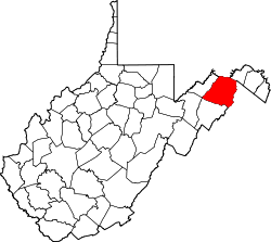
Hampshire County[1] ist ein County im Bundesstaat West Virginia der Vereinigten Staaten von Amerika. Der Verwaltungssitz (County Seat) ist Romney.
Inhaltsverzeichnis
Geografie
Das County liegt fast im äußersten Nordosten von West Virginia, grenzt im Osten an Virginia, im Norden an Maryland und hat eine Fläche von 1670 Quadratkilometern, wovon 8 Quadratkilometer Wasserfläche sind. Es grenzt im Uhrzeigersinn an folgende Countys: Allegany County (Maryland), Morgan County, Frederick County (Virginia), Hardy County und Mineral County.
Geschichte
Hampshire County wurde am 13. Dezember 1753 aus Teilen des Frederick County und des Augusta County, beide in Virginia, gebildet. Benannt wurde es nach dem englischen County Hampshire.
Demografische Daten
Historische Einwohnerzahlen Census Einwohner ± in % 1790 7346 — 1800 8348 10 % 1810 9784 20 % 1820 10.889 10 % 1830 11.279 4 % 1840 12.295 9 % 1850 14.036 10 % 1860 13.913 -0,9 % 1870 7643 -50 % 1880 10.336 40 % 1890 11.419 10 % 1900 11.806 3 % 1910 11.694 -0,9 % 1920 11.713 0,2 % 1930 11.836 1 % 1940 12.974 10 % 1950 12.577 -3 % 1960 11.705 -7 % 1970 11.710 0,04 % 1980 14.867 30 % 1990 16.498 10 % 2000 20.203 20 % Vor 1900[2] 1900–1990[3]
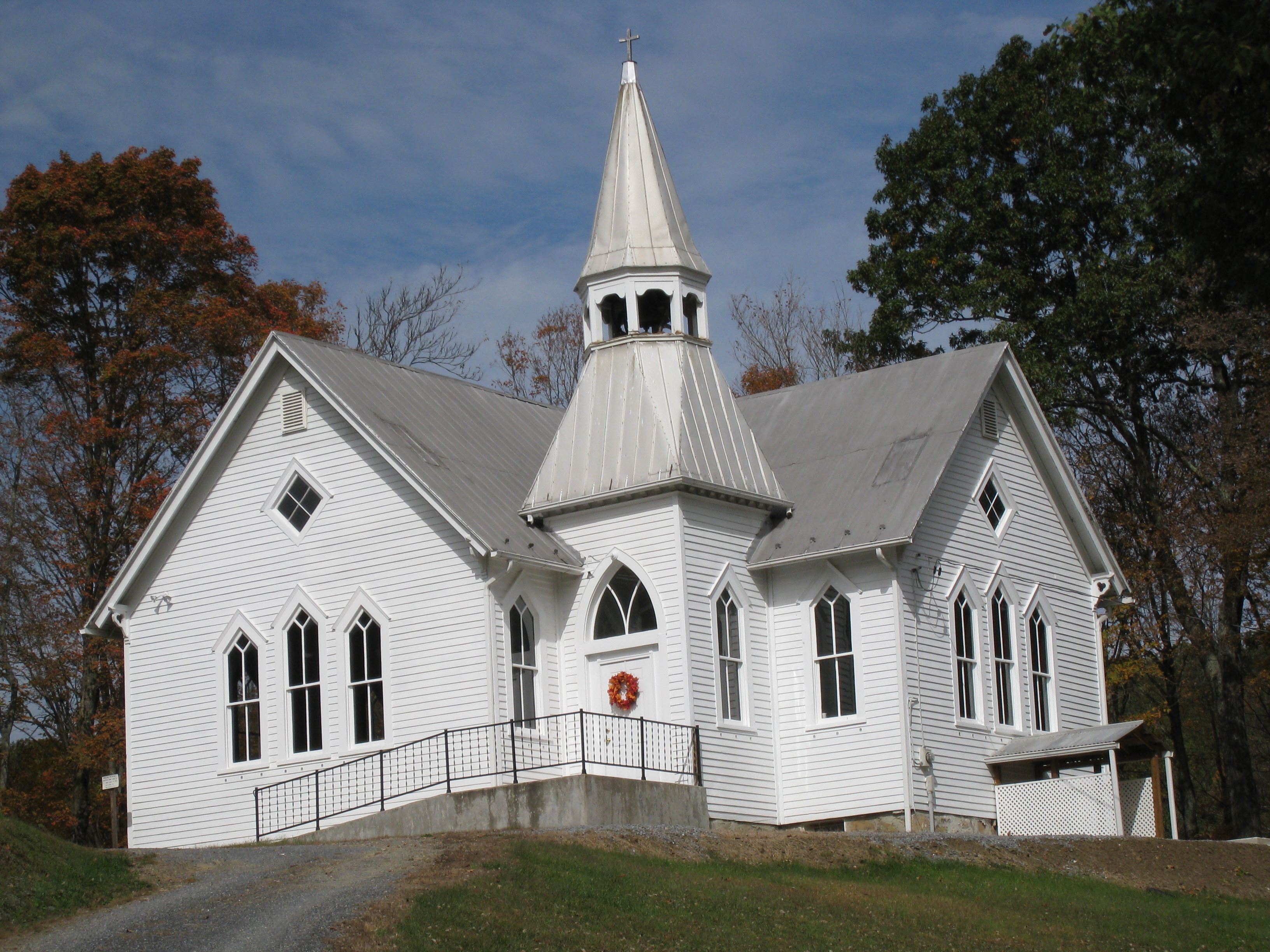
 Bethel United Methodist Church
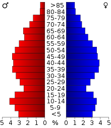 Alterspyramide für das Hampshire County
Nach der Volkszählung im Jahr 2000 lebten im Hampshire County 20.203 Menschen in 7.955 Haushalten und 5.640 Familien. Die Bevölkerungsdichte betrug 12 Einwohner pro Quadratkilometer. Ethnisch betrachtet setzte sich die Bevölkerung zusammen aus 98,04 Prozent Weißen, 0,83 Prozent Afroamerikanern, 0,24 Prozent amerikanischen Ureinwohnern, 0,16 Prozent Asiaten, 0,02 Prozent Bewohnern aus dem pazifischen Inselraum und 0,12 Prozent aus anderen ethnischen Gruppen; 0,59 Prozent stammten von zwei oder mehr Ethnien ab. 0,55 Prozent der Bevölkerung waren spanischer oder lateinamerikanischer Abstammung.
Von den 7.955 Haushalten hatten 31,3 Prozent Kinder und Jugendliche unter 18 Jahre, die bei ihnen lebten. 56,7 Prozent waren verheiratete, zusammenlebende Paare, 9,5 Prozent waren allein erziehende Mütter, 29,1 Prozent waren keine Familien, 24,6 Prozent waren Singlehaushalte und in 10,6 Prozent lebten Menschen im Alter von 65 Jahren oder darüber. Die Durchschnittshaushaltsgröße betrug 2,49 und die durchschnittliche Familiengröße lag bei 2,94 Personen.
Auf das gesamte County bezogen setzte sich die Bevölkerung zusammen aus 25,1 Prozent Einwohnern unter 18 Jahren, 7,1 Prozent zwischen 18 und 24 Jahren, 27,6 Prozent zwischen 25 und 44 Jahren, 25,6 Prozent zwischen 45 und 64 Jahren und 14,6 Prozent waren 65 Jahre alt oder darüber. Das Durchschnittsalter betrug 38 Jahre. Auf 100 weibliche Personen kamen 99,7 männliche Personen. Auf 100 Frauen im Alter von 18 Jahren oder darüber kamen statistisch 97,3 Männer.
Das jährliche Durchschnittseinkommen eines Haushalts betrug 31.666 USD, das Durchschnittseinkommen der Familien betrug 37.616 USD. Männer hatten ein Durchschnittseinkommen von 28.884 USD, Frauen 19.945 USD. Das Prokopfeinkommen betrug 14.851 USD. 12,9 Prozent der Familien und 16,3 Prozent der Bevölkerung lebten unterhalb der Armutsgrenze. Davon waren 22,7 Prozent Kinder oder Jugendliche unter 18 Jahre und 13,1 Prozent waren Menschen über 65 Jahre. [4]
Städte
Eingemeindete Ortschaften
- Capon Bridge
- Romney
Nicht eingemeindete Ortschaften
- Augusta
- Barnes Mill
- Bloomery
- Blues Beach
- Bubbling Spring
- Capon Lake
- Capon Springs
- Capon Springs Station
- Cold Stream
- Creekvale
- Davis Ford
- Delray
- Dillons Run
- Donaldson
- Forks of Cacapon
- Frenchburg
- Glebe
- Good
- Grace
- Green Spring
- Hainesville
- Hanging Rock
- Higginsville
- High View
- Hooks Mills
- Hoy
- Intermont
- Jericho
- Junction
- Kirby
- Largent
- Lehew
- Levels
- Little Cacapon
- Loom
- Mechanicsburg
- Millbrook
- Millen
- Millesons Mill
- Neals Run
- Nero
- North River Mills
- Okonoko
- Pancake
- Pin Oak
- Pleasant Dale
- Points
- Purgitsville
- Rada
- Raven Rocks
- Ridgedale
- Rio
- Ruckman
- Sector
- Sedan
- Shanks
- Shiloh
- Slanesville
- South Branch Depot
- Springfield
- Three Churches
- Vance
- Vanderlip
- Wappocomo
- Woodrow
- Yellow Spring
Siehe auch
Einzelnachweise
- ↑ Hampshire County im Geographic Names Information System des United States Geological Survey. Abgerufen am 22. Februar 2011
- ↑ U.S. Census Bureau _ Census of Population and Housing. Abgerufen am 28. Februar 2011
- ↑ Auszug aus Census.gov. Abgerufen am 28. Februar 2011
- ↑ Hampshire County, West Virginia, Datenblatt mit den Ergebnissen der Volkszählung im Jahre 2000 bei factfinder.census.gov.
Weblinks
- Official Hampshire County Website
- Hampshire County 250th Anniversary Homepage
- Hampshire Review Newspaper
- Hampshire County Arts Council
- Hampshire County Chamber of Commerce
- Hampshire County Convention & Visitors Bureau
- Hampshire County Schools & Board of Education
- Hampshire High School
- Hampshire County Office of Emergency Services
- Hampshire County Public Library
- Terry Gruber's Colonial Hampshire County Research Articles

Liste der Countys in West Virginia
Barbour | Berkeley | Boone | Braxton | Brooke | Cabell | Calhoun | Clay | Doddridge | Fayatte | Gilmer | Grant | Greenbrier | Hampshire | Hancock | Hardy | Harrison | Jackson | Jefferson | Kanawha | Lewis | Lincoln | Logan | Marion | Marshall | Mason | McDowell | Mercer | Mineral | Mingo | Monongalia | Monroe | Morgan | Nicholas | Ohio | Pendleton | Pleasants | Pocahontas | Preston | Putnam | Raleigh | Randolph | Ritchie | Roane | Summers | Taylor | Tucker | Tyler | Upshur | Wayne | Webster | Wetzel | Wirt | Wood | Wyoming
Wikimedia Foundation.
Schlagen Sie auch in anderen Wörterbüchern nach:
Hampshire County, West Virginia — Infobox U.S. County county = Hampshire County state = West Virginia founded year = 1753 founded date = seat wl = Romney largest city wl = Romney area total sq mi = 645 area total km2 = 1670 area land sq mi = 642 area land km2 = 1662 area water sq … Wikipedia
County Route 8 (Hampshire County, West Virginia) — Infobox road state=WV type=Secondary alternate name = South Branch River Road route=8 length mi= length round= length ref= established= direction a=North starting terminus= direction b=South ending terminus= counties=HampshireCounty Route 8 is a… … Wikipedia
National Register of Historic Places listings in Hampshire County, West Virginia — Location of Hampshire County in West Virginia This is a list of the National Register of Historic Places listings in Hampshire County, West Virginia. This is intended to be a complete list of the properties and districts on the National Register… … Wikipedia
List of county routes in Hampshire County, West Virginia — A State, Interstate and U.S. Route shield Highway names … Wikipedia
List of historic sites in Hampshire County, West Virginia — This is a complete list of historic sites in Hampshire County, West Virginia, United States. NRHP refers to whether the site is listed on the National Register of Historic Places.Hampshire County historic sitesee also*List of Registered Historic… … Wikipedia
Castle Mountain (Hampshire County, West Virginia) — Infobox Mountain Name = Castle Mountain Photo = Caption = Elevation = 1,260 feet (384 m) Location = West Virginia, USA Range = Ridge and Valley Appalachians Prominence = Coordinates = coord|39|23|37|N|78|25|07|W|type:mountain region:US… … Wikipedia
List of placenames in Hampshire County, West Virginia — This is a complete list of placenames in Hampshire County, West Virginia. Placename entries are compiled from the United States Geological Survey s Geographic Names Information System. Hampshire County placenames … Wikipedia
Hainesville, Hampshire County, West Virginia — Hainesville is an unincorporated community in Hampshire County, West Virginia, United States. Hainesville is located southwest of Slanesville at the crossroads of Old Martinsburg Road (County Route 45/9) and Kedron Road (County Route 45/11).… … Wikipedia
List of historical highway markers in Hampshire County, West Virginia — This is a list of Hampshire County Historical Highway Markers in Hampshire County, in the U.S. state of West Virginia. = Capon Springs = *Inscription: Capon Springs bears Indian name meaning the Medicine Waters. Discovered in 1765. Famous resort… … Wikipedia
Bloomery, Hampshire County, West Virginia — Bloomery is an unincorporated hamlet in Hampshire County in the U.S. state of West Virginia. Bloomery is located along the Bloomery Pike (West Virginia Route 127), northwest of Winchester, Virginia. According to the 2000 census, the Bloomery… … Wikipedia
Hampshire County (West Virginia)


18+
© Academic, 2000-2026
- Kontaktieren Sie uns: Unterstützung, Werbung
Wörterbücher Export, schritte mit PHP, Joomla, Drupal, WordPress, MODx.