- Allacapan
-
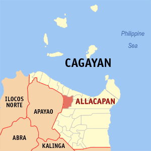
Municipality of Allacapan Lage von Allacapan in der Provinz Cagayan 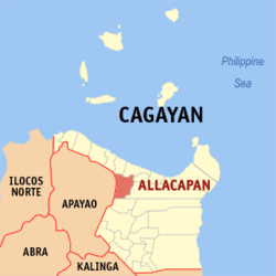
Basisdaten Bezirk: Cagayan Valley Provinz: Cagayan Barangays: 27 PSGC: 021503000 Einkommensklasse: 3. Einkommensklasse Haushalte: 5260 Zensus 1. Mai 2000Einwohnerzahl: 29.821 Zensus 1. August 2007Bevölkerungsdichte: 97,2 Einwohner je km² Fläche: 306,8 km² Koordinaten: 18° 13′ N, 121° 30′ O18.22153121.50467Koordinaten: 18° 13′ N, 121° 30′ O Postleitzahl: 3523 Geographische Lage auf den Philippinen 

Allacapan Allacapan ist eine Stadtgemeinde in der philippinischen Provinz Cagayan. Die Gemeinde grenzt im Westen an die Provinz Apayao. Die Einheimischen des Ortes gehören dem Volk Negrito an. Erst 1928 wurde Allacapan zur Stadtgemeinde ernannt.
Allacapan ist in die folgenden 27 Baranggays aufgeteilt:
- Bessang
- Binobongan
- Bulo
- Burot
- Capagaran
- Capalutan
- Capanickian Norte
- Capanickian Sur
- Cataratan
- Centro East
- Centro West
- Daan-Ili
- Dagupan
- Dalayap
- Gagaddangan
- Iringan
- Labben
- Maluyo
- Mapurao
- Matucay
- Nagattatan
- Pacac
- San Juan
- Silangan
- Tamboli
- Tubel
- Utan
Städte und Stadtgemeinden in der Provinz CagayanStädte: Tuguegarao City
Stadtgemeinden: Abulug | Alcala | Allacapan | Amulung | Aparri | Baggao | Ballesteros | Buguey | Calayan | Camalaniugan | Claveria | Enrile | Gattaran | Gonzaga | Iguig | Lal-Lo | Lasam | Pamplona | Peñablanca | Piat | Rizal | Sanchez-Mira | Santa Ana | Santa Praxedes | Santa Teresita | Santo Niño | Solana | Tuao
Wikimedia Foundation.
Schlagen Sie auch in anderen Wörterbüchern nach:
Allacapan — 18° 15′ 00″ N 121° 34′ 59″ E / 18.25, 121.583 … Wikipédia en Français
Allacapan — Original name in latin Allacapan Name in other language Allacapan State code PH Continent/City Asia/Manila longitude 18.22598 latitude 121.55615 altitude 8 Population 3645 Date 2011 07 31 … Cities with a population over 1000 database
Allacapan, Cagayan — Allacapan is a 4th class municipality in the province of Cagayan, Philippines. According to the 2000 census, it has a population of 26,960 people in 5,260 households.BarangaysAllacapan is politically subdivided into 27 barangays.External links*… … Wikipedia
List of Philippine National Railways stations — Philippine National Railways, operating two different rail lines, serves various parts of Luzon with its numerous stations. This list of stations lists all stations of both PNR Northrail and Southrail, as well as stations within Metro Manila,… … Wikipedia
Alcala (Philippinen) — Municipality of Alcala Lage von Alcala in der Provinz Cagayan Basisdaten Bezirk: Cagayan Valley … Deutsch Wikipedia
PH-CAG — Lage der Provinz Cagayan ist eine Provinz der Philippinen in der Region Cagayan Valley (auch Region II genannt), welche sich auf der Hauptinsel Luzón befindet. Die Hauptstadt der Provinz ist Tuguegarao, die auch das Zentrum der ganzen Region… … Deutsch Wikipedia
Tuguegarao — Lage der Stadt Taguegarao Tuguegarao ist eine Stadt auf den Philippinen in der Provinz Cagayan. Tuguegarao ist die Hauptstadt der Provinz und liegt am Fluss Cagayan an der südlichen Grenze von Cagayan. Im Jahre 2000 hatte die Stadt 120.645… … Deutsch Wikipedia
Claveria, Cagayan — Claveria Municipality Map of Cagayan showing the location of Claveria … Wikipedia
Lal-Lo, Cagayan — Lal Lo Municipality Map of Cagayan showing the location of Lal Lo … Wikipedia
List of cities and municipalities in the Philippines — This is a list of cities and municipalities in the Philippines arranged by province and in alphabetical order. As of 2006, there are 118 cities and 1509 municipalities.As of September 4, 2007, there are 136 cities, 1,495 municipalities, 81… … Wikipedia
Allacapan

18+
© Academic, 2000-2026
- Kontaktieren Sie uns: Unterstützung, Werbung
Wörterbücher Export, schritte mit PHP, Joomla, Drupal, WordPress, MODx.