- Hulterstad
-
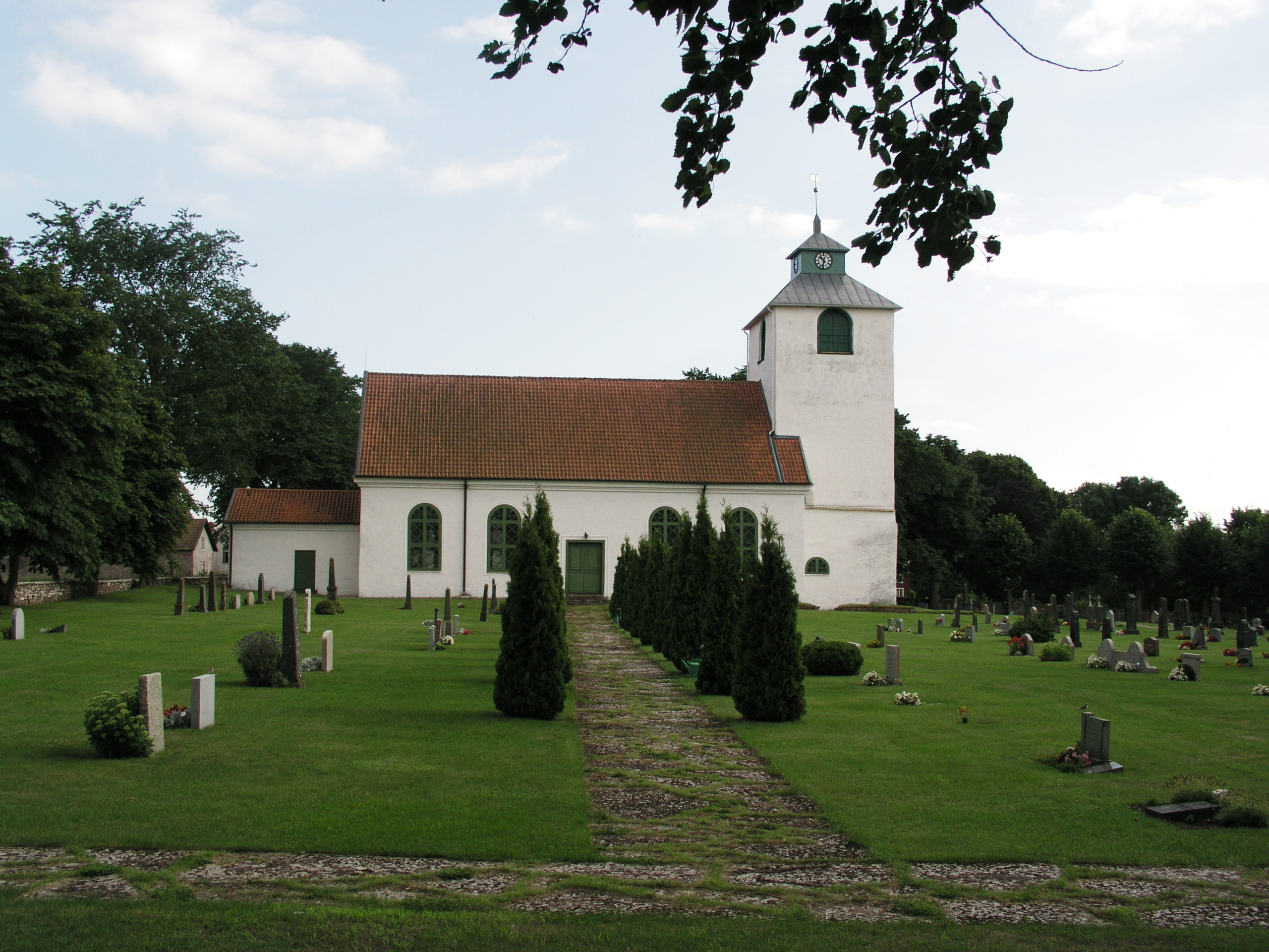
 Kirche von Hulterstad
Hulterstad 
Hilfe zu Wappen

Hulterstad Basisdaten Staat: Schweden Provinz (län): Kalmar län Historische Provinz (landskap): Öland Gemeinde (kommun): Mörbylånga Koordinaten: 56° 27′ N, 16° 34′ O56.44888888888916.566666666667Koordinaten: 56° 27′ N, 16° 34′ O Einwohner: 55 (31. Dezember 2005)[1] Fläche: 0,18 km² Bevölkerungsdichte: 306 Einwohner je km² Hulterstad ist eine zur Gemeinde Mörbylånga gehörende Ortschaft (småort) auf der schwedischen Ostseeinsel Öland.
Der Ort liegt im südöstlichen Teil der Insel und zieht sich als Reihendorf aus bäuerlichen Häusern an der östlichen Küstenstraße der Insel entlang. Nördlich liegt Triberga, südlich Skärlöv. Westlich von Hulterstad erstreckt sich die karge Landschaft des Stora Alvaret. Durch den Ort verläuft der Bach Penåsabäcken in Richtung Ostsee.
1283 wurde der Ort als Hulterstadhum erstmalig urkundlich erwähnt. Am 1. Juni 1676 sank das schwedische Kriegsschiff Kronan vor Hulterstad. Bis 1951 war Hulterstad eine eigenständige Gemeinde. Im Ort steht die Kirche von Hulterstad sowie eine der für Öland typischen Windmühlen. Südlich des Orts liegt ein aus der Eisenzeit stammendes Gräberfeld. In der Nähe befindet sich eine Schiffssetzung aus der Zeit der Wikinger.
Persönlichkeiten
1892 wurde der Photograph Carl E. Andersson in Hulterstad geboren.
Einzelnachweise
 Orte in der Gemeinde Mörbylånga
Tätorter: Algutsrum | Arontorp | Degerhamn | Färjestaden | Gårdby | Kastlösa | Mörbylånga | Skogsby | Vickleby
Småorter: Albrunna | Alby | Dörby | Glömminge | Grönhögen | Hagby-Bläsinge | Hult | Hulterstad | Karlevi | Norra Möckleby | Resmo och Gynge | Saxängen | Södra Kvinneby, Slagerstad och Stenås | Stora Frö | Strandskogen
Wikimedia Foundation.
Schlagen Sie auch in anderen Wörterbüchern nach:
Hulterstad — is a small coastal town on the southeastern part of the island of Öland, Sweden. Hulterstad is situated at the eastern fringe of the Stora Alvaret, a limestone pavement habitat which hosts a diversity of rare plants and has been designated a… … Wikipedia
Alby, Öland — Alby is a village on the Baltic Sea in the Hulterstad district at the western fringe of the Stora Alvaret. Archaeological evidence indicates this settlement to have been one of the oldest on the island of Öland, with excavations, dating to the… … Wikipedia
Viking — For other uses, see Viking (disambiguation). Danish seamen, painted mid twelfth century … Wikipedia
Öland — For the Finnish island, see Åland. For other uses, see Oland (disambiguation). Öland Map of Öland … Wikipedia
Mörbylanga — Gemeinde Mörbylånga Basisdaten … Deutsch Wikipedia
Öland — Isla de Öland Öland Vista de satélite (Nasa World Wind) Localización País … Wikipedia Español
Mörbylånga — Harbour of Mörbylånga … Wikipedia
Oseberg ship — The Oseberg ship (Viking Ship Museum, Norway) Detail from the Oseberg … Wikipedia
Stone circle (Iron Age) — The Stone Circles of the Iron Age (ca. 500 BC ca. 400 AD) were a characteristic burial custom of southern Scandinavia, especially on Gotland and in Götaland during the Pre Roman Iron Age and the Roman Iron Age. In Sweden, they are called… … Wikipedia
Stone ship — The Stone ship was a Germanic burial custom, typical of Scandinavia, built from tightly or loosely fit slabs or stones. Sometimes they are of monumental proportions. In Sweden, the size varies from 67 metres (Ale s Stones) to only a few metres.… … Wikipedia
Hulterstad


18+
© Academic, 2000-2026
- Kontaktieren Sie uns: Unterstützung, Werbung
Wörterbücher Export, schritte mit PHP, Joomla, Drupal, WordPress, MODx.