- Kanaga Island
-
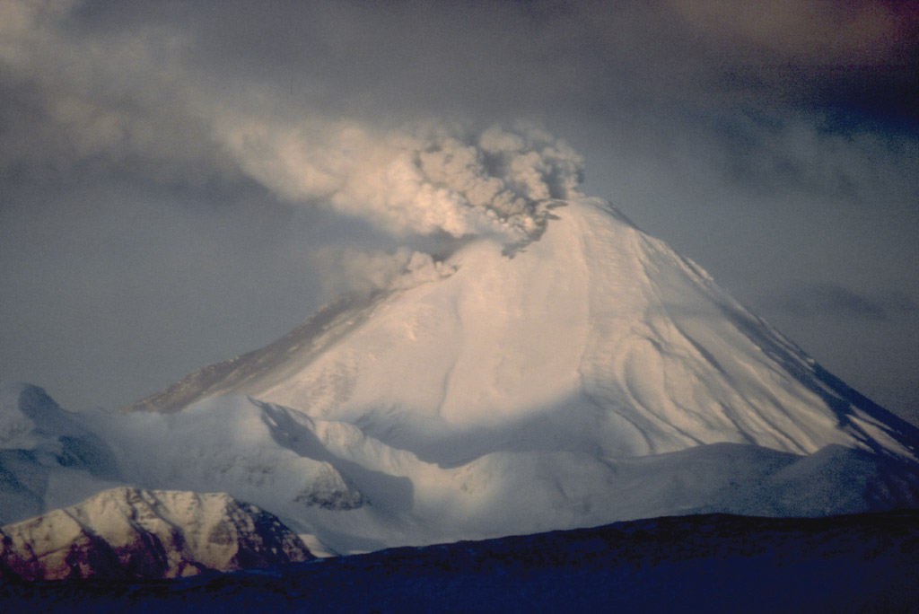
Kanaga Island Mount Kanaga
Gewässer Pazifischer Ozean Inselgruppe Aleuten Geographische Lage 51° 47′ N, 177° 15′ W51.783333-177.251307Koordinaten: 51° 47′ N, 177° 15′ W 

Länge 49 km Breite 9 km Fläche 480 km² Höchste Erhebung 1.307 m Einwohner (unbewohnt) Kanaga Island ist eine Insel der Andreanof Islands, einer Inselgruppe im Südwesten der Aleuten.
Die zum US-Bundesstaat Alaska zählende, unbewohnte Insel hat eine Landfläche von ungefähr 480 km², ist 49 km lang und im Schnitt knapp 9 km breit. Der Nordteil der Insel wird vom 1.307 m hohen aktiven Vulkan Mount Kanaga beherrscht, der zuletzt 1995 ausgebrochen ist.
Kanaga Island beherbergt unter anderem eine Brutkolonie an Bartalken, dem nach dem Zwergalk kleinsten Alkenvogel. Die Brutkolonie wurde erst 1994 entdeckt, als ein Forschungsschiff sich der Insel näherte um zwei Lavafelder näher zu untersuchen.[1]
Weblinks
- Information zum Vulkan Mount Kanaga (englisch)
- Kanaga im Global Volcanism Program der Smithsonian Institution (englisch)
Einzelbelege
- ↑ Anthony J. Gaston und Ian L. Jones: The Auks. Oxford University Press, Oxford 1998, ISBN 0-19-854032-9, S. 263 und S. 264
Inseln und Inselgruppen der Andreanof IslandsAdak | Agligadak | Amatigis Islands | Amlia | Anagaksik | Argonne | Asuksak | Atka | Aziak | Barbara | Black | Bobrof | Bolshoi Islands | Box | Castle | Chaika Rock | Channel | Chisak | Chugul | Cone | Cormorant | Crone | Delarof Islands | Dora | Eddy | Elf | Fenimore Rock | Gramp Rock | Great Sitkin | Green | Igitkin | Ikiginak | Ina | Kagalaska | Kanaga | Kanu | Kasatochi | Koniuji | Little Tanaga | North | Oglodak | Plum | Ringgold | Sadatanek | Sagchudak | Sagigik | Salt | Sea Parrot | Seguam | Silak | South | Staten | Tagadak | Tagalak | Tanaga | Tanaklek | The Signals | The Three Sisters | Tidgituk | Umak | Uyak | Whip
Wikimedia Foundation.
Schlagen Sie auch in anderen Wörterbüchern nach:
Kanaga Island — Location map Alaska label= lat=51.96648 long= 180.725952 position=right width=250 float=right caption=Location in AlaskaKanaga Island (Kanaga [Bergsland, K Aleut Dictionary Fairbanks: Alaska Native Language Center, 1994] in Aleut) is a part of… … Wikipedia
Kanaga Island — ▪ island, Alaska, United States one of the Andreanof Islands of the Aleutian Islands chain, southwestern Alaska, U.S. The uninhabited island measures 30 miles (50 km) long and 4 to 8 miles (6.5 to 13 km) wide; its northern tip is the site… … Universalium
Kanaga — may refer to: *Kanaga Island in the Andreanof Islands group of the Aleutian Islands in Alaska *Mount Kanaga, a volcano on Kanaga Island *the human effigy tribal figure, kanaga , that appeared on the original Malian independence flag adopted on… … Wikipedia
Mount Kanaga — Vorlage:Infobox Insel/Wartung/Bild fehlt Kanaga Island Gewässer Pazifischer Ozean Inselgruppe Aleuten Geographische Lage … Deutsch Wikipedia
Mount Kanaga — View, looking west to Kanaga Volcano in 1994 eruption. Elevation 4,288 ft (1,307 m) … Wikipedia
Isla Kanaga — … Wikipedia Español
Adak Island — Mount Adagdak Gewässer Pazifischer Ozean Inselgruppe … Deutsch Wikipedia
Bobrof Island — Vorlage:Infobox Insel/Wartung/Fläche fehlt Bobrof Island NASA Bild von Bobrof Island Gewässer … Deutsch Wikipedia
Castle Island (Aleuten) — Vorlage:Infobox Insel/Wartung/Bild fehltVorlage:Infobox Insel/Wartung/Fläche fehltVorlage:Infobox Insel/Wartung/Höhe fehlt Castle Island Gewässer Pazifischer Ozean Inselgruppe Aleuten … Deutsch Wikipedia
Bobrof Island — Location map Alaska label= lat=52.105964 long= 180.945335 position=right width=250 float=right caption=Location in AlaskaBobrof Island (Walĝa [Bergsland, K Aleut Dictionary Fairbanks: Alaska Native Language Center, 1994] in Aleut) is one of the… … Wikipedia
Kanaga Island

18+
© Academic, 2000-2026
- Kontaktieren Sie uns: Unterstützung, Werbung
Wörterbücher Export, schritte mit PHP, Joomla, Drupal, WordPress, MODx.