- Bobrof Island
-
Bobrof Island NASA-Bild von Bobrof Island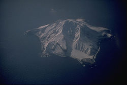
Gewässer Pazifischer Ozean Inselgruppe Aleuten Geographische Lage 51° 54′ 22″ N, 177° 26′ 47″ W51.9061111-177.4463889597Koordinaten: 51° 54′ 22″ N, 177° 26′ 47″ W 

Länge 4 km Höchste Erhebung 597 m Einwohner (unbewohnt) Karte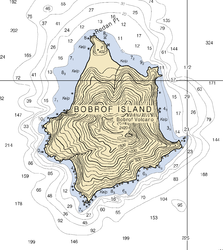
Bobrof Island ist eine kleine unbewohnte Vulkaninsel der Andreanof Islands, die zu den Aleuten gehört. Die etwa 4 km lange Insel liegt zwischen Kanaga Island und Tanaga Island.
Bobrof wurde 1852 von Mikhail Tebenkov als „Ostrov Bobrovoy Vilga“, zu deutsch Otter-Insel, erstmals in den Seekarten verzeichnet.
Weblinks
- Bobrof Island im Global Volcanism Program der Smithsonian Institution (englisch)
- Bobrof Island im Geographic Names Information System des United States Geological Survey
Inseln und Inselgruppen der Andreanof IslandsAdak | Agligadak | Amatigis Islands | Amlia | Anagaksik | Argonne | Asuksak | Atka | Aziak | Barbara | Black | Bobrof | Bolshoi Islands | Box | Castle | Chaika Rock | Channel | Chisak | Chugul | Cone | Cormorant | Crone | Delarof Islands | Dora | Eddy | Elf | Fenimore Rock | Gramp Rock | Great Sitkin | Green | Igitkin | Ikiginak | Ina | Kagalaska | Kanaga | Kanu | Kasatochi | Koniuji | Little Tanaga | North | Oglodak | Plum | Ringgold | Sadatanek | Sagchudak | Sagigik | Salt | Sea Parrot | Seguam | Silak | South | Staten | Tagadak | Tagalak | Tanaga | Tanaklek | The Signals | The Three Sisters | Tidgituk | Umak | Uyak | Whip
Wikimedia Foundation.
Schlagen Sie auch in anderen Wörterbüchern nach:
Bobrof Island — Location map Alaska label= lat=52.105964 long= 180.945335 position=right width=250 float=right caption=Location in AlaskaBobrof Island (Walĝa [Bergsland, K Aleut Dictionary Fairbanks: Alaska Native Language Center, 1994] in Aleut) is one of the… … Wikipedia
Bobrof — Vorlage:Infobox Insel/Wartung/Bild fehltVorlage:Infobox Insel/Wartung/Fläche fehlt Bobrof Island Gewässer Pazifischer Ozean Inselgruppe Aleuten Geographische Lage … Deutsch Wikipedia
Nunivak Island — Nunivak Maskette – Nunivak … Wikipedia
Medny Island — Map showing position of Commander Islands to the east of Kamchatka. The smaller island in the east is Medny and the larger island is Bering Island. Medny Island (also spelled Mednyy, Russian: остров Медный, sometimes called Copper Island in… … Wikipedia
Nelson Island (Alaska) — Nelson Native name: Qaluyaaq … Wikipedia
Unalaska Island — Unalaska Native name: Nawan Alaxsxa[1] Map of the island … Wikipedia
Adak Island — Mount Adagdak Gewässer Pazifischer Ozean Inselgruppe … Deutsch Wikipedia
Igitkin Island — Vorlage:Infobox Insel/Wartung/Fläche fehltVorlage:Infobox Insel/Wartung/Höhe fehlt Igitkin Island Igitkin Island, im Hintergrund Great … Deutsch Wikipedia
Chuginadak Island — Mount Cleveland erupts in 2006. Taken from the International Space Station Geography Location Aleutian Islands, Alaska, USA Coordinates … Wikipedia
Oglodak Island — Island … Wikipedia
Bobrof Island


18+
© Academic, 2000-2026
- Kontaktieren Sie uns: Unterstützung, Werbung
Wörterbücher Export, schritte mit PHP, Joomla, Drupal, WordPress, MODx.