- Kasatochi Island
-
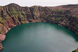
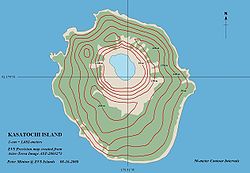
Kasatochi Island Der Kratersee auf Kasatochi Gewässer Pazifischer Ozean Inselgruppe Aleuten Geographische Lage 52° 10′ 17″ N, 175° 31′ 6″ W52.1713889-175.5183333314Koordinaten: 52° 10′ 17″ N, 175° 31′ 6″ W Länge 2,4 km Höchste Erhebung 314 m Einwohner (unbewohnt) Karte von Kasatochi Island Kasatochi Island ist eine unbewohnte Vulkaninsel der Andreanof Islands, die zu den Aleuten gehören. Das etwa 2,4 km lange Eiland liegt 15 km nordwestlich von Atka Island. Der die Insel beherrschende 288 m hohe Schichtvulkan besitzt einen 750 m weiten Gipfelkrater mit einem Kratersee und ist letztmalig 2008 ausgebrochen.
1802 wurde die Insel erstmals von Gawriil Andrejewitsch Sarytschew als Kosatochyey in einer Seekarte verzeichnet.
Ascheausbruch 2008
Ab dem 7. August 2008 erfolgte ein Ascheausbruch. Der Hauptteil der Wolke stieg in ca. 10.000 m und die Spitze bis auf ca. 15.000 m Höhe [1]. Anwesende Biologen mussten die Insel verlassen [2]. Der Ausbruch führte durch den Ascheeintrag in die Polaratmosphäre zu einem schneereichen Winter 2008/2009 [1]. Die letzte beobachtete Aktivität vor diesem Ausbruch war 1899.
Einzelnachweise
- ↑ a b http://www.fr-online.de/in_und_ausland/wissen_und_bildung/spezial_klimawandel/treibhauseffekt_und_ozonloch/?em_cnt=2152598&em_cnt_page=2
- ↑ Alaska Volcano Observatory website
Weblinks
- Kasatochi Island im Geographic Names Information System des United States Geological Survey
- Kasatochi Island im Global Volcanism Program der Smithsonian Institution (englisch)
- Informationen und Karten zum Vulkan Kasatochi (engl.)
Adak | Agligadak | Amatigis Islands | Amlia | Anagaksik | Argonne | Asuksak | Atka | Aziak | Barbara | Black | Bobrof | Bolshoi Islands | Box | Castle | Chaika Rock | Channel | Chisak | Chugul | Cone | Cormorant | Crone | Delarof Islands | Dora | Eddy | Elf | Fenimore Rock | Gramp Rock | Great Sitkin | Green | Igitkin | Ikiginak | Ina | Kagalaska | Kanaga | Kanu | Kasatochi | Koniuji | Little Tanaga | North | Oglodak | Plum | Ringgold | Sadatanek | Sagchudak | Sagigik | Salt | Sea Parrot | Seguam | Silak | South | Staten | Tagadak | Tagalak | Tanaga | Tanaklek | The Signals | The Three Sisters | Tidgituk | Umak | Uyak | Whip
Wikimedia Foundation.


