- Seguam Island
-
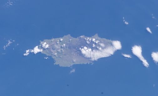
Seguam Island NASA-Bild von Seguam Island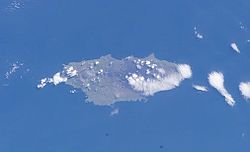
Gewässer Pazifischer Ozean Inselgruppe Aleuten Geographische Lage 52° 20′ N, 172° 25′ W52.333333-172.416667Koordinaten: 52° 20′ N, 172° 25′ W 

Länge 21 km Breite 13 km Fläche 207,3 km² Einwohner (unbewohnt) Seguam Island ist die östlichste Insel der Andreanof Islands, einer Inselgruppe im Südwesten der Aleuten.
Die zum US-Bundesstaat Alaska zählende, unbewohnte Insel hat eine Landfläche von 207,3 km², ist 21 km lang und etwa 13 km breit. Im Westen befindet sich mit dem Vulkan Pyre Peak (auch Seguam-Vulkan genannt) (1.054 m) der höchste Punkt der Insel. Im Osten der Insel liegen noch zwei kleinere Vulkankegel.
Weblinks
 Commons: Seguam Island – Sammlung von Bildern, Videos und AudiodateienInseln und Inselgruppen der Andreanof Islands
Adak | Agligadak | Amatigis Islands | Amlia | Anagaksik | Argonne | Asuksak | Atka | Aziak | Barbara | Black | Bobrof | Bolshoi Islands | Box | Castle | Chaika Rock | Channel | Chisak | Chugul | Cone | Cormorant | Crone | Delarof Islands | Dora | Eddy | Elf | Fenimore Rock | Gramp Rock | Great Sitkin | Green | Igitkin | Ikiginak | Ina | Kagalaska | Kanaga | Kanu | Kasatochi | Koniuji | Little Tanaga | North | Oglodak | Plum | Ringgold | Sadatanek | Sagchudak | Sagigik | Salt | Sea Parrot | Seguam | Silak | South | Staten | Tagadak | Tagalak | Tanaga | Tanaklek | The Signals | The Three Sisters | Tidgituk | Umak | Uyak | Whip
Wikimedia Foundation.
Schlagen Sie auch in anderen Wörterbüchern nach:
Seguam Island — Infobox Mountain Name= Seguam Island Photo= Caption= Elevation= Convert|3458|ft|m|0|abbr=on location=Aleutian Islands, Alaska, USA Range = Prominence = Coordinates = coord|52|19|22.2|N|172|28|37.6|W|type:mountain region:US|display=inline,title… … Wikipedia
Seguam Island — Sp Seigvãmo salà Ap Seguam Island L Andrejanovo ss. (Aleutai), JAV (Aliaska) … Pasaulio vietovardžiai. Internetinė duomenų bazė
Seguam — may refer to:*Seguam Island, an island in the Andreanof Islands in the Aleutian Islands in Alaska. *Seguam Pass, a strait between Amlia Island and Seguam Island in the Aleutian Islands in Alaska … Wikipedia
Seguam Pass — is a strait between the Bering Sea and the North Pacific Ocean in the Aleutian Islands in Alaska. It lies between Seguam Island to the east and Amlia Island to the west. [ Rand McNally New Universal World Atlas , p. 109] NotesReferences* Rand… … Wikipedia
Seguam — L île Seguam (Seguam Island en anglais, Saĝuugamax en aléoute) est une petite île de l archipel Andreanof dans l ouest de l arc des îles Aléoutiennes en Alaska (États Unis). L île est montagneuse et de forme ovale avec une superficie de 207 km².… … Wikipédia en Français
Mount Seguam — Incandescent lava fountaining from a fissure eruption near Pyre Peak on Seguam Island. Elevation 3,45 … Wikipedia
Amlia Island — Vorlage:Infobox Insel/Wartung/Bild fehlt Amlia Island Gewässer Pazifischer Ozean Inselgruppe Aleuten Geographische Lage … Deutsch Wikipedia
Nunivak Island — Nunivak Maskette – Nunivak … Wikipedia
Medny Island — Map showing position of Commander Islands to the east of Kamchatka. The smaller island in the east is Medny and the larger island is Bering Island. Medny Island (also spelled Mednyy, Russian: остров Медный, sometimes called Copper Island in… … Wikipedia
Unalaska Island — Unalaska Native name: Nawan Alaxsxa[1] Map of the island … Wikipedia
Seguam Island

18+
© Academic, 2000-2026
- Kontaktieren Sie uns: Unterstützung, Werbung
Wörterbücher Export, schritte mit PHP, Joomla, Drupal, WordPress, MODx.