- Little Tanaga Island
-
Little Tanaga Island NASA-Bild von Little Tanaga Island 
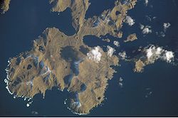
Gewässer Pazifischer Ozean Inselgruppe Aleuten Geographische Lage 51° 51′ N, 176° 10′ W51.8436111-176.1641667121Koordinaten: 51° 51′ N, 176° 10′ W Länge 16 km Höchste Erhebung 121 m Einwohner (unbewohnt) Little Tanaga Island ist eine kleine unbewohnte Insel der Andreanof Islands, die zu den Aleuten gehören. Die etwa 16 km lange und 121 m hohe Insel ist die kleine Nachbarinsel von Tanaga Island.
Weblinks
Inseln und Inselgruppen der Andreanof IslandsAdak | Agligadak | Amatigis Islands | Amlia | Anagaksik | Argonne | Asuksak | Atka | Aziak | Barbara | Black | Bobrof | Bolshoi Islands | Box | Castle | Chaika Rock | Channel | Chisak | Chugul | Cone | Cormorant | Crone | Delarof Islands | Dora | Eddy | Elf | Fenimore Rock | Gramp Rock | Great Sitkin | Green | Igitkin | Ikiginak | Ina | Kagalaska | Kanaga | Kanu | Kasatochi | Koniuji | Little Tanaga | North | Oglodak | Plum | Ringgold | Sadatanek | Sagchudak | Sagigik | Salt | Sea Parrot | Seguam | Silak | South | Staten | Tagadak | Tagalak | Tanaga | Tanaklek | The Signals | The Three Sisters | Tidgituk | Umak | Uyak | Whip
Wikimedia Foundation.
Schlagen Sie auch in anderen Wörterbüchern nach:
Little Tanaga Island — Location map Alaska label= lat=51.94361 long= 179.60417 position=right width=250 float=right caption=Location in AlaskaLittle Tanaga Island (Tanagax̂ [Bergsland, K Aleut Dictionary Fairbanks: Alaska Native Language Center, 1994] in Aleut) is an… … Wikipedia
Tanaga Island — Mount Tanaga auf Tanaga Island Gewässer Pazifischer Ozean Inselgruppe … Deutsch Wikipedia
Mount Tanaga — Vorlage:Infobox Insel/Wartung/Bild fehltVorlage:Infobox Insel/Wartung/Fläche fehlt Tanaga Island Gewässer Pazifischer Ozean Inselgruppe Aleuten Geographische Lage … Deutsch Wikipedia
Chisak Island — Vorlage:Infobox Insel/Wartung/Bild fehltVorlage:Infobox Insel/Wartung/Fläche fehlt Chisak Island Gewässer Pazifischer Ozean Inselgruppe Aleuten Geographische Lage … Deutsch Wikipedia
Silak Island — Vorlage:Infobox Insel/Wartung/Bild fehltVorlage:Infobox Insel/Wartung/Fläche fehltVorlage:Infobox Insel/Wartung/Höhe fehlt Silak Island Gewässer Pazifischer Ozean Inselgruppe Aleuten … Deutsch Wikipedia
Île Petite Tanaga — Vue aérienne de l île Géographie Pays … Wikipédia en Français
Umak Island — Vorlage:Infobox Insel/Wartung/Bild fehltVorlage:Infobox Insel/Wartung/Fläche fehltVorlage:Infobox Insel/Wartung/Höhe fehlt Umak Island Gewässer Pazifischer Ozean Inselgruppe Aleuten … Deutsch Wikipedia
Chagulak Island — Location in Alaska … Wikipedia
Nunivak Island — Nunivak Maskette – Nunivak … Wikipedia
Medny Island — Map showing position of Commander Islands to the east of Kamchatka. The smaller island in the east is Medny and the larger island is Bering Island. Medny Island (also spelled Mednyy, Russian: остров Медный, sometimes called Copper Island in… … Wikipedia